
Scientia Silvae Sinicae ›› 2024, Vol. 60 ›› Issue (4): 31-39.doi: 10.11707/j.1001-7488.LYKX20220586
Previous Articles Next Articles
Yusup Asadilla1,2( ),Halik Ümüt1,*,Dilixiati Babierjiang3,Cheng Lei3,Jianxin Wei3,Abliz Abdulla4,Jianluo Cui1,Xixiang He1
Received:2022-08-21
Online:2024-04-25
Published:2024-05-23
Contact:
Halik ümüt
E-mail:asadilla@xju.edu.cn
CLC Number:
Yusup Asadilla,Halik Ümüt,Dilixiati Babierjiang,Cheng Lei,Jianxin Wei,Abliz Abdulla,Jianluo Cui,Xixiang He. Spatial Distribution Pattern and Intraspecific Competition of Populus euphratica Population in the Lower Reaches of the Tarim River Based on LiDAR Data[J]. Scientia Silvae Sinicae, 2024, 60(4): 31-39.
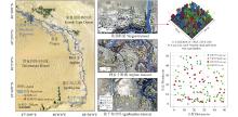
Fig.1
Study area and terrestrial laser scanning measuring plots distribution"


Fig.2
Variation of groundwater depth with distance from the river channel"
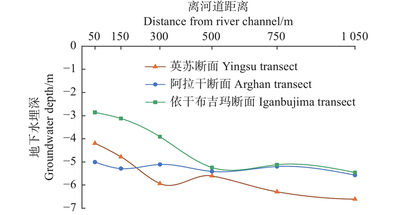
Table 1
Stand aggregation index and cluster index of P. euphratica"
| 河段 River section | 样地 Plot | 株数 Trees | 聚集指数 Aggregation index | z值 z-value | 格局类型 Distribution pattern | 丛生指数 Cluster index | t值 t-value | 格局类型 Distribution pattern |
| 英苏 Yingsu | A1 | 83 | 1.23 | 4.09** | U | 1.80 | 1.65 | A |
| A2 | 54 | 0.98 | ?0.27 | R | 2.20 | 2.24* | A | |
| A3 | 78 | 0.89 | ?1.72 | A | 1.70 | 1.52 | A | |
| A4 | 46 | 1.03 | 0.46 | R | 1.40 | 0.69 | A | |
| A5 | 22 | 1.19 | 1.78 | R | 1.40 | 0.59 | A | |
| 阿拉干 Arghan | B1 | 100 | 1.00 | 0.04 | R | 3.14 | 4.77** | A |
| B2 | 73 | 0.56 | ?7.03** | A | 2.27 | 2.62* | A | |
| B3 | 76 | 0.94 | ?0.89 | R | 1.09 | 0.19 | R | |
| B4 | 66 | 0.94 | 0.84 | R | 1.75 | 1.51 | A | |
| B5 | 44 | 0.87 | ?1.64 | R | 2.01 | 1.83* | A | |
| 依干布吉玛 Iganbujima | C1 | 110 | 0.93 | ?1.27 | R | 3.00 | 3.45** | A |
| C2 | 48 | 0.51 | ?6.30** | A | 4.00 | 4.93** | A | |
| C3 | 33 | 0.88 | ?1.25 | R | 1.00 | 0.43 | R | |
| C4 | 31 | 0.60 | ?4.19** | A | 3.00 | 2.86** | A | |
| C5 | 18 | 0.55 | ?4.62** | A | 1.20 | 2.45* | A |

Fig.3
Point pattern g(r) function values in plots The black thick line is the g(r) function values, the two gray lines are the upper and lower confidence interval bounds, and the red dashed line is the function expected value under the null model."

Table 2
Spatial distribution pattern of P. euphratica in different age classes"
| 样地 Plots | 幼龄树 Young trees | 中龄树 Middle age trees | 成熟龄树 Mature trees | 老龄树 Old trees | |||||||||||
| 比例 Ratio (%) | g(r) | 格局 Pattern | 比例 Ratio (%) | g(r) | 格局 Pattern | 比例 Ratio (%) | g(r) | 格局 Pattern | 比例 Ratio (%) | g(r) | 格局 Pattern | ||||
| A1 | 11 | 8.5 | A | 30 | 2.2 | R | 38 | 2.1 | R | 21 | 3.3 | R | |||
| A2 | 20 | 6.3 | R | 26 | 3.1 | R | 13 | 3.4 | R | 12 | 5.4 | R | |||
| A3 | 23 | 2.5 | R | 63 | 4.8 | A | 11 | 4.6 | R | 3 | — | — | |||
| A4 | 24 | 4.8 | R | 41 | 4.9 | R | 26 | 2.5 | R | 9 | 0.4 | R | |||
| A5 | 14 | 17.4 | R | 23 | 16.7 | R | 32 | 7.8 | R | 32 | 2.7 | R | |||
| B1 | 26 | 2.8 | R | 58 | 3.5 | A | 14 | 2.4 | R | 2 | 10.6 | R | |||
| B2 | 5 | 27.9 | R | 70 | 10.1 | A | 19 | 8.4 | R | 5 | 14.1 | R | |||
| B3 | 16 | 4.8 | R | 55 | 3.8 | A | 22 | 3.6 | R | 7 | 8.2 | R | |||
| B4 | 13 | 3.7 | R | 68 | 3.2 | R | 18 | 4.8 | R | 1 | — | — | |||
| B5 | 32 | 3.8 | R | 18 | 26.3 | R | 23 | 2.6 | R | 27 | 4.8 | R | |||
| C1 | 43 | 2.1 | R | 45 | 2.6 | A | 5 | 4.9 | R | 6 | 8 | R | |||
| C2 | 9 | 54.2 | A | 34 | 9.2 | A | 55 | 9.5 | A | 2 | — | — | |||
| C3 | 9 | 11.1 | R | 45 | 3.4 | R | 18 | 3.7 | R | 27 | 1.6 | R | |||
| C4 | 10 | 22.3 | R | 35 | 7.8 | R | 23 | 16.1 | R | 32 | 8.6 | A | |||
| C5 | 6 | 18.2 | R | 42 | 4.5 | A | 26 | 11.7 | R | 26 | 1.7 | R | |||
Table 3
Spatial association of P. euphratica in different age groups"
| 样地 Plots | 幼龄-中龄 Young-Middle | 幼龄-成熟龄 Young-Mature | 幼龄-老龄 Young-Old | 中龄-成熟龄 Middle-Matures | 中龄-老龄 Middle-Old | 成熟龄-老龄 Mature- Old | |||||||||||
| g12(r) | 关联性 Association | g12(r) | 关联性 Association | g12(r) | 关联性 Association | g12(r) | 关联性 Association | g12(r) | 关联性 Association | g12(r) | 关联性 Association | ||||||
| A1 | 3.9 | + | 1.5 | ? | 3.4 | ? | 1.8 | ? | 1.5 | ? | 1.8 | ? | |||||
| A2 | 3.5 | ? | 5.6 | ? | 2.7 | ? | 9.5 | + | 2.9 | ? | 1.9 | ? | |||||
| A3 | 2.7 | ? | 2.1 | ? | ? | ? | 2.2 | ? | ? | ? | ? | ? | |||||
| A4 | 1.9 | ? | 2.3 | ? | 0.2 | ? | 4.1 | + | 4.2 | ? | 3.2 | ? | |||||
| A5 | 3.2 | ? | 6.5 | + | 3.6 | ? | 8.1 | + | 4.1 | ? | 5.6 | ? | |||||
| B1 | 3.1 | + | 1.7 | ? | 2.5 | ? | 1.8 | ? | 2.8 | ? | 3.5 | ? | |||||
| B2 | 9.2 | + | 11.6 | + | 0.1 | ? | 2.5 | ? | 7.8 | ? | 2.4 | ? | |||||
| B3 | 1.4 | ? | 3.2 | ? | 2.8 | ? | 2.1 | ? | 1.6 | ? | 1.9 | ? | |||||
| B4 | 3.5 | ? | 5.8 | ? | ? | ? | 3.6 | + | ? | ? | ? | ? | |||||
| B5 | 3.1 | ? | 5.5 | ? | 3.4 | ? | 3.8 | ? | 7.5 | ? | 4.6 | ? | |||||
| C1 | 1.6 | ? | 1.1 | ? | 0.9 | ? | 2.5 | ? | 1.9 | ? | ? | ? | |||||
| C2 | 6.3 | + | 2.6 | ? | ? | ? | 6.8 | + | ? | ? | ? | ? | |||||
| C3 | 2.8 | ? | 2.6 | ? | 4.4 | ? | 3.2 | ? | 1.2 | ? | 2.7 | ? | |||||
| C4 | 5.8 | ? | 5.9 | ? | 1.1 | ? | 3.9 | + | 2.8 | ? | 4.2 | ? | |||||
| C5 | 4.2 | ? | 3.5 | ? | 2.6 | ? | 3.4 | ? | 6.5 | ? | 3.4 | ? | |||||
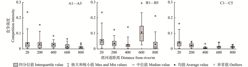
Table 4
Competition intensity index of plots"
| 样地 Plots | A1 | A2 | A3 | A4 | A5 |
| CI | 0.034 | 0.031 | 0.028 | 0.016 | 0.010 |
| 样地 Plots | B1 | B2 | B3 | B4 | B5 |
| CI | 0.053 | 0.036 | 0.026 | 0.1081 | 0.030 |
| 样地 Plots | C1 | C2 | C3 | C4 | C5 |
| CI | 0.042 | 0.023 | 0.006 | 0.014 | 0.008 |

Fig.4
The change trend of competition intensity with DBH"
| 阿德·阿布拉. 塔里木河下游生态输水对地下水补给量影响的研究. 中国水能及电气化, 2021, 200 (11): 27- 31,13. | |
| Abula A. Study on the impact to the groundwater recharge by ecological water conveyance in lower reaches of Tarim River. China Water Power and Electrification, 2021, 200 (11): 27- 31,13. | |
| 艾里西尔·库尔班, 徐海良, 玉米提·哈力克, 等. 2019. 塔里木河下游生态保护与实践. 乌鲁木齐: 新疆科学技术出版社. | |
| Kurban A, Xu H L, Halik Ü, et al. 2019. Theory and practice of ecosystem restoration in the lower Tarim River. Urumqi: Xinjiang Science and Technology Press. [in Chinese] | |
| 白 元, 徐海量, 涂文霞, 等. 塔里木河干流胡杨种群结构与分布格局研究. 西北植物学报, 2013, 33 (6): 1216- 1223. | |
| Bai Y, Xu H L, Tu W X, et al. Population structure and spatial distribution of the Populus euphratica in the mainstream of the Tarim River. Acta Botanica Boreall-Occidentalla Sinica, 2013, 33 (6): 1216- 1223. | |
| 陈亚宁, 吾买尔江·吾布力, 艾克热木·阿布拉, 等. 2021. 塔里木河下游近20 a输水的生态效益监测分析. 干旱区地理, 44(3), 605−611. | |
| Chen Y N, Wubuli W, Abula A, et al. 2013. Monitoring and analysis of ecological benefits of water conveyance in the lower reaches of Tarim River in recent 20 years. Arid Land Geography, 44(3): 605−611. [in Chinese]) | |
| 仇建习, 汤孟平, 沈利芬, 等. 天目山近自然毛竹林空间结构与胸径的关系. 生态学报, 2015, 35 (12): 4081- 4088. | |
| Qiu J X, Tang M P, Shen L P, et al. The relationship between spatial structure and DBH of close-to-nature Phyllostachys edulis stands in Tianmu Mountain. Acta Ecologica Sinica, 2015, 35 (12): 4081- 4088. | |
| 郭飞龙, 徐刚标, 卢孟柱, 等. 基于MaxEnt模型分析胡杨潜在适宜分布区. 林业科学, 2020, 56 (5): 184- 192. | |
| Guo F L, Xu G B, Lu M Z, et al. Prediction of potential suitable distribution areas for Populus euphratica using the MaxEnt model. Scientia Silvae Sinicae, 2020, 56 (5): 184- 192. | |
| 郭庆华, 苏艳军, 胡天宇, 等. 2018. 激光雷达森林生态应用—理论、方法及实例. 北京: 高等教育出版社. | |
| Guo Q H, Su Y J, Hu T Y, et al. 2018. LiDAR principles, processing and applications in forest ecology. Beijing: Higher Educated Press. [in Chinese] | |
| 韩 路, 王海珍, 彭 杰, 等. 2010. 不同生境胡杨种群径级结构与格局动态研究. 北京林业大学学报, 32(1): 7−12. | |
| Han L, Wang H Z, Peng J, et al. 2010. Size-class structure and distribution pattern of Populus euphratica Oliv. in different habitats. Journal of Beijing Forestry University, 32(1): 7−12. [in Chinese] | |
| 韩 路, 王海珍, 王家强, 等. 塔里木荒漠绿洲过渡带植物种间关联性分析. 生态环境学报, 2015, 24 (6): 932- 937. | |
| Han L, Wang H Z, Wang J Q, et al. Interspecific associations of plants in desert-oasis ecotone in Tarim Basin. Ecology and Environmental Sciences, 2015, 24 (6): 932- 937. | |
| 韩 路, 王家强, 王海珍, 等. 塔里木荒漠绿洲过渡带主要种群生态位与空间格局分析. 植物科学学报, 2016, 34 (3): 352- 360. | |
| Han L, Wang J Q, Wang H Z, et al. Niche and spatial distribution pattern analysis of the main populations of the Tarim desert-oasis ecotone. Plant Sciences Journal, 2016, 34 (3): 352- 360. | |
|
韩 路, 席琳乔, 王家强, 等. 塔里木河上游灰胡杨种群生活史特征与空间分布格局. 生态学报, 2013, 33 (19): 6181- 6190.
doi: 10.5846/stxb201305211136 |
|
|
Han L, Xi L Q, Wang J Q, et al. Life history characteristics and spatial distribution of Populus pruinosa population at the upper reaches of Tarim River. Acta Ecologica Sinica, 2013, 33 (19): 6181- 6190.
doi: 10.5846/stxb201305211136 |
|
| 姜 鹏, 孟京辉, 陆元昌, 等. 马尾松近自然改造初期的混交度与分布格局. 西北林学院学报, 2014, 29 (5): 147- 150,155. | |
| Jiang P, Meng J H, Lu Y C, et al. Minglings and spatial distribution of Pinus massoniana plantation in the initial stage of near-nature transformation. Journal of Northwest Forestry University, 2014, 29 (5): 147- 150,155. | |
| 兰国玉, 雷瑞德. 2003. 植物种群空间分布格局研究方法概述. 西北林学院学报, 18(2): 17−21. | |
| Lan G W, Lei R D. 2003. Brief introduction of spatial methods to distribution patterns of population. Journal of Northwest Forestry University, 18(2): 17−21. [in Chinese] | |
| 刘 帅, 李建军, 李 丹, 等. 林木空间分布格局分析方法比较及其适应性. 林业科学, 2019, 55 (11): 73- 84. | |
| Liu S, Li J J, Li D, et al. Comparison and adaptability of analytical methods for spatial distribution patterns in forest. Scientia Silvae Sinicae, 2019, 55 (11): 73- 84. | |
| 马 季, 高婷婷, 王 寅, 等. 额济纳胡杨空间分布格局及其与微生境异质性的关系研究. 林业调查规划, 2020, 2020,45 (3): 107- 112. | |
| Ma J, Gao T T, Wang Y, et al. Relationships between microhabitat heterogeneity and spatial distribution pattern of Populus euphratica in Ejina of Inner Mongolia. Forest Inventory and Planning, 2020, 2020,45 (3): 107- 112. | |
| 买尔当·克依木, 玉米提·哈力克, 塔依尔江·艾山, 等. 人工输水影响下塔里木河下游阿拉干断面幼龄胡杨胸径变化. 东北林业大学学报, 2014, 42 (9): 15- 18,32. | |
| Keyimu M, Halik Ü, Aishan T, et al. DBH change of juvenile Populus euphratica in the lower reaches of Tarim River under water conveyances. Journal of Northeast Foresrty University, 2014, 42 (9): 15- 18,32. | |
| 孟宪宇. 2006. 测树学. 北京: 中国林业出版社. | |
| Meng X Y. 2006. Forest measurement. Beijing: China Forestry Publishing House. [in Chinese] | |
| 宁 默, 李 娜, 师庆东, 等. 基于Ripley’s K的沙漠腹地达理雅博依绿洲胡杨种群空间格局研究. 西南大学学报(自然科学版), 2020, 42 (12): 73- 82. | |
| Ning M, Li N, Shi Q D, et al. A Ripley's K function-based study of the spatial pattern of Populus euphratica population in Daliyaboyi Oasis in desert hinterland. Journal of Southwest University (Natural Science Edition), 2020, 42 (12): 73- 82. | |
| 史浩伯, 孙桂丽, 陈亚宁, 等. 基于生态位分化的塔里木河下游植物种群分布格局与共存机制. 西部林业科学, 2019, 48 (6): 120- 126. | |
| Shi H B, Sun G L, Chen Y N, et al. Plant populations in the lower reaches of the Tarim River based on niche differentiated distribution pattern and coexistence mechanism. Journal of West China Forestry Science, 2019, 48 (6): 120- 126. | |
| 史月冬, 郑 宏, 叶代全, 等. 杉木生长性状的空间与竞争效应及其对遗传参数估计的影响. 林业科学, 2022, 58 (5): 75- 84. | |
| Shi Y D, Zheng H, Ye D Q, et al. Spatial and competition effects for growth traits of Chinese fir and their impacts on estimations of genetic parameters. Scientia Silvae Sinicae, 2022, 58 (5): 75- 84. | |
| 王世绩, 陈炳浩, 李护群. 胡杨林. 1995. 北京: 中国环境科学出版社. | |
| Wang S, Chen B, Li H. 1995. Euphrates Poplar Forest. China Environmental Science Press. [in Chinese] | |
| 邢海涛, 陆元昌, 刘宪钊, 等. 基于近自然改造的马尾松林分竞争强度研究. 北京林业大学学报, 2016, 38 (9): 42- 54. | |
| Xing H T, Lu Y C, Liu X Z, et al. Competition intensity of Pinus massoniana stand based on close-to-nature management. Journal of Beijing Forestry University, 2016, 38 (9): 42- 54. | |
| 徐梦辰, 陈永金, 刘加珍, 等. 塔里木河中游水文影响下的胡杨种群格局动态. 生态学报, 2016, 36 (9): 2646- 2655. | |
| Xu M C, Chen Y J, Liu J Z, et al. The distribution pattern dynamics of Populus euphratica influenced by hydrology in the middle reaches of the Tarim River. Acta Ecologica Sinica, 2016, 36 (9): 2646- 2655. | |
| 于 军, 王海珍, 陈加利, 等. 塔里木河流域荒漠河岸林胡杨群落的空间格局研究. 中国沙漠, 2011, 31 (4): 913- 918. | |
| Yu J, Wang H Z, Chen J L, et al. Spatial pattern of Populus euphratica community of desert riparian forest in Tarim River Basin. Journal of Desert Research, 2011, 31 (4): 913- 918. | |
| 张 兰, 张 华, 赵传燕, 2014. 黑河下游胡杨种群的点格局分析. 应用生态学报, 25(12): 3407−3412. | |
| Zhang L, Zhang H, Zhao C Y, et al. 2014. Point pattern analysis of Populus euphratica population in the lower reaches of Heihe River. Chinese Journal of Applied Ecology, 25(12): 3407−3412. [in Chinese] | |
| 张 静, 雍 会. 2018. 干旱区塔里木河流域地下水生态调节与监测预警研究. 中国农业资源与区划, 39(5): 77−83. | |
| Zhang J, Yong H. 2018. Ecological regulation and monitoring warning of groundwater in the arid area Tarim River basin, Chinese Journal of Agricultural Resources and Regional Planning, 39(5): 77−83. [in Chinese] | |
| 赵正帅, 郑亚琼, 梁继业, 等. 塔里木河流域胡杨和灰叶胡杨克隆分株空间分布格局. 应用生态学报, 2016, 27 (2): 403- 411. | |
| Zhao Z S, Zheng Y Q, Liang J Y, et al. Spatial distribution pattern of Populus euphratica and P. pruinosa clonal ramets in Tarim River Basin, China. Chinese Journal of Applied Ecology, 2016, 27 (2): 403- 411. | |
|
周禧琳, 吕瑞恒, 韩 路, 等. 和田河不同生境灰胡杨种群结构特征及竞争关系分析. 西北林学院学报, 2018, 33 (1): 43- 48.
doi: 10.3969/j.issn.1001-7461.2018.01.07 |
|
|
Zhou X L, Lu R H, Han L, et al. Population structure and intraspecific competition of Populus pruinosa in different habits along the up reaches of Hotan River. Journal of Northwest Forestry University, 2018, 33 (1): 43- 48.
doi: 10.3969/j.issn.1001-7461.2018.01.07 |
|
| 周莹莹, 陈亚宁, 朱成刚, 等. 塔里木河下游胡杨(Populus euphratica)种群结构. 中国沙漠, 2018, 38 (2): 315- 323. | |
| Zhou Y Y, Chen Y N, Zhu C G, et al. Population structure characteristics of Population euphratica in the lower reaches of Tarim River. Journal of Desert Research, 2018, 38 (2): 315- 323. | |
| Aishan T, Betz F, Halik Ü, et al. 2018. Biomass carbon sequestration potential by riparian forest in the Tarim River watershed, northwest China: implication for the mitigation of climate change impact. Forests, (9) 4: 196. | |
|
Béland M, Lussier J M, Bergeron Y, et al. Structure, spatial distribution, and competition in mixed jack pine (Pinus banksiana) stands on clay soils of eastern Canada. Annals of Forest Science, 2003, 60, 609- 617.
doi: 10.1051/forest:2003053 |
|
|
David F, Moore P. Notes on contagious distributions in plant populations. Annals of Botany, 1954, 18, 47- 53.
doi: 10.1093/oxfordjournals.aob.a083381 |
|
| Halik Ü, Aishan T, Betz F, et al. 2019. Effectiveness and challenges of ecological engineering for desert riparian forest restoration along China’s largest inland river. Ecological Engineering, 127: 11−22. | |
| Kint V. (2005). Structural development in ageing temperate Scots pine stands. Forest Ecology and Management, 214: 237–250. | |
|
Miao N, Jiao P P, Tao W J, et al. Structural dynamics of Populus euphratica forests in different stages in the upper reaches of the Tarim River in China. Scientific Report, 2020, 10, 3196.
doi: 10.1038/s41598-020-60139-7 |
|
|
Song J, Betz F, Aishan T, et al. Impact of water supply on the restoration of the severely damaged riparian plants along the Tarim River in Xinjiang, Northwest China. Ecological Indicators, 2024, 158, 111570.
doi: 10.1016/j.ecolind.2024.111570 |
|
| Thomas F M, Lang P. Growth and water relations of riparian poplar forests under pressure in Central Asia's Tarim River Basin. River Research and Applications, 2020, 37 (4): 1- 8. | |
| Vandekerkhove K, Vanhellemont M, Vrška T, et al. 2018. Very large trees in a lowland old-growth beech (Fagus sylvatica L.) forest: density, size, growth and spatial patterns in comparison to reference sites in Europe. Forest Ecology and Management, 417: 1–17. | |
|
Wei Z, Halik Ü, Aishan T, et al. Spatial distribution patterns of trunk internal decay of euphrates poplar riparian forest along the Tarim River, Northwest China. Forest Ecology and Management, 2022, 522, 120434.
doi: 10.1016/j.foreco.2022.120434 |
|
|
Yang J D, Zhang Z M, Dawazhaxi, et al. Spatial distribution patterns and intra-specific competition of pine (Pinus yunnanensis) in abandoned farmland under the sloping land conservation program. Ecological Engineering, 2019, 135, 17- 27.
doi: 10.1016/j.ecoleng.2019.04.026 |
|
|
Yusup A, Halik Ü, Abliz A, et al. Population structure and spatial distribution pattern of Populus euphratica riparian forest under environmental heterogeneity along the Tarim River, Northwest China. Frontiers in Plant Science, 2022, 13, 844819.
doi: 10.3389/fpls.2022.844819 |
| Viewed | ||||||
|
Full text |
|
|||||
|
Abstract |
|
|||||