
Scientia Silvae Sinicae ›› 2022, Vol. 58 ›› Issue (10): 24-34.doi: 10.11707/j.1001-7488.20221003
• Special Issue: Forest Fire Prevention Relevant Resource Monitoring, Analysis and Management Techniques in Zhangjiakou Competition Area of the Beijing Olympic Winter Games • Previous Articles Next Articles
Dongbo Xie1,2,3,Yakai Lei3,Yuchao Zhang4,Qingwang Liu1,5,Liyong Fu1,2,*,Qiao Chen1,2
Received:2021-12-22
Online:2022-10-25
Published:2023-04-23
Contact:
Liyong Fu
CLC Number:
Dongbo Xie,Yakai Lei,Yuchao Zhang,Qingwang Liu,Liyong Fu,Qiao Chen. Estimation of Canopy Cover in the Core Area of Winter Olympic Games Based on Airborne LiDAR Data[J]. Scientia Silvae Sinicae, 2022, 58(10): 24-34.
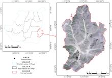
Fig.1
Location of sample sites in the study area"


Fig.2
Laser LiDAR point cloud pretreatment process"
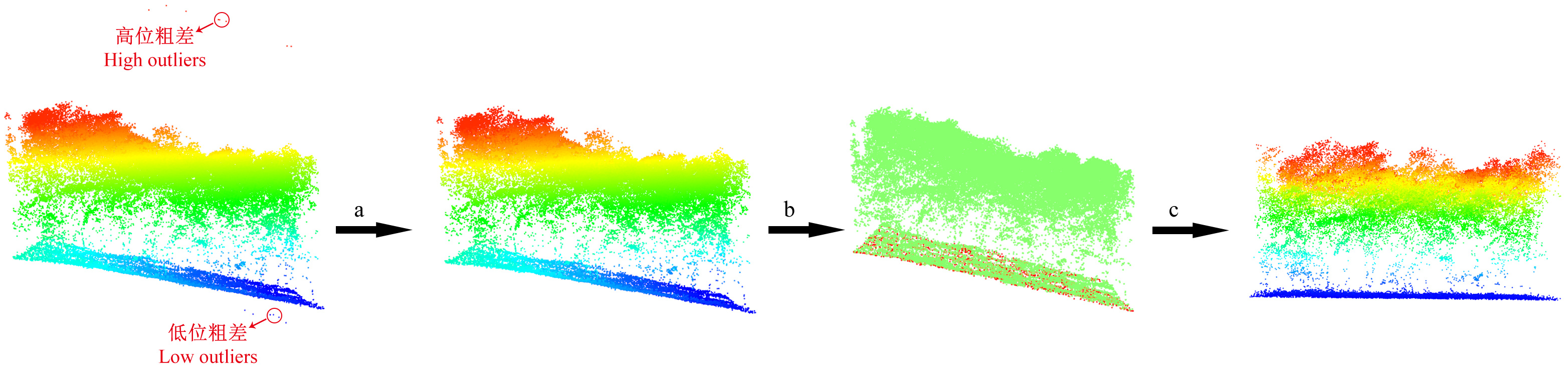
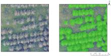
Fig.3
Estimation of canopy cover by visual interpretation"

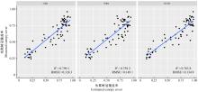
Fig.4
Fitting map of measured canopy cover and estimated canopy cover"
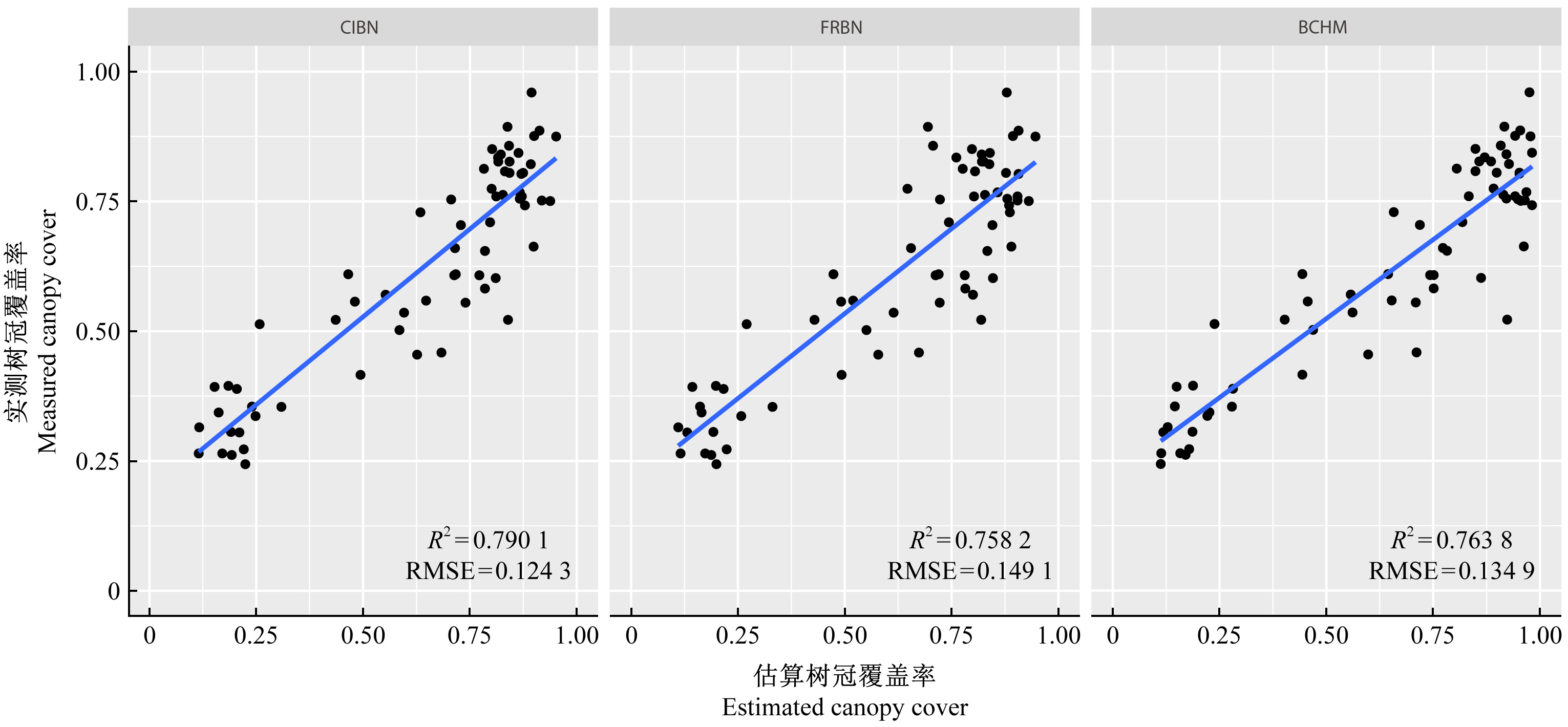
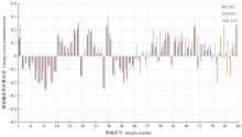
Fig.5
Histogram of estimation error of canopy cover"
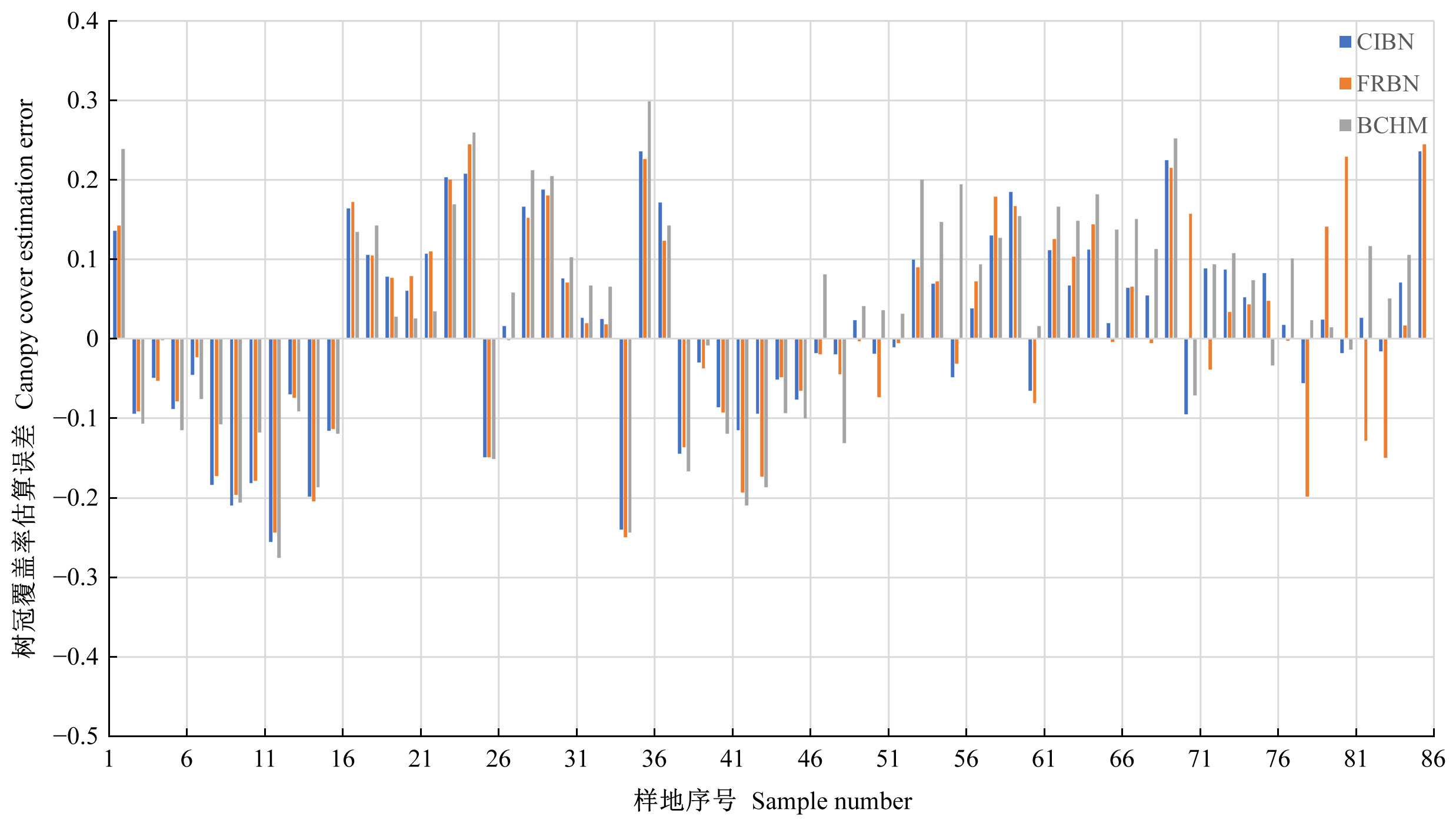
Table 1
Basic statistic of canopy cover estimation error"
| 估算方法 Estimation method | 样地数量 Number of sample | 最小值 Min.(%) | 最大值 Max.(%) | 平均值 Mean(%) | 标准差 Standard deviation |
| CIBN | 67 | -25.55 | 23.63 | 1.17 | 0.116 6 |
| FRBN | 67 | -24.96 | 24.47 | 1.34 | 0.128 7 |
| BCHM | 67 | -27.53 | 29.91 | 3.31 | 0.136 1 |
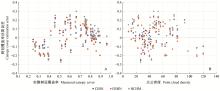
Fig.6
Scatter plot of canopy cover estimation error"
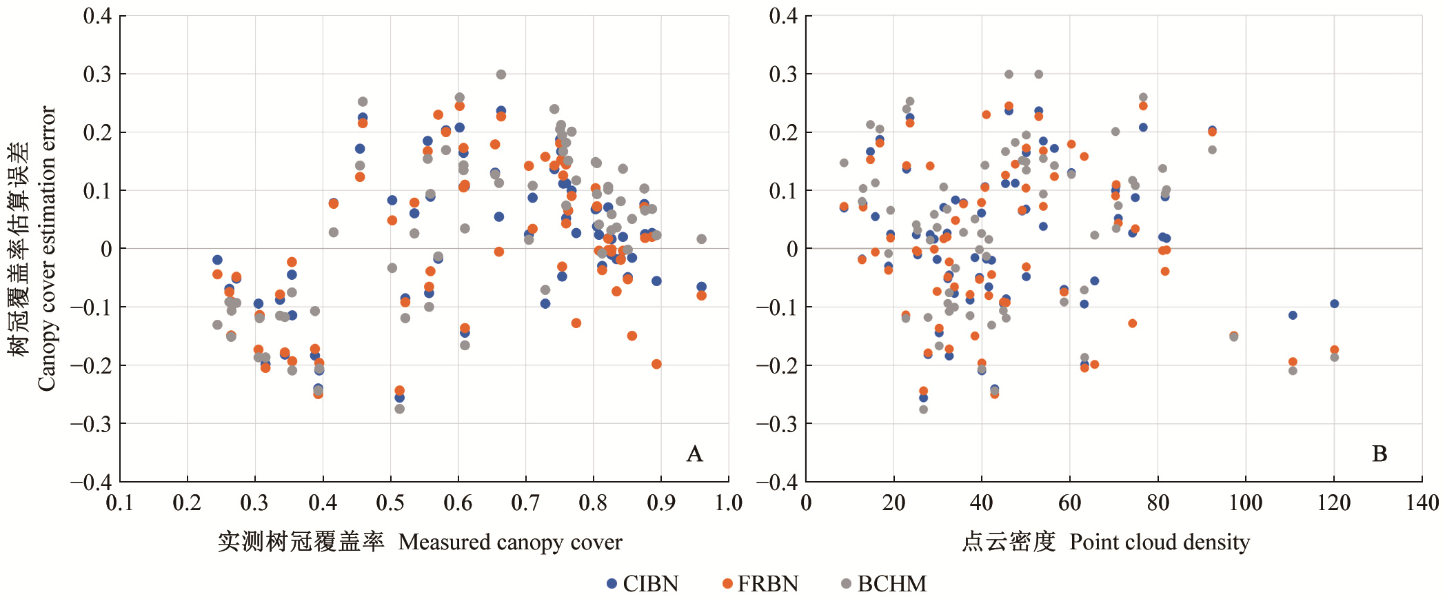
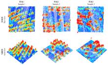
Fig.7
LiDAR point cloud for low estimation sample sites"
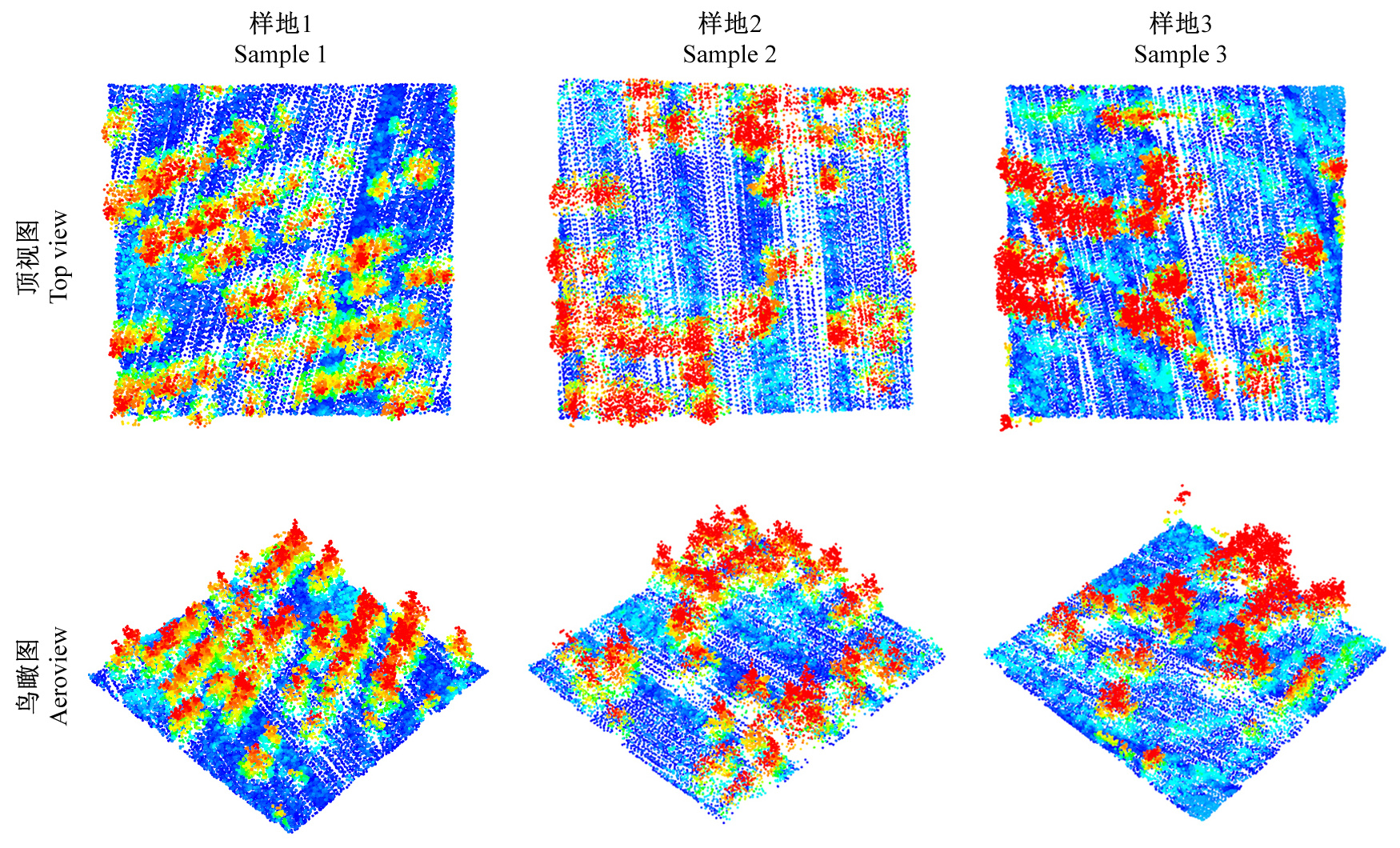
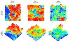
Fig.8
LiDAR point cloud for high estimation sample sites"


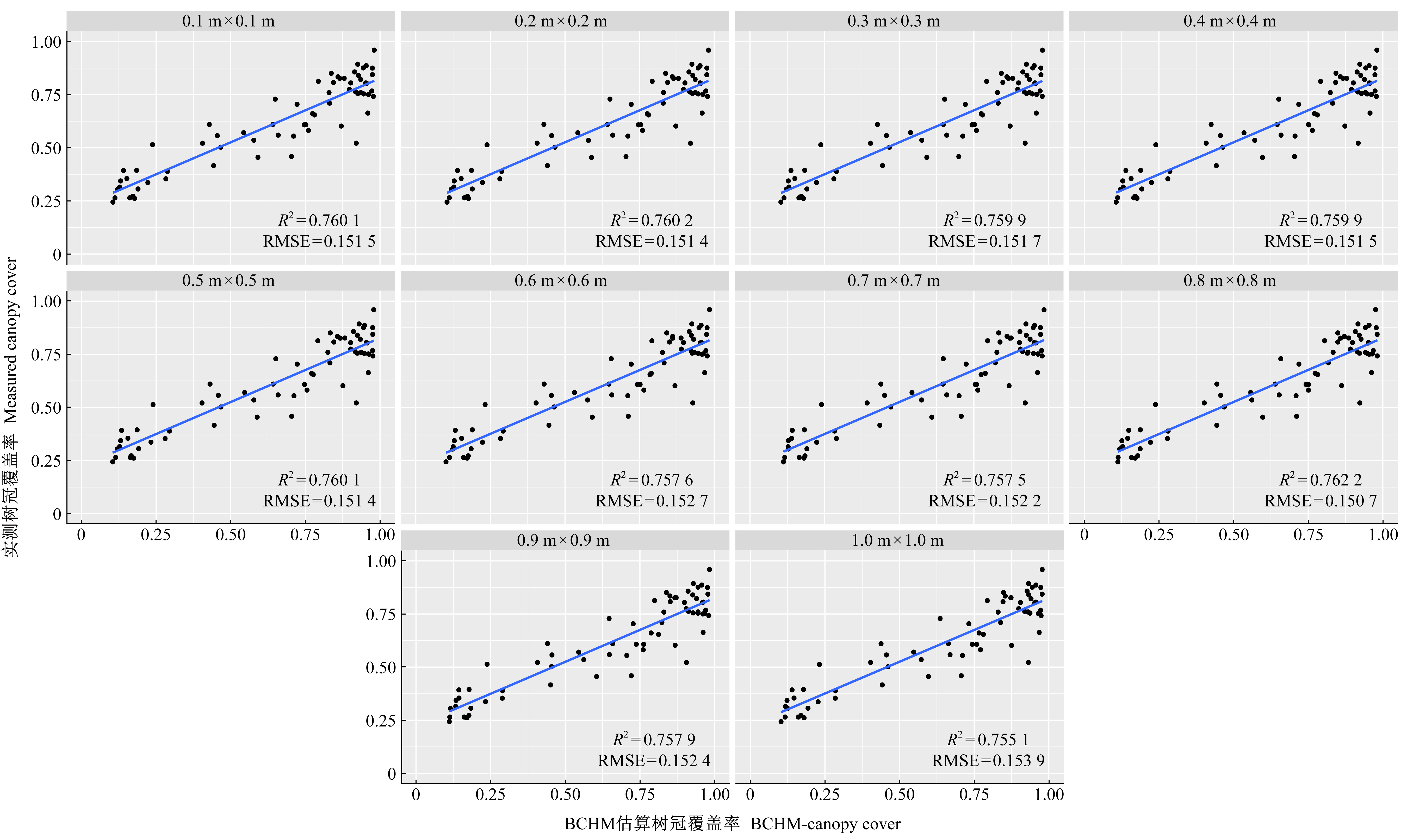
Fig.9
Estimation of ten kinds of grid resolution"
| 高云飞, 李智广, 杨胜天, 等. 基于SPOT5影像的郁闭度反演方法. 水土保持研究, 2012, 19 (2): 267- 270. | |
| Gao Y F , Zhi-Guang L I , Yang S T , et al. Study on canopy density retrieval method from SPOT5. Research of Soil and Water Conservation, 2012, 19 (2): 267- 270. | |
| 李丹, 张俊杰, 赵梦溪. 基于FCM和分水岭算法的无人机影像中林分因子提取. 林业科学, 2019, 55 (5): 180- 187. | |
| Li D , Zhang J J , Zhao M X . Extraction of stand factors in UAV image based on FCM and watershed algorithm. Scientia Silvae Sinicae, 2019, 55 (5): 180- 187. | |
|
李永宁, 张宾兰, 秦淑英, 等. 郁闭度及其测定方法研究与应用. 世界林业研究, 2008, 21 (1): 40- 46.
doi: 10.13348/j.cnki.sjlyyj.2008.01.006 |
|
|
Li Y N , Zhang B L , Qin S Y . Review of research and application of forest canopy closure and its measuring methods. World Forestry Research, 2008, 21 (1): 40- 46.
doi: 10.13348/j.cnki.sjlyyj.2008.01.006 |
|
|
谭炳香, 李增元, 陈尔学, 等. Hyperion高光谱数据森林郁闭度定量估测研究. 北京林业大学学报, 2006, 28 (3): 95- 101.
doi: 10.3321/j.issn:1000-1522.2006.03.017 |
|
|
Tan B X , Li Z Y , Chen E X , et al. Estimating forest crown closure using Hyperion hyperspectral data. Journal of Beijing Forestry University, 2006, 28 (3): 95- 101.
doi: 10.3321/j.issn:1000-1522.2006.03.017 |
|
|
吴飏, 张登荣, 张汉奎, 等. 结合图像纹理特征的森林郁闭度遥感估测. 林业科学, 2012, 48 (2): 48- 53.
doi: 10.3969/j.issn.1006-2505.2012.02.016 |
|
|
Wu Y , Zhang D R , Zhang H K , et al. Remote sensing estimation of forest canopy density combined with texture features. Scientia Silvae Sinicae, 2012, 48 (2): 48- 53.
doi: 10.3969/j.issn.1006-2505.2012.02.016 |
|
| 王蕊, 邢艳秋, 王立海, 等. 联合星载ICESat-GLAS波形与多光谱Landsat-TM影像的森林郁闭度估测. 应用生态学报, 2015, 26 (6): 1657- 1664. | |
| Wang R , Xing Y Q , Wang L H , et al. Estimating forest canopy cover by combining spaceborne ICESat-GLAS waveforms and multispectral Landsat-TM images. Chinese Journal of Applied Ecology, 2015, 26 (6): 1657- 1664. | |
| 张瑞英, 庞勇, 李增元, 等. 结合机载LiDAR和LANDSAT ETM+数据的温带森林郁闭度估测. 植物生态学报, 2016, 40 (2): 102- 115. | |
| Zhang R Y , Pang Y , Li Z Y , et al. Canopy closure estimation in a temperate forest using airborne LiDAR and LANDSAT ETM+ data. Chinese Journal of Plant Ecology, 2016, 40 (2): 102- 115. | |
| 赵峰, 庞勇, 李增元, 等. 机载激光雷达和航空数码影像单木树高提取. 林业科学, 2009, 45 (10): 81- 87. | |
| Zhao F , Pang Y , Li Z Y , et al. Extraction of individual tree height using a combination of aerial digital camera imagery and LiDAR. Scientia Silvae Sinicae, 2009, 45 (10): 81- 87. | |
| 赵勋, 岳彩荣, 李春干, 等. 基于机载LiDAR点云数据森林郁闭度估测. 遥感技术与应用, 2020, 35 (5): 1136- 1145. | |
| Zhao X , Yue C R , Li C G , et al. Estimation of forest canopy density based on airborne LiDAR point cloud data. Remote Sensing Technology and Application, 2020, 35 (5): 1136- 1145. | |
| Avery T E, Burkhart H E. 2015. Forest measurements. Waveland Press, pp. 160-162. | |
|
Blackard J A , Finco M V , Helmer E H , et al. Mapping US forest biomass using nationwide forest inventory data and moderate resolution information. Remote Sensing of Environment, 2008, 112 (4): 1658- 1677.
doi: 10.1016/j.rse.2007.08.021 |
|
|
Bunnell F L , Vales D J . Comparison of methods for estimating forest overstory cover: differences among techniques. Canadian Journal of Forest Research, 1990, 20 (1): 101- 107.
doi: 10.1139/x90-014 |
|
|
Coops N C , Hilker T , Wulder M A , et al. Estimating canopy structure of douglas-fir forest stands from discrete-return LiDAR. Trees, 2007, 21 (3): 295- 310.
doi: 10.1007/s00468-006-0119-6 |
|
| Donnelly D M, Johnson R R. 1997. Westside cascades variant of the forest vegetation simulator. WO-Forest Management Services Center. USDA Forest Service. Fort Collins, CO. | |
|
Frazer G W , Magnussen S , Wulder M A , et al. Simulated impact of sample plot size and co-registration error on the accuracy and uncertainty of LiDAR-derived estimates of forest stand biomass. Remote Sensing of Environment, 2011, 115 (2): 636- 649.
doi: 10.1016/j.rse.2010.10.008 |
|
| Garman S L , Cissel J H , Mayo J H , et al. Accelerating development of late-successional conditions in young managed douglas-fir stands: a simulation study. USDA Forest Service - General Technical Report PNW, 2003, 557 (557): 1- 57. | |
| Gill S J , Biging G S , Murphy E C . Modeling conifer tree crown radius and estimating canopy cover. Forest Ecology and Management, 2000, 126 (3): 405- 416. | |
| Gschwantner T , Schadauer K , Vidal C , et al. Common tree definitions for national forest inventories in Europe. Tanpakushitsu Kakusan Koso Protein Nucleic Acid Enzyme, 2015, 43 (2): 2073- 2079. | |
| Guo Q , Zhao X , Su Y , et al. Improved progressive TIN densification filtering algorithm for airborne LiDAR data in forested areas. ISPRS Journal of Photogrammetry and Remote Sensing, 2016, 117, 79- 91. | |
| He Q S , Li N . Estimation of individual tree parameters using small-footprint LiDAR with different density in a coniferous forest//Advanced Materials Research. Trans Tech Publications Ltd, 2012, 518, 5320- 5323. | |
| Hershey J L , McDill M E , Miller D A , et al. A Voxel-based individual tree stem detection method using airborne LiDAR in mature northeastern US forests. Remote Sensing, 2022, 14 (3): 806. | |
| Hopkinson C , Chasmer L . Testing LiDAR models of fractional cover across multiple forest ecozones. Remote Sensing of Environment, 2009, 113 (1): 275- 288. | |
| Jakubowski M K , Guo Q , Kelly M . Tradeoffs between LiDAR pulse density and forest measurement accuracy. Remote Sensing of Environment, 2013, 130, 245- 253. | |
| Jennings S , Brown N , Sheil D . Assessing forest canopies and understorey illumination: canopy closure, canopy cover and other measures. Forestry: an International Journal of Forest Research, 1999, 72 (1): 59- 74. | |
| Kato A , Moskal L M , Schiess P , et al. Capturing tree crown formation through implicit surface reconstruction using airborne LiDAR data. Remote Sensing of Environment, 2016, 113 (6): 1148- 1162. | |
| Khosravipour A , Skidmore A K , Isenburg M . Generating spike-free digital surface models using LiDAR raw point clouds: a new approach for forestry applications. International Journal of Applied Earth Observation & Geoinformation, 2016, 52, 104- 114. | |
| Korhonen L , Korhonen K T , Rautiainen M , et al. Estimation of forest canopy cover: a comparison of field measurement techniques. Silva Fennica, 2006, 40 (4): 577- 588. | |
| Korhonen L , Korpela I , Heiskanen J , et al. Airborne discrete-return LiDAR data in the estimation of vertical canopy cover, angular canopy closure and leaf area index. Remote Sensing of Environment, 2011, 115 (4): 1065- 1080. | |
| Lee A C , Lucas R M . A LiDAR-derived canopy density model for tree stem and crown mapping in Australian forests. Remote Sensing of Environment, 2007, 111 (4): 493- 518. | |
| Li S , Dai L , Wang H , et al. Estimating leaf area density of individual trees using the point cloud segmentation of terrestrial LiDAR data and a voxel-based model. Remote Sensing, 2017, 9 (11): 1202. | |
| Liu Q , Fu L , Wang G , et al. Improving estimation of forest canopy cover by introducing loss ratio of laser pulses using airborne LiDAR. IEEE Transactions on Geoscience and Remote Sensing, 2019, 58 (1): 567- 585. | |
| Ma Q , Su Y , Guo Q . Comparison of canopy cover estimations from airborne LiDAR, aerial imagery, and satellite imagery. IEEE Journal of Selected Topics in Applied Earth Observations and Remote Sensing, 2017, 10 (9): 4225- 4236. | |
| Medhurst J L , Beadle C L . Crown structure and leaf area index development in thinned and unthinned Eucalyptus nitens plantations. Tree Physiology, 2001, 21 (12/13): 989- 999. | |
| Paletto A , Tosi V . Forest canopy cover and canopy closure: comparison of assessment techniques. European Journal of Forest Research, 2009, 128 (3): 265- 272. | |
| Parent J R , Volin J C . Assessing the potential for leaf-off LiDAR data to model canopy closure in temperate deciduous forests. ISPRS Journal of Photogrammetry and Remote Sensing, 2014, 95, 134- 145. | |
| Popescu S C , Zhao K . A voxel-based LiDAR method for estimating crown base height for deciduous and pine trees. Remote Sensing of Environment, 2008, 112 (3): 767- 781. | |
| Rautiainen M , Stenberg P , Nilson T . Estimating canopy cover in Scots pine stands. Silva Fennica, 2005, 39 (1): 137- 142. | |
| Riano D , Meier E , Allgöwer B , et al. Modeling airborne laser scanning data for the spatial generation of critical forest parameters in fire behavior modeling. Remote Sensing of Environment, 2003, 86 (2): 177- 186. | |
| Pitknen J . Individual tree detection in digital aerial images by combining locally adaptive binarization and local maxima methods. Revue Canadienne De Recherche Forestière, 2001, 31 (31): 832- 844. | |
| Smart L S , Swenson J J , Christensen N L , et al. Three-dimensional characterization of pine forest type and red-cockaded woodpecker habitat by small-footprint, discrete-return LiDAR. Forest Ecology and Management, 2012, 281, 100- 110. | |
| Treitz P , Lim K , Woods M , et al. LiDAR sampling density for forest resource inventories in Ontario, Canada. Remote Sensing, 2012, 4 (4): 830- 848. | |
| Vauhkonen J , Tokola T , Maltamo M , et al. Effects of pulse density on predicting characteristics of individual trees of Scandinavian commercial species using alpha shape metrics based on airborne laser scanning data. Canadian Journal of Remote Sensing, 2008, 34 (sup2): S441- S459. |
| [1] | Yonglei Shi,Zhihui Wang,Shiming Li,Chunyi Li,Peiqing Xiao,Pan Zhang,Xiaoge Chang. A Method of Estimation Aboveground Biomass of Sparse Tree-Shrub Using Optical Remote Sensing [J]. Scientia Silvae Sinicae, 2022, 58(2): 13-22. |
| [2] | Xie Dongbo, Liu Qingwang, Lei Yakai, Yu Hang, Yang Xuping, Fu Liyong. Suitability Analysis of Single Tree Segmentation Algorithm in the Core Area of Winter Olympic Games Based on Airborne LiDAR Data [J]. Scientia Silvae Sinicae, 2022, 58(10): 121-130. |
| [3] | Zhiyi Zhang,Lin Xin,Erfa Qiu,Xiaoyang Xie,Xinyu Wang,Zhenkai Sun,Shasha Jiang,Jiao Zhao. Scenic Beauty Estimation in Four Seasons of the Forest Belt along the Winter Olympics Expressway [J]. Scientia Silvae Sinicae, 2021, 57(12): 43-56. |
| [4] | Xiuping Liu,Baoquan Jia. Characterization of Tree Canopy in Urban Residential Areas of Beijing [J]. Scientia Silvae Sinicae, 2019, 55(12): 12-20. |
| [5] | Duan Zhugeng, Xiao Huashun, Yuan Weixiang. Comparison of Interpolation Methods of Forest Canopy Height Model Using Discrete Point Cloud Data [J]. Scientia Silvae Sinicae, 2016, 52(9): 86-94. |
| [6] | Gao Meirong, Jia Baoquan, Wang Cheng, Sun Chaohui. Relationship between Urban Forest Canopy Cover and Heat Island Effect in Xiamen Island [J]. Scientia Silvae Sinicae, 2014, 50(3): 63-68. |
| [7] | Zhu Yaojun;Wang Cheng;Jia Baoquan;Su Juan. Canopy-Based Greening Pattern in the Urban Region of Guangzhou [J]. Scientia Silvae Sinicae, 2011, 47(7): 65-72. |
| Viewed | ||||||
|
Full text |
|
|||||
|
Abstract |
|
|||||