
Scientia Silvae Sinicae ›› 2022, Vol. 58 ›› Issue (10): 10-23.doi: 10.11707/j.1001-7488.20221002
• Special Issue: Forest Fire Prevention Relevant Resource Monitoring, Analysis and Management Techniques in Zhangjiakou Competition Area of the Beijing Olympic Winter Games • Previous Articles Next Articles
Linyan Feng1,2,Bingxiang Tan1,3,*,Qingwang Liu1,3,Chaofan Zhou1,2,Hang Yu1,3,Huiru Zhang1,2,4,Liyong Fu1,2
Received:2021-11-23
Online:2022-10-25
Published:2023-04-23
Contact:
Bingxiang Tan
CLC Number:
Linyan Feng,Bingxiang Tan,Qingwang Liu,Chaofan Zhou,Hang Yu,Huiru Zhang,Liyong Fu. Land Cover and Tree Species Classification of the Chongli Winter Olympic Core Area Based on GF-2 Images[J]. Scientia Silvae Sinicae, 2022, 58(10): 10-23.
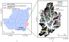
Fig.1
Location of study area and GF-2 image(4 m)"

Table 1
Number of training samples under different spatial resolutions of different units"
| 地物类型 Ground type | 像元水平(像元数量) Pixel level(number of pixels) | 对象水平(对象数量) Object level(number of objects) | |||
| 1 m | 4 m | 1 m | 4 m | ||
| 华北落叶松林Larix principis-rupprechtii | 41 053 | 3 003 | 235 | 68 | |
| 白桦林Betula platyphylla | 48 022 | 3 580 | 282 | 97 | |
| 灌草地Grass | 97 315 | 6 946 | 376 | 128 | |
| 裸地Bare | 36 301 | 2 705 | 208 | 81 | |
| 不透水地面Impervious surface | 52 993 | 3 972 | 568 | 147 | |
| 水体Water | 5 390 | 421 | 31 | 13 | |
Table 2
Parameters of image multiscale segmentation"
| 空间分辨率 Spatial resolution/m | 分割尺度 Segmentation scale | 形状参数 Shape parameter | 紧致度参数 Compactness parameter | 对象数量 Number of objects |
| 1 | 100 | 0.1 | 0.6 | 161 822 |
| 4 | 70 | 0.1 | 0.6 | 18 873 |
Table 3
Number of classification features at different spatial resolutions, feature sets and units"
| 空间分辨率 Spatial resolution | 特征数量 Number of features | 像元水平Pixel level | 对象水平Object level | ||||
| S | S+T | S | S+T | S+T+I | |||
| 1 m/4 m | 降维前Before dimensionality reduction | 4 | 4+32 | 18 | 18+40 | 18+40+6 | |
| 1 m | PCA后After PCA | 4 | 4+4 | 4 | 10 | 13 | |
| 4 m | PCA后After PCA | 4 | 4+4 | 3 | 12 | 15 | |
Table 4
Classification methods of different units"
| 像元水平Pixel level | 对象水平Object level | |||
| 分类算法Classification method | 参考文献Reference | 分类算法Classification method | 参考文献Reference | |
| 最大似然 Maximum likelihood(MLC) | 贝叶斯 Bayes | |||
| 马氏距离 Mahalanobis distance(MahaD) | k-最近邻 k-nearest neighbor(KNN) | Denoeux,1995 | ||
| 最小距离 Minimum distance(MiniD) | 决策树分类 Decision tree(DT) | |||
| 神经网络 Netural net(NN) | 随机森林 Random forest(RF) | |||
| 支持向量机 Support vector machine(SVM) | 支持向量机 Support vector machine(SVM) | |||
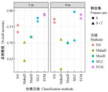
Fig.2
OA of 20 method combinations under different spatial resolutions and feature sets at pixel level"
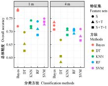
Fig.3
OA of 30 method combinations under different spatial resolutions and feature sets at object level"
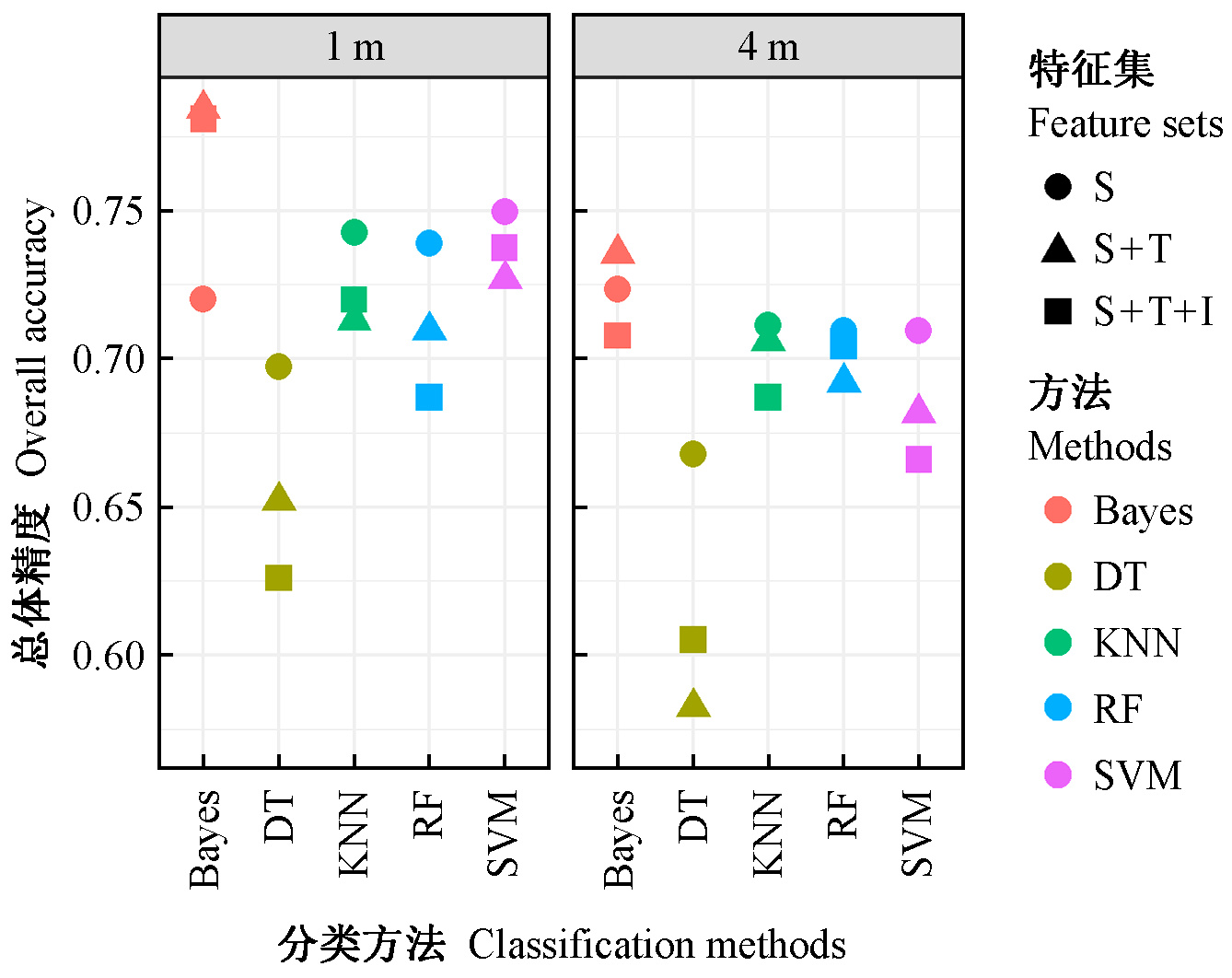

Fig.4
OA ranking and stratification number statistics for the top 25 method combinations"
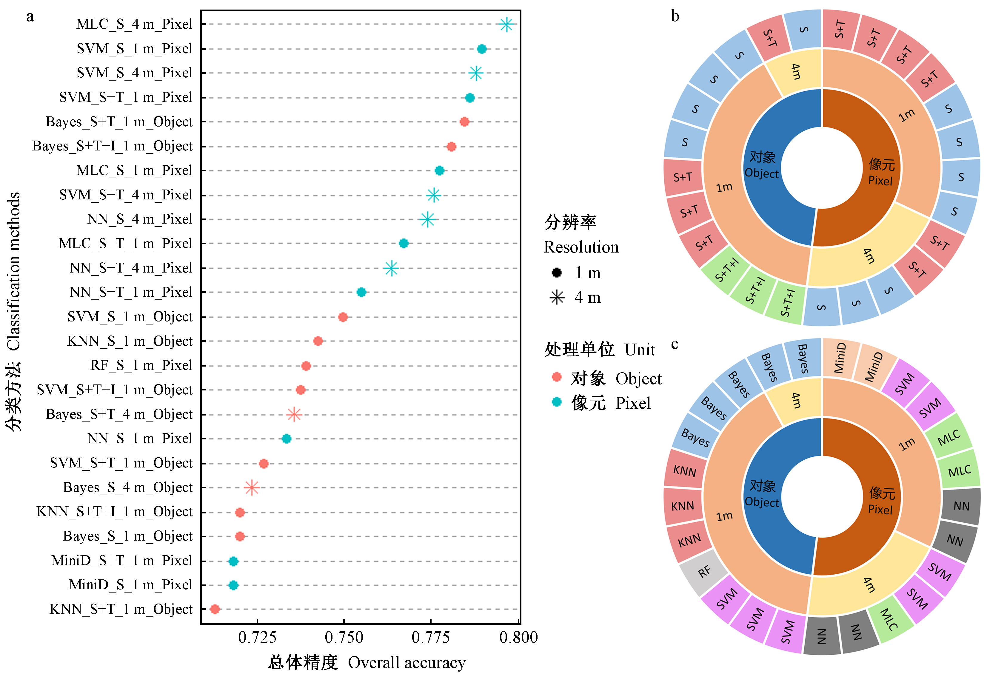
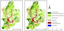
Fig.5
Classification results of optimal method combination at two units"

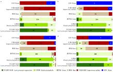
Fig.6
Confusion matrix of optimal method combination at two units a: Omission count of MLC_S_4 m_Pixel; b: Comission count of MLC_S_4 m_Pixel; c: Omission count of Bayes_S+T_1 m_Object; b: Comission count of Bayes_S+T_1 m_Object."

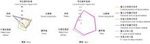
Fig.7
Commission and omission error of optimal method combination(%)(left) and F1-score(right) at two units"

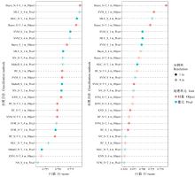
Fig.8
F1-score ranking of Larix principis-rupprechtii (left) and Betula platyphylla (right) for the top 25 method combinations"
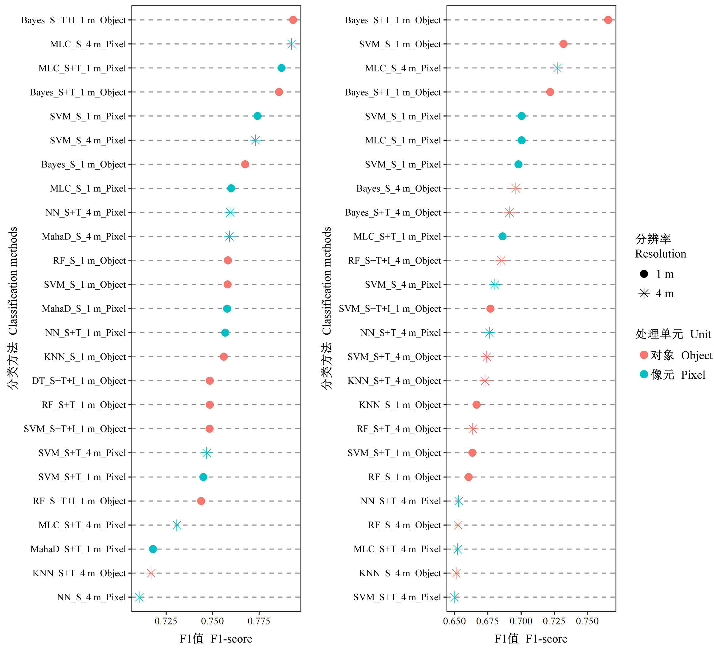
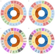
Fig.9
Stratification number statistics of Larix principis-rupprechtii(left) and Betula platyphylla (right) for the top 25 method combinations"

| 白娥, 薛冰. 土地利用与土地覆盖变化对生态系统的影响. 植物生态学报, 2020, 44 (5): 543- 552. | |
| Bai E , Xue B . A review of influences of land use and land cover change on ecosystems. Chinese Journal of Plant Ecology, 2020, 44 (5): 543- 552. | |
|
高海燕, 吴波. 结合像元形状特征分割的高分辨率影像面向对象分类. 遥感信息, 2010, (6): 67- 72.
doi: 10.3969/j.issn.1000-3177.2010.06.015 |
|
|
Gao H Y , Wu B . Object-oriented classification of high spatial resolution remote sensing imagery based on image segmentation with pixel shape feature. Remote Sensing Information, 2010, (6): 67- 72.
doi: 10.3969/j.issn.1000-3177.2010.06.015 |
|
|
韩鹏, 龚健雅. 遥感尺度选择问题研究进展. 遥感信息, 2008, (1): 96- 99.
doi: 10.3969/j.issn.1000-3177.2008.01.019 |
|
|
Han P , Gong J Y . A review on cholce of optimal scale in remote sensing. Remote Sensing Information, 2008, (1): 96- 99.
doi: 10.3969/j.issn.1000-3177.2008.01.019 |
|
| 郝虑远. 2014. 基于纹理分析的高分辨率影像面向对象分类研究. 北京: 北京师范大学. | |
| Hao L Y. 2014. Object-oriented classification of high-resolution images based on texture analysis. Beijing: Beijing Normal University. [in Chinese] | |
| 黄翀, 张晨晨, 刘庆生, 等. 结合光学与雷达影像多特征的热带典型人工林树种精细识别. 林业科学, 2021, 57 (7): 80- 91. | |
| Huang C , Zhang C C , Liu Q S , et al. Multi-feature classification of optical and SAR remote sensing images for typical tropical plantation species. Scientia Silvae Sinicae, 2021, 57 (7): 80- 91. | |
| 黄昕. 2009. 高分辨率遥感影像多尺度纹理、形状特征提取与面向对象分类研究. 武汉: 武汉大学. | |
| Huang X. 2009. Multiscale texture and shape feature extraction and object-oriented classification for very high resolution remotely sensed imagery. Wuhan: Wuhan University. [in Chinese] | |
| 李国清, 柏永青, 杨轩, 等. 基于深度学习的高分辨率遥感影像土地覆盖自动分类方法. 地球信息科学学报, 2021, 23 (9): 1690- 1704. | |
| Li G Q , Bai Y Q , Yang X , et al. Automatic deep learning land cover classification methods of high-resolution remotely sensed images. Journal of Geo-Information Science, 2021, 23 (9): 1690- 1704. | |
| 李宏达, 高小红, 汤敏. 基于CNN的不同空间分辨率影像土地覆被分类研究. 遥感技术与应用, 2020, 35 (4): 749- 758. | |
| Li H D , Gao X H , Tang M . Land cover classification for different spatial resolution images from CNN. Remote Sensing Technology and Application, 2020, 35 (4): 749- 758. | |
| 李哲, 张沁雨, 彭道黎. 基于高分二号遥感影像的树种分类方法. 遥感技术与应用, 2019, 34 (5): 970- 982. | |
| Li Z , Zhang Q Y , Peng D L . Classification method of tree species based on GF-2 remote sensing images. Remote Sensing Technology and Application, 2019, 34 (5): 970- 982. | |
|
栗旭升, 李虎, 陈冬花, 等. 联合GF-5与GF-6卫星数据的多分类器组合亚热带树种识别. 林业科学, 2020, 56 (10): 93- 104.
doi: 10.11707/j.1001-7488.20201010 |
|
|
Li X S , Li H , Chen D H , et al. Multiple classifiers combination method for tree species identification based on GF-5 and GF-6. Scientia Silvae Sinicae, 2020, 56 (10): 93- 104.
doi: 10.11707/j.1001-7488.20201010 |
|
|
刘金丽, 陈钊, 高金萍, 等. 高分影像树种分类的最优分割尺度确定方法. 林业科学, 2019, 55 (11): 95- 104.
doi: 10.11707/j.1001-7488.20191111 |
|
|
Liu J L , Chen Z , Gao J P , et al. Research on the method of determining the optimal segmentation scale for tree species classification of high-resolution image. Scientia Silvae Sinicae, 2019, 55 (11): 95- 104.
doi: 10.11707/j.1001-7488.20191111 |
|
| 刘思涵. 2020. 基于高分辨率影像纹理特征的华北落叶松人工林提取研究. 西安: 西安科技大学. | |
| Liu S H. 2020. Extraction of larch plantations using texture features within high spatial resolution images. Xi'an: Xi'an University of Science and Technology. [in Chinese] | |
| 明冬萍, 王群, 杨建宇. 遥感影像空间尺度特征与最佳空间分辨率选择. 遥感学报, 12 (4): 529- 537. | |
| Ming D P , Wang Q , Yang J Y . Spatial scale of remote sensing image selection of optimal spatial resolution. National Remote Sensing Bulletin, 2008, 12 (4): 529- 537. | |
| 牛志刚. 张家口市崇礼区围绕冬奥和创森强化生态修复实现全域生态面貌大提升. 河北林业, 2020, (12): 23- 24. | |
| Niu Z G . Chongli district of Zhangjiakou city has achieved a great improvement in the ecological outlook of the whole region by strengthening ecological restoration around the Winter Olympics and Chuangsen. Hebei Forestry, 2020, (12): 23- 24. | |
| 杨闫君, 田庆久, 占玉林, 等. 空间分辨率与纹理特征对多光谱遥感分类的影响. 地球信息科学学报, 2018, 20 (1): 99- 107. | |
| Yang Y J , Tian Q J , Zhan Y L , et al. Effects of spatial resolution and texture features on multi-spectral remote sensing classification. Journal of Geo-Information Science, 2018, 20 (1): 99- 107. | |
| 由珈齐, 李明泽, 范文义, 等. 基于高光谱和激光雷达数据的林分类型识别. 林业科学, 2021, 57 (5): 119- 129. | |
| You J Q , Li M Z , Fan W Y , et al. Stand type identification based on hyperspectral and LiDAR data. Scientia Silvae Sinicae, 2021, 57 (5): 119- 129. | |
| 周小成, 郑磊, 黄洪宇. 基于多特征优选的无人机可见光遥感林分类型分类. 林业科学, 2021, 57 (6): 24- 36. | |
| Zhou X C , Zheng L , Huang H Y , et al. Classification of forest stand based on multi-feature optimization of UAV visible light remote sensing. Scientia Silvae Sinicae, 2021, 57 (6): 24- 36. | |
|
Arowolo A O , Deng X Z , Olatunji O A , et al. Assessing changes in the value of ecosystem services in response to land-use/land-cover dynamics in Nigeria. The Science of the Total Environment, 2018, 636, 597- 609.
doi: 10.1016/j.scitotenv.2018.04.277 |
|
|
Bartholomé E , Belward A S . GLC2000: a new approach to global land cover mapping from Earth observation data. International Journal of Remote Sensing, 2005, 26 (9): 1959- 1977.
doi: 10.1080/01431160412331291297 |
|
|
Baumann M , Ozdogan M , Kuemmerle T , et al. Using the Landsat record to detect forest-cover changes during and after the collapse of the Soviet Union in the temperate zone of European Russia. Remote Sensing of Environment, 2012, 124, 174- 184.
doi: 10.1016/j.rse.2012.05.001 |
|
|
Belgiu M , Drǎguţ L . Random forest in remote sensing: a review of applications and future directions. ISPRS Journal of Photogrammetry and Remote Sensing, 2016, 114, 24- 31.
doi: 10.1016/j.isprsjprs.2016.01.011 |
|
| Blaschke T , Hay G J , Kelly M , et al. Geographic object-based image analysis-towards a new paradigm. ISPRS Journal of Photogrammetry and Remote Sensing, 2014, 87 (100): 180- 191. | |
|
Brovkin V , Boysen L , Arora V K , et al. Effect of anthropogenic land-use and land-cover changes on climate and land carbon storage in CMIP5 projections for the twenty-first century. Journal of Climate, 2013, 26 (18): 6859- 6881.
doi: 10.1175/JCLI-D-12-00623.1 |
|
|
Chen D , Stow D A , Gong P . Examining the effect of spatial resolution and texture window size on classification accuracy: an urban environment case. International Journal of Remote Sensing, 2004, 25 (11): 2177- 2192.
doi: 10.1080/01431160310001618464 |
|
|
Chen J , Chen J , Liao A , et al. Global land cover mapping at 30 m resolution: a POK-based operational approach. ISPRS Journal of Photogrammetry and Remote Sensing, 2015, 103, 7- 27.
doi: 10.1016/j.isprsjprs.2014.09.002 |
|
| Chen Y , Zhou Y , Ge Y , et al. Enhancing land cover mapping through integration of pixel-based and object-based classifications from remotely sensed imagery. Remote Sensing, 2018, 10 (1): 77. | |
|
Cross M , Scambos T , Pacifici F , et al. Classification of tropical forest tree species using meter-scale image data. Remote Sensing, 2019, 11 (12): 1411- 1159.
doi: 10.3390/rs11121411 |
|
| Denoeux T. 2008. A k-nearest neighbor classification rule based on Dempster-Shafer theory//Classic works of the Dempster-Shafer theory of belief functions. Springer, Berlin, Heidelberg, 737-760. | |
|
Du B , Zhang L . A discriminative metric learning based anomaly detection method. IEEE Transactions on Geoscience and Remote Sensing, 2014, 52 (11): 6844- 6857.
doi: 10.1109/TGRS.2014.2303895 |
|
|
Foody G M , Arora M K . An evaluation of some factors affecting the accuracy of classification by an artificial neural network. International Journal of Remote Sensing, 1997, 18 (4): 799- 810.
doi: 10.1080/014311697218764 |
|
|
Franklin S E , Wulder M A , Lavigne M B . Automated derivation of geographic window sizes for remote sensing digital image texture analysis. Computers and Geosciences, 1996, 22, 665- 673.
doi: 10.1016/0098-3004(96)00009-X |
|
|
Gong P , Liu H , Zhang M N , et al. Stable classification with limited sample: transferring a 30-m resolution sample set collected in 2015 to mapping 10-m resolution global land cover in 2017. Science Bulletin, 2019, 64 (6): 370- 373.
doi: 10.1016/j.scib.2019.03.002 |
|
| Gürkan A . A comparison of pixel based and object based approach for land use/land cover classification: a case study in Mediterranean region. The Journal of Scientific and Engineering Research, 2017, 48, 62- 67. | |
| Huang C , Davis L S , Townshend J R G . An assessment of support vector machines for land cover classification. International Journal of Remote Sensing, 2002, 23 (4): 725- 749. | |
| Jozdani S E , Johnson B A , Chen D . Comparing deep neural networks, ensemble classifiers, and support vector machine algorithms for object-based urban land use/land cover classification. Remote Sensing, 2019, 11 (14): 1713. | |
| Kannojia S P , Jaiswal G . Effects of varying resolution on performance of CNN based image classification: an experimental study. International Journal of Computer Sciences and Engineering, 2018, 6 (9): 451- 456. | |
| Liu D S , Xia F . Assessing object-based classification: advantages and limitations. Remote Sensing Letters, 2010, 1 (4): 187- 194. | |
| Liu Q , Huang C , Liu G , et al. Comparison of CBERS-04, GF-1, and GF-2 satellite panchromatic images for mapping quasi-circular vegetation patches in the Yellow River Delta, China. Sensors, 2018, 18 (8): 2733. | |
| Ma L , Li M , Ma X , et al. A review of supervised object-based land-cover image classification. ISPRS Journal of Photogrammetry and Remote Sensing, 2017, 130, 277- 293. | |
| Ma T , Li X , Bai J , et al. Four decades' dynamics of coastal blue carbon storage driven by land use/land cover transformation under natural and anthropogenic processes in the Yellow River Delta, China. Science of the Total Environment, 2019, 655, 741- 750. | |
| Mantyka-Pringle C S , Visconti P , Di Marco M , et al. Climate change modifies risk of global biodiversity loss due to land-cover change. Biological Conservation, 2015, 187, 103- 111. | |
| Maxwell A E , Warner T A , Fang F . Implementation of machine-learning classification in remote sensing: an applied review. International Journal of Remote Sensing, 2018, 39 (9): 2784- 2817. | |
| Mishra V N , Prasad R , Kumar P , et al. Dual-polarimetric C-band SAR data for land use/land cover classification by incorporating textural information. Environmental Earth Sciences, 2016, 76 (1): 1- 16. | |
| Mugiraneza T , Nascetti A , Ban Y . WorldView-2 data for hierarchical object-based urban land cover classification in Kigali: integrating rule-based approach with urban density and greenness indices. Remote Sensing, 2019, 11 (18): 2128. | |
| Qian Y , Zhou W , Yan J , et al. Comparing machine learning classifiers for object-based land cover classification using very high resolution imagery. Remote Sensing, 2015, 7 (1): 153- 168. | |
| Quinlan J R . Induction of decision trees. Machine Learning, 1986, 1 (1): 81- 106. | |
| Räsänen A , Virtanen T . Data and resolution requirements in mapping vegetation in spatially heterogeneous landscapes. Remote Sensing of Environment, 2019, 230, 111207. | |
| Pande-Chhetri R , Abd-Elrahman A , Liu T , et al. Object-based classification of wetland vegetation using very high-resolution unmanned air system imagery. European Journal of Remote Sensing, 2017, 50 (1): 564- 576. | |
| Shi L , Wan Y , Gao X , et al. Feature selection for object-based classification of high-resolution remote sensing images based on the combination of a genetic algorithm and tabu search. Computational Intelligence and Neuroscience, 2018, 6595792. | |
| Shrestha M , Acharya S C . Assessment of historical and future landuse-land-cover changes and their impact on valuation of ecosystem services in Kathmandu Valley, Nepal. Land Degradation & Development, 2021, 32 (13): 3731- 3742. | |
| Sisodia P S , Tiwari V , Kumar A . Analysis of supervised maximum likelihood classification for remote sensing image. International conference on recent advances and innovations in engineering, 2014, (ICRAIE-2014): 1- 4. | |
| Song M , Civco D L , Hurd J D . A competitive pixel-object approach for land cover classification. International Journal of Remote Sensing, 2005, 26 (22): 4981- 4997. | |
| Strahler A H . The use of prior probabilities in maximum likelihood classification of remotely sensed data. Remote Sensing of Environment, 1980, 10 (2): 135- 163. | |
| Stromann O , Nascetti A , Yousif O , et al. Dimensionality reduction and feature selection for object-based land cover classification based on Sentinel-1 and Sentinel-2 time series using Google Earth Engine. Remote Sensing, 2020, 12 (1): 76. | |
| Su B , Noguchi N . Discrimination of land use patterns in remote sensing image data using minimum distance algorithm and watershed algorithm. Engineering in Agriculture Environment & Food, 2013, 6 (2): 48- 53. | |
| Tab F A , Naghdy G , Mertins A . Scalable multiresolution color image segmentation. Signal Processing, 2006, 86 (7): 1670- 1687. | |
| Thanh Noi P , Kappas M . Comparison of random forest, k-nearest neighbor, and support vector machine classifiers for land cover classification using Sentinel-2 imagery. Sensors, 2018, 18 (1): 18. | |
| Tzotsos A, Argialas D. 2008. Support vector machine classification for object-based image analysis//Object-based image analysis. Springer, Berlin, Heidelberg, 663-677. | |
| Wang Z , Fan C , Xian M . Application and evaluation of a deep learning architecture to urban tree canopy mapping. Remote Sensing, 2021, 13 (9): 1749. | |
| Ye Q L , Huang P , Zhang Z , et al. Multiview learning with robust double-sided twin SVM. IEEE Transactions on Cybernetics, 2021, 3088519. | |
| Ye Q L , Li Z C , Fu L Y , et al. Nonpeaked discriminant analysis for data representation. IEEE Transactions on Neural Networks and Learning Systems, 2019, 30 (12): 3818- 3832. | |
| Yu L , Liang L , Wang J , et al. Meta-discoveries from a synthesis of satellite-based land-cover mapping research. International Journal of Remote Sensing, 2014, 35 (13): 4573- 4588. | |
| Zhang C , Wei S Q , Ji S P , et al. Detecting large-scale urban land cover changes from very high resolution remote sensing images using CNN-based classification. ISPRS International Journal of Geo-Information, 2019, 8 (4): 189. | |
| Zhang R , Tang X , You S , et al. A novel feature-level fusion framework using optical and SAR remote sensing images for land use/land cover(LULC) classification in cloudy mountainous area. Applied Sciences, 2020, 10 (8): 2928. | |
| Zhou W Q , Qian Y G , Li X M , et al. Relationships between land cover and the surface urban heat island: seasonal variability and effects of spatial and thematic resolution of land cover data on predicting land surface temperatures. Landscape Ecology, 2014, 29 (1): 153- 167. |
| Viewed | ||||||
|
Full text |
|
|||||
|
Abstract |
|
|||||