
Scientia Silvae Sinicae ›› 2022, Vol. 58 ›› Issue (4): 152-164.doi: 10.11707/j.1001-7488.20220416
• Research papers • Previous Articles Next Articles
Guofei Zhang,Wanqiu Zhang,Cairong Yue*
Received:2020-12-28
Online:2022-04-25
Published:2022-07-20
Contact:
Cairong Yue
CLC Number:
Guofei Zhang,Wanqiu Zhang,Cairong Yue. Forest Canopy Height Retrieval Based on TanDEM-X Data and Improved Three-Stage Inversion Algorithm[J]. Scientia Silvae Sinicae, 2022, 58(4): 152-164.
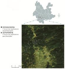
Fig.1
Location of study area (top) and plot distribution (bottom)"
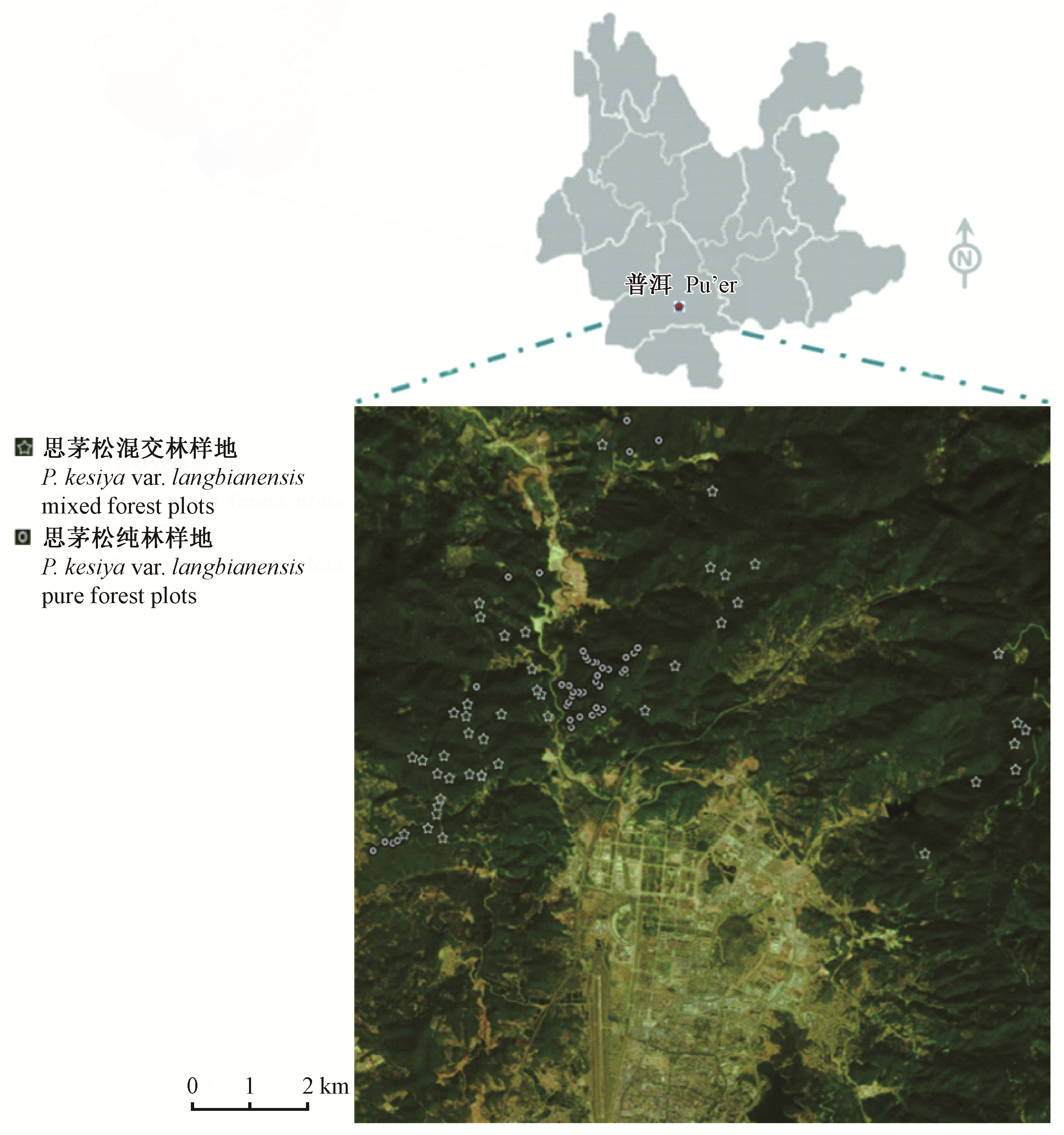
Table 1
Number and stand parameters of field plots"
| 森林类型 Forest types | 样地数量 Plot number | 林分参数 Stand parameters | 均值 Mean | 最大值 Max. | 最小值 Min. |
| 思茅松混交林 P. kesiya var. langbianensis mixed forests | 43 | 森林平均高度 Forest mean height/m | 17.3 | 24.0 | 13.2 |
| 郁闭度 Canopy density | 0.6 | 0.8 | 0.3 | ||
| 思茅松纯林 P. kesiya var. langbianensis pure forest | 47 | 森林平均高度 Forest mean height/m | 14.2 | 19.5 | 3.6 |
| 郁闭度 Canopy density | 0.5 | 0.6 | 0.3 |
Table 2
Description of SAR data"
| 卫星Satellite | TSX-1/ TDX-1 |
| 获取日期Date of acquisition | 2015-10-06 |
| 极化方式Polarization | 全极化Complete polarization |
| 波段Band | X |
| 分辨率Resolution/m | 2.71 |
| 中心入射角Center angle of incidence/(°) | 39.67 |
| 基线Effective baseline/m | 361.37 |
| 升/降轨Ascending/descending | 降轨Descending |
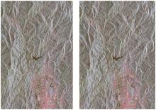
Fig.2
Pauli colour composite of master (left) and slave (right) images"


Fig.3
RVoG model"

Fig.4
Main procedures for the four different methods"

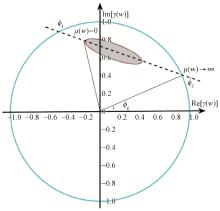
Fig.5
The geometrical representation of coherence line inside the complex unit circle"
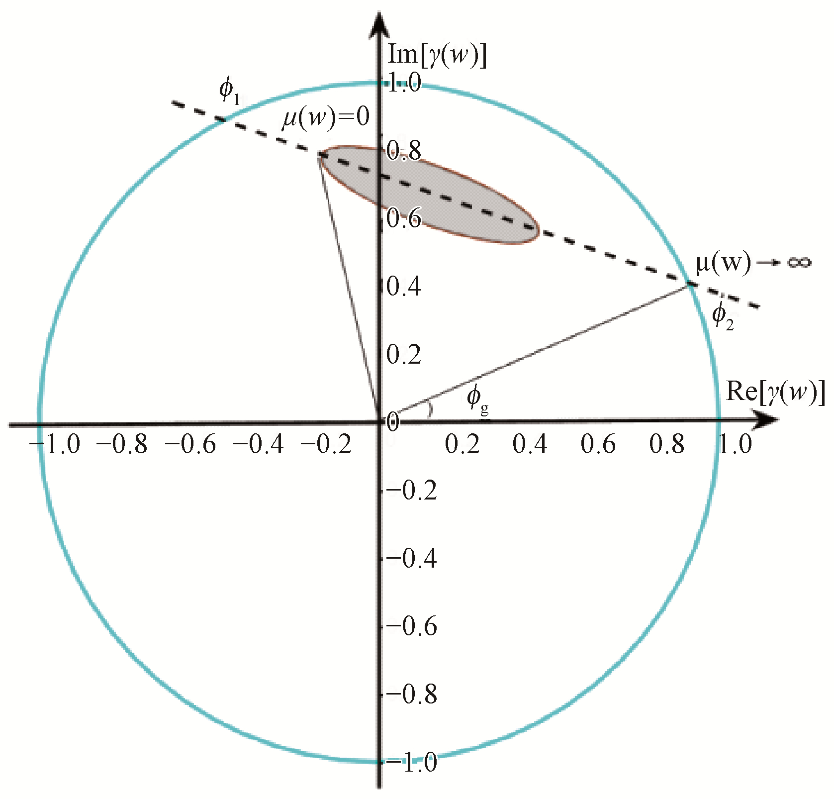
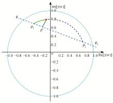
Fig.6
The projection of unchanged module of complex coherence"
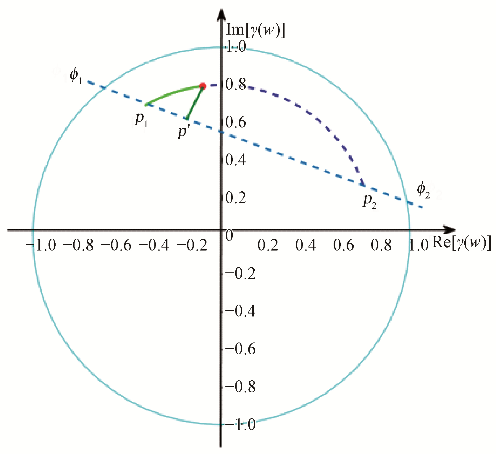
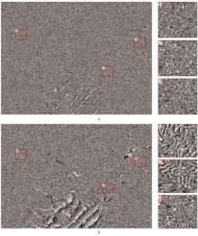
Fig.7
Estimated ground phase of study area"

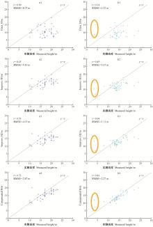
Fig.8
The scatter plots between estimation heights and measured heights a1, a2, a3 and a4: plots in P. kesiya var. langbianensis mixed forests; b1, b2, b3 and b4: plots in P. kesiya var. langbianensis pure forest; the plots in orange circle is young P. kesiya var. langbianensis forest."

Table 3
Validation results of the three-stage inversion algorithm from all approaches"
| 方法Methods | 评价指标Validation index | 思茅松混交林样地P. kesiya var. langbianensis mixed forest plots | 思茅松纯林样地P. kesiya var. langbianensis pure forest plots | 所有样地All plots |
| 方法1 Method 1 | r | 0.09 | 0.14 | 0.11 |
| bias/m | -15.40 | -10.80 | -26.20 | |
| RMSE/m | 8.07 | 6.32 | 7.16 | |
| RMSE (%) | 56.70 | 44.64 | 45.82 | |
| 方法2 Method 2 | r | 0.45 | 0.49 | 0.46 |
| bias /m | -6.44 | -2.75 | -9.19 | |
| RMSE/m | 4.40 | 3.65 | 4.00 | |
| RMSE (%) | 25.79 | 25.49 | 25.60 | |
| 方法3 Method 3 | r | 0.55 | 0.64 | 0.62 |
| bias /m | -6.01 | -2.30 | -7.31 | |
| RMSE/m | 4.07 | 3.11 | 3.57 | |
| RMSE (%) | 17.76 | 17.77 | 17.77 | |
| 方法4 Method 4 | r | 0.72 | 0.81 | 0.79 |
| bias /m | -3.09 | 1.40 | -1.69 | |
| RMSE/m | 2.87 | 2.27 | 2.56 | |
| RMSE (%) | 16.62 | 16.04 | 16.37 |
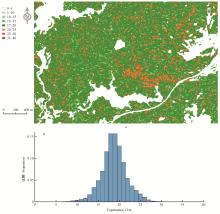
Fig.9
Predicted maps(parts) of Compensated_H in the study area"

| 陈兵, 徐绍剑, 张平. 单基线PolInSAR反演算法研究. 电子与信息学报, 2008, 30 (7): 1744- 1746. | |
| Chen B , Xu S J , Zhang P . Research on the single-baseline PolInSAR inversion algorithms. Journal of Electronics & Information Technology, 2008, 30 (7): 1744- 1746. | |
| 范亚雄, 陈尔学, 李增元, 等. 基于TanDEM-X相干系数的森林高度估测方法. 林业科学, 2020, 56 (6): 35- 46. | |
| Fan Y X , Chen E X , Li Z Y , et al. Forest height estimation method using TanDEM-X interferometric coherence data. Scientia Silvae Sinicae, 2020, 56 (6): 35- 44. | |
| 冯琦, 陈尔学, 李增元, 等. 机载X-波段双天线InSAR数据森林树高估测方法. 遥感技术与应用, 2016, 31 (3): 551- 557. | |
| Feng Q , Chen E X , Li Z Y , et al. Forest height estimation from airborne X-band single-pass InSAR data. Remote Sensing Technology and Application, 2016, 31 (3): 551- 557. | |
| 李江. 2011. 思茅松中幼龄人工林生物量和碳储量动态研究. 北京: 北京林业大学. | |
| Li J. 2011. Dynamic changes of biomass and carbon storage in Pinus kesiya var. langbianensis forest. Beijing: Beijing Forestry University. [in Chinese] | |
|
李廷伟, 梁甸农, 朱炬波. 极化干涉SAR森林高度反演综述. 遥感信息, 2009, (3): 85- 91.
doi: 10.3969/j.issn.1000-3177.2009.03.019 |
|
|
Li T W , Liang D N , Zhu J B . A review of inversion of the forest height by polarimetric interferometric SAR. Remote Sensing Information, 2009, (3): 85- 91.
doi: 10.3969/j.issn.1000-3177.2009.03.019 |
|
| 廖展芒. 2019. 森林地上生物量极化干涉SAR反演方法研究. 成都: 电子科技大学. | |
| Liao Z M. 2019. Forest aboveground biomass estimation using PolInSAR data. Chengdu: University of electronic Science and Technology of China. [in Chinese] | |
| 解清华, 汪长城, 朱建军, 等. 顾及地形因素的S-RVOG模型和PD相干最优算法联合反演植被高度. 测绘学报, 2015, 44 (6): 686- 693.686-693, 701 | |
| Xie Q H , Wang C C , Zhu J J , et al. Forest height inversion by combining S-RVOG model with terrain factor and PD coherence optimization. Acta Geodaetica et Cartographica Sinica, 2015, 44 (6): 686- 693.686-693, 701 | |
| 云南省林业调查规划院. 2016. 云南省思茅区森林资源规划设计调查报告. 昆明: 资源调查报告. | |
| Yunnan forestry survey and Planning Institute. 2016. Investigation report on forest resources planning and design in Simao District, Yunnan Province. Kunming: Resource survey report. [in Chinese]) | |
| 章皖秋. 2018. 基于TanDEM-X SAR数据的森林冠层高度估测. 昆明: 西南林业大学. | |
| Zhang W Q. 2018. Estimation of forest canopy height based on TanDEM-X polarimetric and interferometric SAR data. Kunming: Southwest Forestry University. [in Chinese] | |
|
Bamler R , Hartl P . Synthetic aperture radar interferometry. Inverse Problems, 1998, 14 (4): R1.
doi: 10.1088/0266-5611/14/4/001 |
|
| Caicoya A T , Kugler F , Hajnsek I , et al. Boreal forest biomass classification with TanDEM-X. International Geoscience and Remote Sensing Symposium (IGARSS), 2012, 3439- 3442. | |
| Chen J H , Zhang H , Wang C , et al. Forest model for height estimation using PolInSAR data. Progress in Electromagetics Research Symposium Proceedings, Suzhou China, 2011, 1931- 1934. | |
| Cloude S R. 2003. PolInSAR regularization using dual frequency interferometry. Proceedings of the International Conference on Radar(IEEE Cat. No. 03EX695), Adelaide, SA, Australia, 92-97. | |
| Cloude S R . Polarsisation: applications in remote sensing. Beijing: Electronic Industry Press, 2015. | |
|
Cloude S R , Papathanssiou K P . PolariInetric SAR interferometry. IEEE Transations on Geoscience and Remote Sensing, 1998, 36 (5): 1551- 1565.
doi: 10.1109/36.718859 |
|
| Denbina M, Simard M. 2016. The effects of temporal decorrelation and topographic slope on forest height retrieval using airborne repeat-pass L-band polarmetric SAR interferometry. Proceedings of 2016 IEEE International Geoscience and Remote Sensing Symposium(IGARSS 2016), Beijing, China, 1745-1748. | |
| Flynn T , Tabb M , Carande R . Direct estimation of vegetation parameters from covariance data in polarimetric SAR interferometry. International Geoscience and Remote Sensing Symposium (IGARSS), 2002, 3, 1908- 1910. | |
|
Garestier F , Dubois-Fernandez P C , Champion I . Forest height inversion using high resolution P-band PolInSAR data. IEEE Transaction on Geoscience and Remote Sensing, 2008, 46 (11): 3544- 3559.
doi: 10.1109/TGRS.2008.922032 |
|
| Garestier F , le Toan T . Vegetation modelling for height inversion using InSAR/Pol-InSAR data. International Geoscience and Remote Sensing Symposium (IGARSS), 2007, 2322- 2325. | |
| Hajnsek I , Kugler F , Seungkuk L , et al. Tropical-forest-parameter estimation by means of PolInSAR: the INDREX-II campaign. IEEE Transactions on Geoscience & Remote Sensing, 2009, 47 (2): 481- 493. | |
| Khati U, Singh G. 2015. Bistatic PolInSAR for forest height estimation: results from TanDEM-X. 2015 IEEE 5th Asia-Pacific Conference on Synthetic Aperture Radar, Singapore, 213-216. | |
|
Krieger G , Moreira A , Fiedler H , et al. TanDEM-X: a satellite formation for high-resolution SAR interferometry. IEEE Transactions on Geoscience and Remote Sensing, 2007, 45 (11): 3317- 3340.
doi: 10.1109/TGRS.2007.900693 |
|
|
Kugler F , Lee S , Hajnsek I . Forest height estimation by means of PolInSAR data inversion: the role of the vertical wavenumber. IEEE Transactions on Geoscience and Remote Sensing, 2015, 53 (10): 1- 18.
doi: 10.1109/TGRS.2015.2478083 |
|
|
Kumar S , Garg R D , Kushwaha S P S , et al. Bistatic PolInSAR inversion modelling for plant height retrieval in a tropical forest. Proceedings of the National Academy of Sciences, India Section A: Physical Sciences, 2017, 87 (4): 817- 826.
doi: 10.1007/s40010-017-0451-9 |
|
|
Lu H , Suo Z , Guo R , et al. S-RVoG model for forest parameters inversion over underlying topography. Electronics Letters, 2013, 49 (9): 618- 619.
doi: 10.1049/el.2012.4467 |
|
| Minh N P . Slope three-layer scattering model for forest height estimation over mountain forest areas from L-band single-baseline PolInSAR data. Journal of Applied Remote Sensing, 2020, 12 (2): 1. | |
|
Minh N P , Wang C , Zou B , et al. Forest height extraction from PolInSAR image using a hybrid method. International Journal of Signal Processing Image Processing and Pattern Recognition, 2014, 7 (2): 257- 274.
doi: 10.14257/ijsip.2014.7.2.24 |
|
|
Papathanassiou K P , Cloude S R . Single-baseline polarimetric SAR interferometry. IEEE Transactions on Geoscience and Remote Sensing, 2001, 39 (11): 2352- 2362.
doi: 10.1109/36.964971 |
|
| Parks J, Demirpolat C, Antropov O, et al. 2013. On forest height retrieval from spaceborne X-band interferometric SAR images under variable seasonal conditions. XXXIII Finnish URSI Convention on Radio Science and SMARAD Seminar 2013, 115-118. | |
|
Sadeghi Y , St-Onge B , Leblon B , et al. Canopy height model (CHM) derived from a TanDEM-X InSAR DSM and an airborne LiDAR DTM in boreal forest. IEEE Journal of Selected Topics in Applied Earth Observations and Remote Sensing, 2016, 9 (1): 381- 397.
doi: 10.1109/JSTARS.2015.2512230 |
|
|
Sexton J O , Bax T , Siqueira P , et al. A comparison of lidar, radar, and field measurements of canopy height in pine and hardwood forests of southeastern North America. Forest Ecology and Management, 2009, 257 (3): 1136- 1147.
doi: 10.1016/j.foreco.2008.11.022 |
|
|
Treuhaft R N , Cloude S R . The structure of oriented vegetation from polarimetric interferometry. IEEE Transaction on Geoscience and Remote Sensing, 1999, 37 (5): 2620- 2624.
doi: 10.1109/36.789657 |
|
|
Treuhaft R N , Madsen S N , Moghaddam M , et al. Vegetation characteristics and underlying topography from interferometric radar. Radio Science, 1996, 31 (6): 1449- 1485.
doi: 10.1029/96RS01763 |
|
|
Treuhaft R N , Siqueira P R . Vertical structure of vegetated land surfaces from interferometric and polarimetric radar. Radio Science, 2000, 35 (1): 141- 177.
doi: 10.1029/1999RS900108 |
| [1] | Yaxiong Fan,Erxue Chen,Zengyuan Li,Lei Zhao,Wangfei Zhang,Yudong Jin,Lijie Cai. Forest Height Estimation Method Using TanDEM-X Interferometric Coherence Data [J]. Scientia Silvae Sinicae, 2020, 56(6): 35-46. |
| [2] | Qiu Sai, Xing Yanqiu, Tian Jing, Ding Jianhua. Forest Canopy Height Estimation of Large Area Using Spaceborne LIDAR and HJ-1A/HSI Hyperspectral Imageries [J]. Scientia Silvae Sinicae, 2016, 52(5): 142-149. |
| Viewed | ||||||
|
Full text |
|
|||||
|
Abstract |
|
|||||