
Scientia Silvae Sinicae ›› 2021, Vol. 57 ›› Issue (5): 184-194.doi: 10.11707/j.1001-7488.20210518
• Scientific notes • Previous Articles Next Articles
Danni Zhang,Xiya Chen,Chuanfu Zang*
Received:2019-02-11
Online:2021-05-25
Published:2021-07-09
Contact:
Chuanfu Zang
CLC Number:
Danni Zhang,Xiya Chen,Chuanfu Zang. Potential for Afforestation in the Three-North Region Where Implements Shelter-Belt Forest Program[J]. Scientia Silvae Sinicae, 2021, 57(5): 184-194.
Table 1
Evaluation indicators of soil type"
| 土纲 Order of soil | 宜林性 Suitability of afforestation | 不宜林原因 Reasons | 量化 Quantification |
| 淋溶土 Luvisols | 是 Yes | — | 1 |
| 半淋溶土 Semi-luvisols | 是 Yes | — | 1 |
| 钙层土 Pedocal | 是 Yes | — | 1 |
| 干旱土 Xerosol | 是 Yes | — | 1 |
| 初育土 Primary soil | 是 Yes | — | 1 |
| 半水成土 Semi-hydromorphic soil | 是 Yes | — | 1 |
| 水成土 Hydromorphic soil | 是 Yes | — | 1 |
| 盐碱土 Saline-alkali soil | 否 No | 造林效益低( Low afforestation benefit( | 0 |
| 人为土 Anthrosol | 是 Yes | — | 1 |
| 高山土 High mountain soil | 否 No | 热量不足( Insufficient heat( | 0 |
| 西北盐壳 Salt crust | 否 No | 造林效益低( Low afforestation benefit( | 0 |
Table 2
Evaluation indicators of land use type"
| 土地利用类型 Land use type | 宜林性 Suitability of afforestation | 不宜林原因 Reasons | 量化 Quantification |
| 水田 Paddy field | 否 No | 我国对基本农田实行特殊保护 Special protection for basic farmland | 0 |
| 旱地 Dry farm | 是 Yes | — | 1 |
| 有林地 Woodland | 否 No | 已有林地 Existing forest | 0 |
| 灌木林 Shrub | 是 Yes | — | 1 |
| 疏林地 Sparse woodland | 是 Yes | — | 1 |
| 其他林地 Other woodland | 是 Yes | — | 1 |
| 高覆盖度草地 High coverage grass | 否 No | 我国对基本草原实行特殊保护 Special protection for basic grassland | 0 |
| 中覆盖度草地 Medium coverage grass | 是 Yes | — | 1 |
| 低覆盖度草地 Low coverage grass | 是 Yes | — | 1 |
| 河渠 River and channel | 否 No | 水体 Water | 0 |
| 湖泊 Lake | 否 No | 水体 Water | 0 |
| 水库坑塘 Reservoir and pond | 否 No | 水体 Water | 0 |
| 永久性冰川雪地 Permanent glacier and snow | 否 No | 常年被冰川和积雪所覆盖 Covered by glaciers and snow | 0 |
| 滩地 Shoal | 是 Yes | — | 1 |
| 沼泽地 Wetlands | 是 Yes | — | 1 |
| 城镇用地 Urban land | 否 No | 聚落生态系统 Settlement ecosystem | 0 |
| 农村居民点 Rural settlement | 否 No | 聚落生态系统 Settlement ecosystem | 0 |
| 其他建设用地 Other construction land | 否 No | 聚落生态系统 Settlement ecosystem | 0 |
| 沙地 Sandy land | 是 Yes | — | 1 |
| 戈壁 Gobi | 是 Yes | — | 1 |
| 盐碱地 Saline-alkali land | 是 Yes | — | 1 |
| 裸土地 Bare land | 是 Yes | — | 1 |
| 裸岩石质地 Bare rock land | 否 No | 土壤厚度不足 Insufficient soil thickness | 0 |
| 其他 Other unused land | 否 No | 分布地气候恶劣 Harsh climate | 0 |
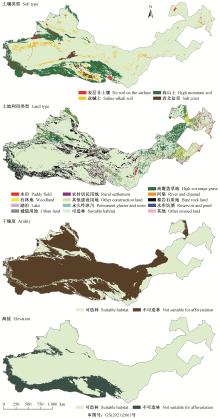
Fig.1
Afforestation suitability results based on single-index assessment"


Fig.2
Afforestation suitability result based on integrated assessment Area suitable for afforestation is concentrated in elliptical region"
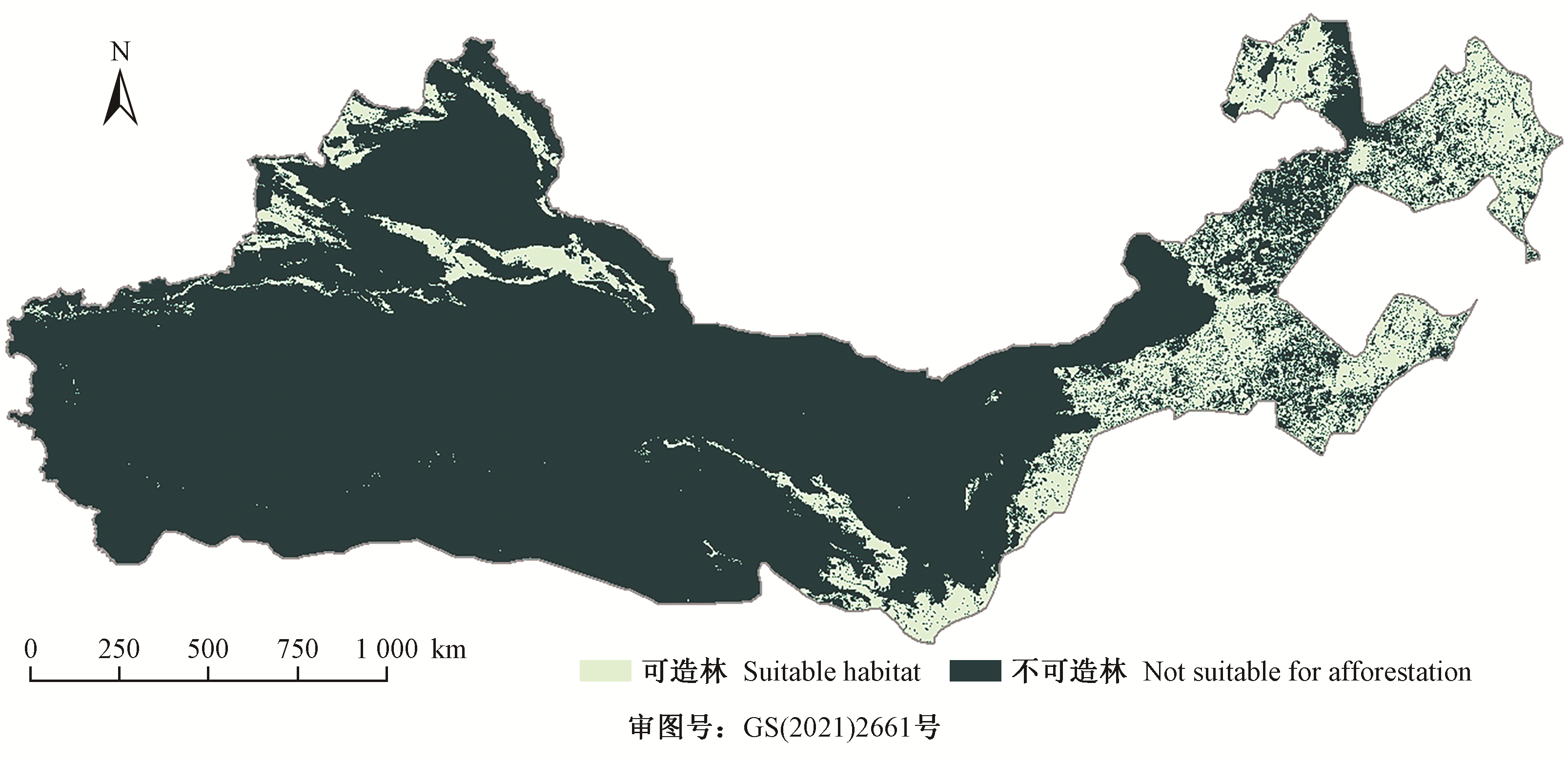
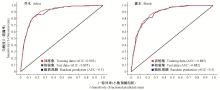
Fig.3
ROC by MaxEnt model"
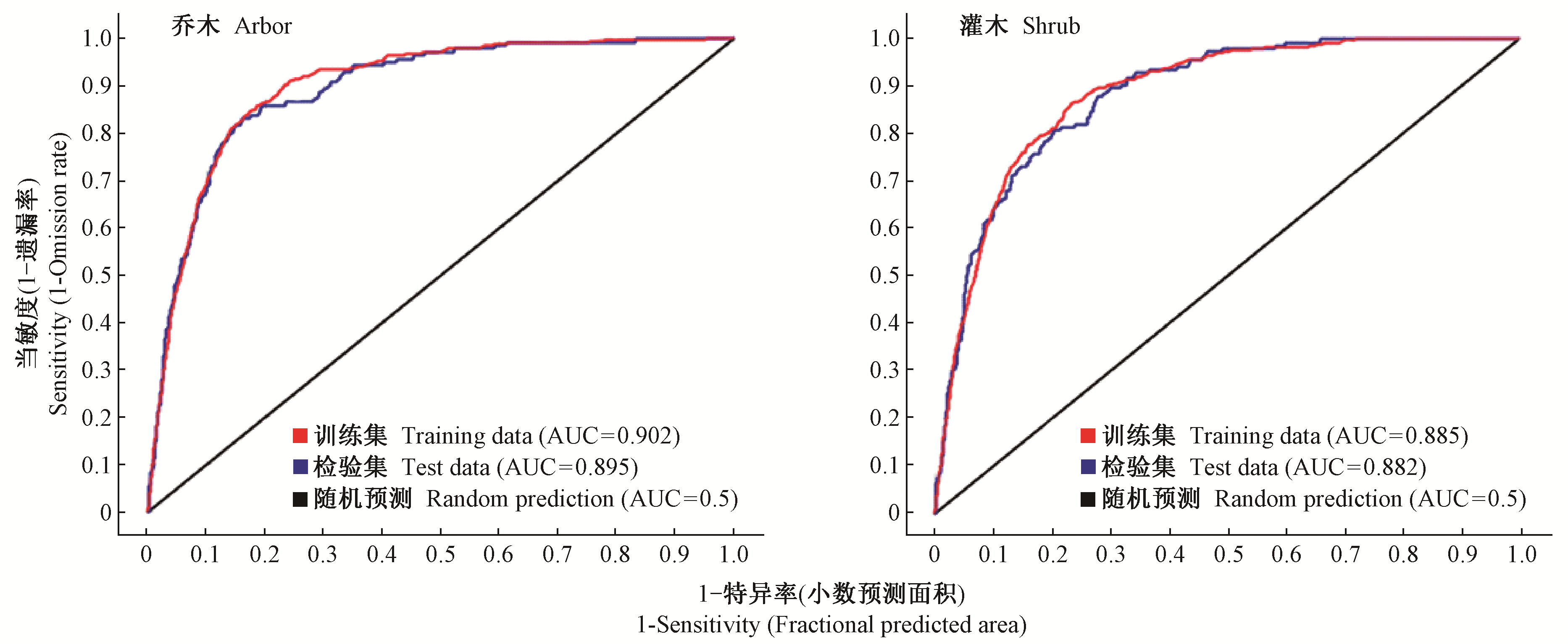
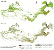
Fig.4
Predicted distribution of suitable habitat of arbor and shrub by MaxEnt model"

| 陈亚宁, 李卫红, 陈亚鹏, 等. 荒漠河岸林建群植物的水分利用过程分析. 干旱区研究, 2018, 35 (1): 130- 136. | |
| Chen Y N , Li W H , Chen Y P , et al. Water use process of constructive plants in desert riparian forest. Arid Zone Research, 2018, 35 (1): 130- 136. | |
| 高若楠, 苏喜友, 谢阳生, 等. 基于随机森林的杉木适生性预测研究. 北京林业大学学报, 2017, 39 (12): 36- 43. | |
| Gao R N , Su X Y , Xie Y S , et al. Prediction of adaptability of Cunninghamia lanceolata based on random forest. Journal of Beijing Forestry University, 2017, 39 (12): 36- 43. | |
| 高以信. 我国高山土壤分类研究的进展. 山地学报, 1990, 8 (1): 9- 18. | |
| Gao Y X . Progress in the study of the classification of high mountain soils in China. Mountain Research, 1990, 8 (1): 9- 18. | |
| 韩忆楠, 彭建, 王仰麟. 基于自组织特征映射(SOFM)网络的农牧交错带景观分区——以内蒙古自治区为例. 应用生态学报, 2013, 24 (5): 1224- 1230. | |
| Han Y N , Peng J , Wang Y L . Landscape regionalization of agro-pastoral transitional zone using self-organizing feature maps (SOFM) network: a case study of Inner Mongolia Autonomous Region, Chinese. Journal of Applied Ecology, 2013, 24 (5): 1224- 1230. | |
| 黄麟, 祝萍, 肖桐, 等. 近35年三北防护林体系建设工程的防风固沙效应. 地理科学, 2018, 38 (4): 600- 609. | |
| Huang L , Zhu P , Xiao T , et al. The sand fixation effects of Three-North Shelter Forest Program in recent 35 years. Scientia Geographica Sinica, 2018, 38 (4): 600- 609. | |
|
雷相东, 符利勇, 李海奎, 等. 基于林分潜在生长量的立地质量评价方法与应用. 林业科学, 2018, 54 (12): 116- 126.
doi: 10.11707/j.1001-7488.20181213 |
|
|
Lei X D , Fu L Y , Li H K , et al. Methodology and applications of site quality assessment based on potential mean annual increment. Scientia Silvae Sinicae, 2018, 54 (12): 116- 126.
doi: 10.11707/j.1001-7488.20181213 |
|
|
林玉英, 胡喜生, 邱荣祖, 等. 基于Landsat影像的NDVI对植被与影响因子交互耦合的响应. 农业机械学报, 2018, 49 (10): 212- 219.
doi: 10.6041/j.issn.1000-1298.2018.10.024 |
|
|
Lin Y Y , Hu X S , Qiu R Z , et al. Responses of landsat-based NDVI to interaction of vegetation and influencing factors. Transactions of the Chinese Society for Agricultural Machinery, 2018, 49 (10): 212- 219.
doi: 10.6041/j.issn.1000-1298.2018.10.024 |
|
| 刘冰, 龚维, 宫文宁, 等. 三北防护林体系建设面临的机遇和挑战. 生态学杂志, 2009, 28 (9): 1679- 1683. | |
| Liu B , Gong W , Gong W N , et al. Opportunities and challenges in the construction of the Three-North Shelterbelt Program. Chinese Journal of Ecology, 2009, 28 (9): 1679- 1683. | |
| 刘丹, 李玉堂, 洪玲霞. 基于最大熵模型的吉林省主要天然林潜在分布适宜性. 林业科学, 2018, 54 (7): 1- 15. | |
| Liu D , Li Y T , Hong L X , et al. The suitability of potential geographic distribution of natural forest types in Jilin Province based on maximum entropy models. Scientia Silvae Sinicae, 2018, 54 (7): 1- 15. | |
| 刘军会, 高吉喜. 气候和土地利用变化对中国北方农牧交错带植被覆盖变化的影响. 应用生态学报, 2008, 19 (9): 2016- 2022. | |
| Liu J H , Gao J X . Effects of climate and land use change on the changes of vegetation coverage in farming-pastoral ecotone of Northern China. Chinese Journal of Applied Ecology, 2008, 19 (9): 2016- 2022. | |
| 卢娜. 柴达木盆地湖泊面积变化及影响因素分析. 干旱区资源与环境, 2014, 28 (8): 83- 87. | |
| Lu N . Changes of lake area in Qaidam basin and the influence factors. Journal of Arid Land Resources and Environment, 2014, 28 (8): 83- 87. | |
| 马林. 草原生态保护红线划定的基本思路与政策建议. 草地学报, 2014, 22 (2): 229- 233. | |
| Ma L . Basic thoughts and policy suggestions of delimiting grassland ecological protection red line. Acta Agrestia Sinica, 2014, 22 (2): 229- 233. | |
|
孟猛, 倪健, 张治国. 地理生态学的干燥度指数及其应用评述. 植物生态学报, 2004, 28 (6): 853- 861.
doi: 10.3321/j.issn:1005-264X.2004.06.015 |
|
|
Meng M , Ni J , Zhang Z G . Aridity index and its applications in geo-ecological study. Acta Phytoecologica Sinica, 2004, 28 (6): 853- 861.
doi: 10.3321/j.issn:1005-264X.2004.06.015 |
|
|
邵全琴, 樊江文, 刘纪远, 等. 重大生态工程生态效益监测与评估研究. 地球科学进展, 2017, 32 (11): 1174- 1182.
doi: 10.11867/j.issn.1001-8166.2017.11.1174 |
|
|
Shao Q Q , Fan J W , Liu J Y , et al. Approaches for monitoring and assessment of ecological benefits of national key ecological projects. Advances in Earth Science, 2017, 32 (11): 1174- 1182.
doi: 10.11867/j.issn.1001-8166.2017.11.1174 |
|
| 沈维, 张林, 罗天祥. 高山林线变化的更新受限机制研究进展. 生态学报, 2017, 37 (9): 2858- 2868. | |
| Shen W , Zhang L , Luo T X . Advances in the study of the limitations of seedling recruitment for alpine timberline forests. Acta Ecologica Sinica, 2017, 37 (9): 2858- 2868. | |
| 孙然好, 张百平. 地形和气候对中国山地森林带界线的影响. 地理科学, 2016, 33 (2): 167- 173. | |
| Sun R H , Zhang B P . Effect of regional topographic and climatic factors on limits of altitudinal forest belts. Scientia Geographica Sinica, 2016, 33 (2): 167- 173. | |
|
王襄平, 张玲, 方精云. 中国高山林线的分布高度与气候的关系. 地理学报, 2004, 59 (6): 871- 879.
doi: 10.3321/j.issn:0375-5444.2004.06.009 |
|
|
Wang X P , Zhang L , Fang J Y . Geographical differences in alpine timberline and its climatic interpretation in China. Acta Geographica Sinica, 2004, 59 (6): 871- 879.
doi: 10.3321/j.issn:0375-5444.2004.06.009 |
|
| 王洋, 魏加华, 解宏伟. 基于GRACE的柴达木盆地水储量变化. 南水北调与水利科技, 2018, 16 (1): 91- 98. | |
| Wang Y , Wei J H , Xie H W . Study on the variation of terrestrial water storage in the Qaidam basin based on GRACE data. South-to-North Water Transfers and Water Science & Technology, 2018, 16 (1): 91- 98. | |
| 位姗姗, 王洋, 于飞. 林线更新关键影响因子研究进展. 生态学杂志, 2019, 38 (11): 3535- 3541. | |
| Wei S S , Wang Y , Yu F . Research advances in key factors affecting seedling regeneration above treeline. Chinese Journal of Ecology, 2019, 38 (11): 3535- 3541. | |
| 魏天兴, 王晶晶. 黄土区蔡家川流域河岸林物种多样性研究. 北京林业大学学报, 2009, 31 (6): 49- 53. | |
| Wei T X , Wang J J . Diversity of riparian vegetation in the Caijiachuan Watershed of the Loess Plateau, southwestern Shanxi Province, northern China. Journal of Beijing Forestry University, 2009, 31 (6): 49- 53. | |
| 吴泠, 张新时. 松嫩平原农牧交错区牧草资源特点及畜牧业发展. 生态学报, 2004, 26 (2): 601- 609. | |
| Wu L , Zhang X S . Characters of forage resources and the development of pastoral industry in the farming pastoral zone of the Songnen Plain. Acta Ecologica Sinica, 2004, 26 (2): 601- 609. | |
| 于晓华, 方创琳, 罗奎. 丝绸之路经济带陆路边境口岸城市地缘战略优势度综合评估. 干旱区地理, 2016, 39 (5): 967- 978. | |
| Yu X H , Fang C L , Luo K . Integrated evaluation of the advantage value of geopolitical strategy of frontier port cities under the background of the Silk Road Economic Belt. Arid Land Geography, 2016, 39 (5): 967- 978. | |
|
张川红, 沈应柏, 尹伟伦, 等. 盐胁迫对几种苗木生长及光合作用的影响. 林业科学, 2002, 38 (2): 27- 31.
doi: 10.3321/j.issn:1001-7488.2002.02.006 |
|
|
Zhang C H , Shen Y B , Yin W L . Effect of salt stress on photosynthesis and growth of four tree species seedling. Scientia Silvae Sinicae, 2002, 38 (2): 27- 31.
doi: 10.3321/j.issn:1001-7488.2002.02.006 |
|
| 张学玲, 张莹, 牛德奎, 等. 基于TMNDVI的武功山山地草甸植被覆盖度时空变化研究. 生态学报, 2018, 38 (7): 2414- 2424. | |
| Zhang X L , Zhang Y , Niu D K , et al. Spatial-temporal dynamics of upland meadow coverage on Wugong Mountain based on TM NDVI. Acta Ecologica Sinica, 2018, 38 (7): 2414- 2424. | |
|
Bohacz J . Species diversity of keratinophilic fungi in various soil types. Open Life Sciences, 2012, 7 (2): 259- 266.
doi: 10.2478/s11535-012-0008-5 |
|
|
Cao S X , Chen L , Shankman D , et al. Excessive reliance on afforestation in China's arid and semi-arid regions: lessons in ecological restoration. Earth-Science Reviews, 2011, 104 (4): 240- 245.
doi: 10.1016/j.earscirev.2010.11.002 |
|
|
Chung I M , Kim J K , Yang J H , et al. Effects of soil type and organic fertilizers on fatty acids and vitamine in Korean ginseng (Panax ginseng Meyer). Food Research International, 2017, 102, 265- 273.
doi: 10.1016/j.foodres.2017.10.003 |
|
| de Martonne E . The aridity index. Bulletin of the Association of French Geographers, 1926, 3 (9): 3- 5. | |
|
Elith J , Phillips S J , Hastie T , et al. A statistical explanation of maxent for ecologists. Diversity and Distributions, 2011, 17 (1): 43- 57.
doi: 10.1111/j.1472-4642.2010.00725.x |
|
|
Fan M , Lal R , Zhang H , et al. Variability and determinants of soil organic matter under different land uses and soil types in eastern China. Soil and Tillage Research, 2020, 198, 104544.
doi: 10.1016/j.still.2019.104544 |
|
|
Huo Z , Dai X , Feng S , et al. Effect of climate change on reference evapotranspiration and aridity index in arid region of china. Journal of Hydrology, 2013, 492, 24- 34.
doi: 10.1016/j.jhydrol.2013.04.011 |
|
| Nicholson S . The influence of soil type on the relationships between NDVI, rainfall, and soil moisture in semiarid Botswana. Ⅱ. NDVI response to soil moisture. Remote Sensing Environment, 1994, 50 (2): 121- 133. | |
|
Phillips S J , Anderson R P , Dudík M , et al. Opening the black box: an open-source release of Maxent. Ecography, 2017, 40 (7): 887- 893.
doi: 10.1111/ecog.03049 |
|
| Salghuna N N , Prasad P R C , Kumari J A . Assessing the impact of land use and land cover changes on the remnant patches of Kondapalli reserve forest of the eastern Ghats, Andhra Pradesh, India. Egyptian Journal of Remote Sensing & Space Science, 2018, 21, 419- 429. | |
|
Steinhausen M J , Wagner P D , Balaji N , et al. Combining sentinel-1 and sentinel-2 data for improved land use and land cover mapping of monsoon regions. International Journal of Applied Earth Observation and Geoinformation, 2018, 73, 595- 604.
doi: 10.1016/j.jag.2018.08.011 |
|
|
Wang Y H , Xiong W , Gampe S , et al. A water yield-oriented practical approach for multifunctional forest management and its application in dryland regions of China. Journal of the American Water Resources Association, 2015, 51 (3): 689- 703.
doi: 10.1111/1752-1688.12314 |
|
| Wang Y H , Yu P T , Zhang S L , et al. Effects of forest area increase on water yield on the Loess Plateau and Liupan Mountains Region of Northwest China. Forest Research, 2018, 31 (1): 15- 26. | |
|
Xie X H , Liang S L , Yao Y J , et al. Detection and attribution of changes in hydrological cycle over the three-north region of China: climate change versus afforestation effect. Agricultural and Forest Meteorology, 2015, 203, 74- 87.
doi: 10.1016/j.agrformet.2015.01.003 |
|
|
Zenebe M , Habtamu T , Teshale W , et al. Land use and land cover changes and the link to land degradation in Arsinegele district, Central Rift Valley, Ethiopia. Remote Sensing Applications: Society and Environment, 2018, 12, 1- 9.
doi: 10.1016/j.rsase.2018.07.012 |
|
| Zhang Y , Peng C H , Li W Z , et al. Multiple afforestation programs accelerate the greenness in the 'Three North' region of China from 1982 to 2013. Ecological Indicators, 2016, 61 (2): 404- 412. |
| [1] | Liu Dan, Li Yutang, Hong Lingxia, Guo Hong, Xie Yangsheng, Zhang Zhuoli, Lei Xiangdong, Tang Shouzheng. The Suitability of Potential Geographic Distribution of Natural Forest Types in Jilin Province Based on Maximum Entropy Models [J]. Scientia Silvae Sinicae, 2018, 54(7): 1-15. |
| Viewed | ||||||
|
Full text |
|
|||||
|
Abstract |
|
|||||