|
陈兵, 徐绍剑, 张平. 单基线PolInSAR反演算法研究. 电子与信息学报, 2008, 30 (7): 1744- 1746.
|
|
Chen B , Xu S J , Zhang P . Research on the single-baseline PolInSAR inversion algorithms. Journal of Electronics & Information Technology, 2008, 30 (7): 1744- 1746.
|
|
范亚雄, 陈尔学, 李增元, 等. 基于TanDEM-X相干系数的森林高度估测方法. 林业科学, 2020, 56 (6): 35- 46.
|
|
Fan Y X , Chen E X , Li Z Y , et al. Forest height estimation method using TanDEM-X interferometric coherence data. Scientia Silvae Sinicae, 2020, 56 (6): 35- 44.
|
|
冯琦, 陈尔学, 李增元, 等. 机载X-波段双天线InSAR数据森林树高估测方法. 遥感技术与应用, 2016, 31 (3): 551- 557.
|
|
Feng Q , Chen E X , Li Z Y , et al. Forest height estimation from airborne X-band single-pass InSAR data. Remote Sensing Technology and Application, 2016, 31 (3): 551- 557.
|
|
李江. 2011. 思茅松中幼龄人工林生物量和碳储量动态研究. 北京: 北京林业大学.
|
|
Li J. 2011. Dynamic changes of biomass and carbon storage in Pinus kesiya var. langbianensis forest. Beijing: Beijing Forestry University. [in Chinese]
|
|
李廷伟, 梁甸农, 朱炬波. 极化干涉SAR森林高度反演综述. 遥感信息, 2009, (3): 85- 91.
doi: 10.3969/j.issn.1000-3177.2009.03.019
|
|
Li T W , Liang D N , Zhu J B . A review of inversion of the forest height by polarimetric interferometric SAR. Remote Sensing Information, 2009, (3): 85- 91.
doi: 10.3969/j.issn.1000-3177.2009.03.019
|
|
廖展芒. 2019. 森林地上生物量极化干涉SAR反演方法研究. 成都: 电子科技大学.
|
|
Liao Z M. 2019. Forest aboveground biomass estimation using PolInSAR data. Chengdu: University of electronic Science and Technology of China. [in Chinese]
|
|
解清华, 汪长城, 朱建军, 等. 顾及地形因素的S-RVOG模型和PD相干最优算法联合反演植被高度. 测绘学报, 2015, 44 (6): 686- 693.686-693, 701
|
|
Xie Q H , Wang C C , Zhu J J , et al. Forest height inversion by combining S-RVOG model with terrain factor and PD coherence optimization. Acta Geodaetica et Cartographica Sinica, 2015, 44 (6): 686- 693.686-693, 701
|
|
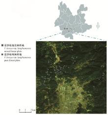
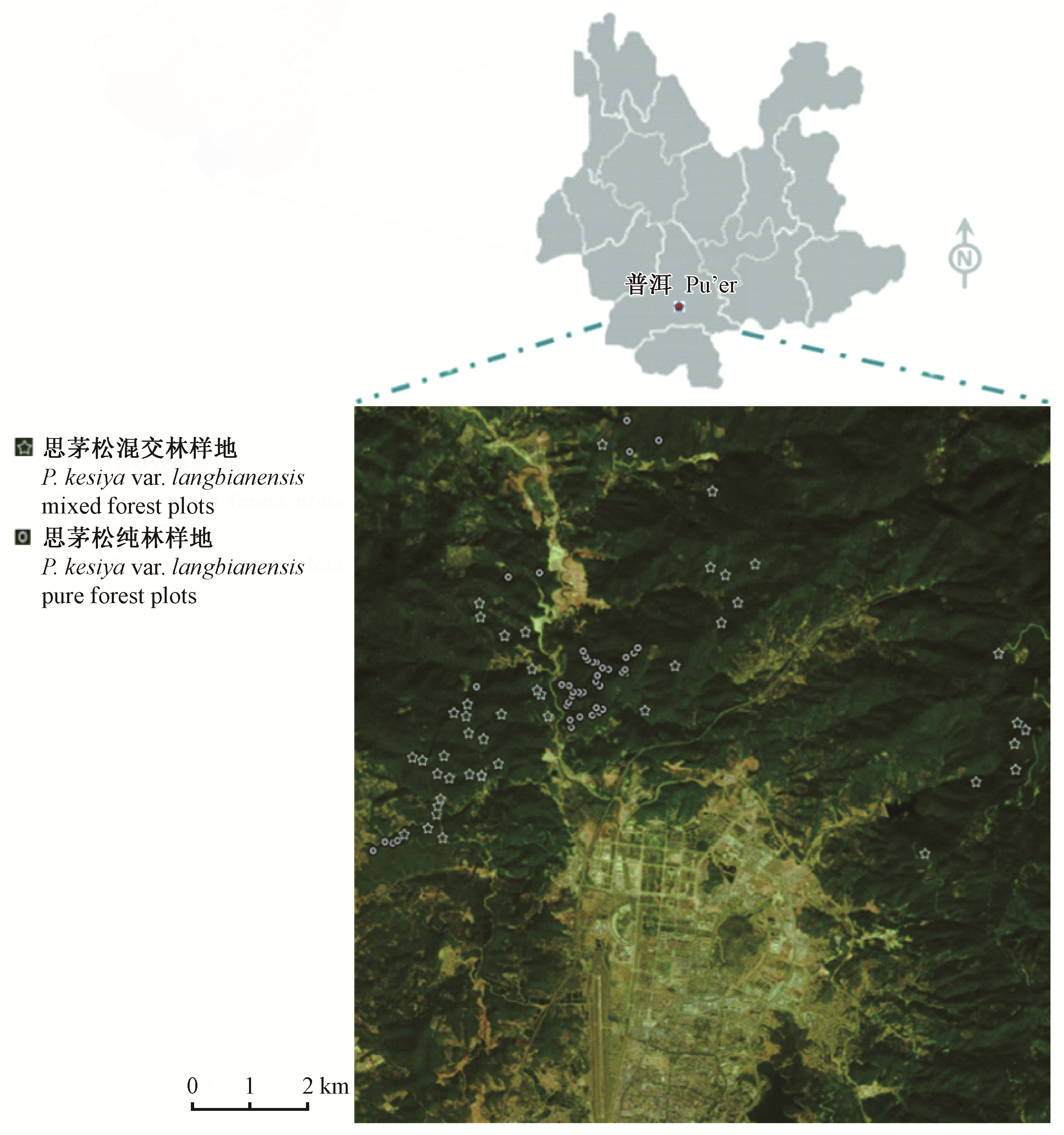
云南省林业调查规划院. 2016. 云南省思茅区森林资源规划设计调查报告. 昆明: 资源调查报告.
|
|
Yunnan forestry survey and Planning Institute. 2016. Investigation report on forest resources planning and design in Simao District, Yunnan Province. Kunming: Resource survey report. [in Chinese])
|
|
章皖秋. 2018. 基于TanDEM-X SAR数据的森林冠层高度估测. 昆明: 西南林业大学.
|
|
Zhang W Q. 2018. Estimation of forest canopy height based on TanDEM-X polarimetric and interferometric SAR data. Kunming: Southwest Forestry University. [in Chinese]
|
|
Bamler R , Hartl P . Synthetic aperture radar interferometry. Inverse Problems, 1998, 14 (4): R1.
doi: 10.1088/0266-5611/14/4/001
|
|
Caicoya A T , Kugler F , Hajnsek I , et al. Boreal forest biomass classification with TanDEM-X. International Geoscience and Remote Sensing Symposium (IGARSS), 2012, 3439- 3442.
|
|
Chen J H , Zhang H , Wang C , et al. Forest model for height estimation using PolInSAR data. Progress in Electromagetics Research Symposium Proceedings, Suzhou China, 2011, 1931- 1934.
|
|
Cloude S R. 2003. PolInSAR regularization using dual frequency interferometry. Proceedings of the International Conference on Radar(IEEE Cat. No. 03EX695), Adelaide, SA, Australia, 92-97.
|
|
Cloude S R . Polarsisation: applications in remote sensing. Beijing: Electronic Industry Press, 2015.
|
|
Cloude S R , Papathanssiou K P . PolariInetric SAR interferometry. IEEE Transations on Geoscience and Remote Sensing, 1998, 36 (5): 1551- 1565.
doi: 10.1109/36.718859
|
|
Denbina M, Simard M. 2016. The effects of temporal decorrelation and topographic slope on forest height retrieval using airborne repeat-pass L-band polarmetric SAR interferometry. Proceedings of 2016 IEEE International Geoscience and Remote Sensing Symposium(IGARSS 2016), Beijing, China, 1745-1748.
|
|
Flynn T , Tabb M , Carande R . Direct estimation of vegetation parameters from covariance data in polarimetric SAR interferometry. International Geoscience and Remote Sensing Symposium (IGARSS), 2002, 3, 1908- 1910.
|
|
Garestier F , Dubois-Fernandez P C , Champion I . Forest height inversion using high resolution P-band PolInSAR data. IEEE Transaction on Geoscience and Remote Sensing, 2008, 46 (11): 3544- 3559.
doi: 10.1109/TGRS.2008.922032
|
|
Garestier F , le Toan T . Vegetation modelling for height inversion using InSAR/Pol-InSAR data. International Geoscience and Remote Sensing Symposium (IGARSS), 2007, 2322- 2325.
|
|
Hajnsek I , Kugler F , Seungkuk L , et al. Tropical-forest-parameter estimation by means of PolInSAR: the INDREX-II campaign. IEEE Transactions on Geoscience & Remote Sensing, 2009, 47 (2): 481- 493.
|
|
Khati U, Singh G. 2015. Bistatic PolInSAR for forest height estimation: results from TanDEM-X. 2015 IEEE 5th Asia-Pacific Conference on Synthetic Aperture Radar, Singapore, 213-216.
|
|
Krieger G , Moreira A , Fiedler H , et al. TanDEM-X: a satellite formation for high-resolution SAR interferometry. IEEE Transactions on Geoscience and Remote Sensing, 2007, 45 (11): 3317- 3340.
doi: 10.1109/TGRS.2007.900693
|
|
Kugler F , Lee S , Hajnsek I . Forest height estimation by means of PolInSAR data inversion: the role of the vertical wavenumber. IEEE Transactions on Geoscience and Remote Sensing, 2015, 53 (10): 1- 18.
doi: 10.1109/TGRS.2015.2478083
|
|
Kumar S , Garg R D , Kushwaha S P S , et al. Bistatic PolInSAR inversion modelling for plant height retrieval in a tropical forest. Proceedings of the National Academy of Sciences, India Section A: Physical Sciences, 2017, 87 (4): 817- 826.
doi: 10.1007/s40010-017-0451-9
|
|
Lu H , Suo Z , Guo R , et al. S-RVoG model for forest parameters inversion over underlying topography. Electronics Letters, 2013, 49 (9): 618- 619.
doi: 10.1049/el.2012.4467
|
|
Minh N P . Slope three-layer scattering model for forest height estimation over mountain forest areas from L-band single-baseline PolInSAR data. Journal of Applied Remote Sensing, 2020, 12 (2): 1.
|
|
Minh N P , Wang C , Zou B , et al. Forest height extraction from PolInSAR image using a hybrid method. International Journal of Signal Processing Image Processing and Pattern Recognition, 2014, 7 (2): 257- 274.
doi: 10.14257/ijsip.2014.7.2.24
|
|
Papathanassiou K P , Cloude S R . Single-baseline polarimetric SAR interferometry. IEEE Transactions on Geoscience and Remote Sensing, 2001, 39 (11): 2352- 2362.
doi: 10.1109/36.964971
|
|
Parks J, Demirpolat C, Antropov O, et al. 2013. On forest height retrieval from spaceborne X-band interferometric SAR images under variable seasonal conditions. XXXIII Finnish URSI Convention on Radio Science and SMARAD Seminar 2013, 115-118.
|
|
Sadeghi Y , St-Onge B , Leblon B , et al. Canopy height model (CHM) derived from a TanDEM-X InSAR DSM and an airborne LiDAR DTM in boreal forest. IEEE Journal of Selected Topics in Applied Earth Observations and Remote Sensing, 2016, 9 (1): 381- 397.
doi: 10.1109/JSTARS.2015.2512230
|
|
Sexton J O , Bax T , Siqueira P , et al. A comparison of lidar, radar, and field measurements of canopy height in pine and hardwood forests of southeastern North America. Forest Ecology and Management, 2009, 257 (3): 1136- 1147.
doi: 10.1016/j.foreco.2008.11.022
|
|
Treuhaft R N , Cloude S R . The structure of oriented vegetation from polarimetric interferometry. IEEE Transaction on Geoscience and Remote Sensing, 1999, 37 (5): 2620- 2624.
doi: 10.1109/36.789657
|
|
Treuhaft R N , Madsen S N , Moghaddam M , et al. Vegetation characteristics and underlying topography from interferometric radar. Radio Science, 1996, 31 (6): 1449- 1485.
doi: 10.1029/96RS01763
|
|
Treuhaft R N , Siqueira P R . Vertical structure of vegetated land surfaces from interferometric and polarimetric radar. Radio Science, 2000, 35 (1): 141- 177.
doi: 10.1029/1999RS900108
|