
Scientia Silvae Sinicae ›› 2026, Vol. 62 ›› Issue (9): 96-109.doi: 10.11707/j.1001-7488.LYKX20250278
• Research papers • Previous Articles Next Articles
Ziqi Zhao1,2,Lingting Lei3,Guoqi Chai3,Xiaoli Zhang1,2,*( )
Received:2025-05-05
Online:2026-09-10
Published:2026-09-23
Contact:
Xiaoli Zhang
E-mail:zhang-xl@263.net
CLC Number:
Ziqi Zhao,Lingting Lei,Guoqi Chai,Xiaoli Zhang. A 3DGS 3D Modeling Framework for Forest Scenes Based on the Combination of LiDAR Data and UAV Image Point Clouds[J]. Scientia Silvae Sinicae, 2026, 62(9): 96-109.

Fig.1
Study area and locations of survey plots"
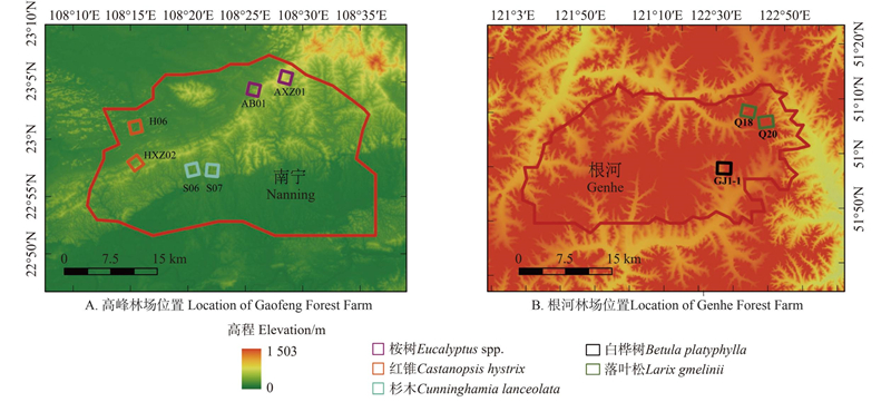
Table 1
Basic characteristics of the three plots"
| 样地编号 Plot number | 优势树种 Dominant tree species | 坡度 Slope/ (°) | 数量 Count | 冠幅 Crown width/m | 树高 Tree height/m |
| AB01 | 桉树 Eucalyptus spp. | 42 | 53 | 4.40±1.00 | 15.08±2.36 |
| AXZ01 | 桉树 Eucalyptus spp. | 47 | 15 | 2.70±1.20 | 27.20±3.40 |
| H06 | 红锥 Castanopsis hystrix | 31 | 68 | 4.82±1.76 | 18.10±5.64 |
| HXZ02 | 红锥 Castanopsis hystrix | 34 | 48 | 4.46±1.11 | 17.63±4.39 |
| S06 | 杉木 Cunninghamia lanceolata | 30 | 16 | 4.10±1.03 | 19.21±4.53 |
| S07 | 杉木 Cunninghamia lanceolata | 27 | 30 | 4.50±1.02 | 18.73±3.11 |
| GJ1-1 | 白桦树 Betula platyphylla | 36 | 62 | 3.84±1.55 | 17.07±3.02 |
| Q18 | 落叶松 Larix gmelinii | 14 | 45 | 5.51±1.72 | 15.23±3.46 |
| Q20 | 落叶松 Larix gmelinii | 9 | 54 | 4.26±1.00 | 14.92±5.21 |
Fig.2
Self-constructed dataset Forest"
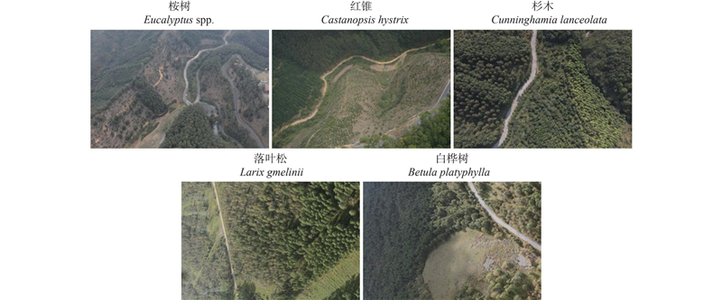
Table 2
Point cloud parameters of plots"
| 样地编号 Plot number | 优势树种 Dominant tree species | 平均点密度 Average point density/(pts·m–2) | 平均强度 Average intensity |
| AB01 | 桉树Eucalyptus spp. | 94 357.214 | 11 706.795 |
| AXZ01 | 桉树Eucalyptus spp. | 92 014.623 | 10 |
| H06 | 红锥Castanopsis hystrix | 9 842.486 | 11 782.395 |
| HXZ02 | 红锥Castanopsis hystrix | 88 347.036 | 13 526.341 |
| S06 | 杉木Cunninghamia lanceolata | 68 698.334 | 13 307.698 |
| S07 | 杉木Cunninghamia lanceolata | 69 423.779 | 14 271.322 |
| GJ1-1 | 白桦树Betula platyphylla | 12 020.731 | 58.823 |
| Q18 | 落叶松Larix gmelinii | 45 296.338 | 66.352 |
| Q20 | 落叶松Larix gmelinii | 9 602.912 | 67.533 |
Table 3
Handheld LiDAR scanning parameters in Gaofeng Forest Farm"
| 样地 编号 Plot number | 优势树种 Dominant tree species | 平均点密度 Average point density/ (pts·m–2) | 平均强度 Average intensity | 强度标 准差 Intensity standard deviation |
| AB01 | 桉树Eucalyptus spp. | 113 262.778 | 12 126.505 | 5 594.697 |
| AXZ01 | 桉树Eucalyptus spp. | 123 006.728 | 13 231.213 | 5 123.132 |
| H06 | 红锥Castanopsis hystrix | 172 85.203 | 11 232.123 | 2 394.632 |
| HXZ02 | 红锥Castanopsis hystrix | 118 352.624 | 13 001.441 | 4 671.397 |
| S06 | 杉木 Cunninghamia lanceolata | 72 698.335 | 12 307.221 | 2 345.343 |
| S07 | 杉木 Cunninghamia lanceolata | 71 158.774 | 14 507.308 | 5 499.795 |
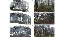
Fig.3
Handheld LiDAR point cloud data"
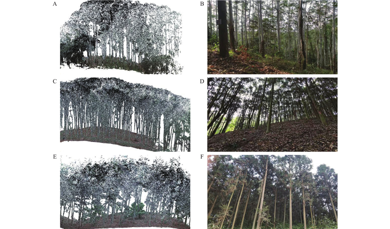
Table 4
Scanning parameters of ground-based LiDAR in Genhe Forest Farm plots"
| 样地编号 Plot number | 优势树种 Dominant tree species | 平均点密度 Average point density/ (pts·m–2) | 平均强度 Average intensity | 强度标准差 Intensity standard deviation |
| GJ1-1 | 白桦树 Betula platyphylla | 12 300.896 | 58.243 | 49.667 |
| Q18 | 落叶松 Larix gmelinii | 46 409.771 | 63.692 | 53.828 |
| Q20 | 落叶松 Larix gmelinii | 10 714.084 | 77.571 | 54.118 |

Fig.4
Ground-based LiDAR point cloud data"
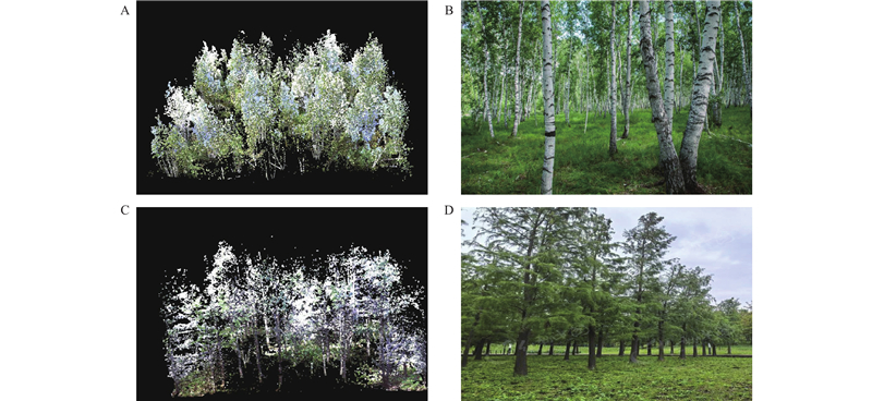

Fig.5
3DGS 3D modelling framework based on combining LiDAR data and UAV image point cloud"

Fig.6
Multi-scale ICP point cloud registration process"
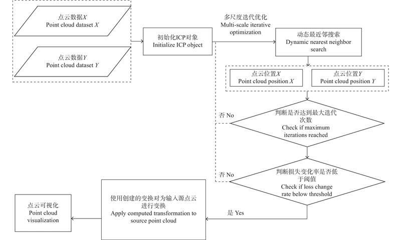

Fig.7
Architecture of the deformation multilayer perceptron (MLP)"
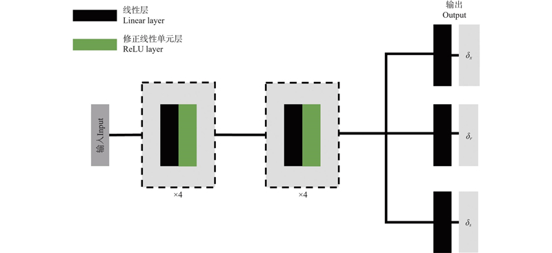
Table 5
Comparison of ablation experiment results on Forest dataset"
| 方法Methods | Time/min | CD/cm | Cov (%) | |
| A. w/o 3DGS | 171.2 | 10.5 | 4.32 | 91.2 |
| B. w/o MLP | 119.52 | 9.8 | 4.55 | 92.5 |
| C. w/o 3DGS & MLP | 22.47 | 11.2 | 3.76 | 90.2 |
| D. 本研究方法Ours | 19.26 | 8.2 | 4.87 | 95.1 |

Fig.8
Visual comparison of ablation experiments on Forest dataset"
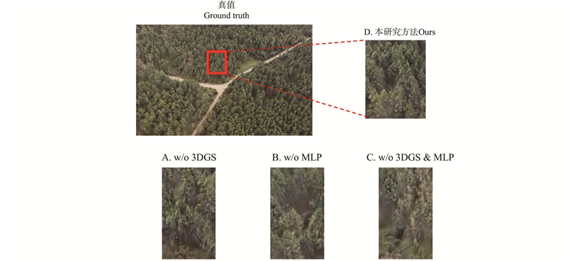
Table 6
Forest dataset comparison experiment results"
| 方法Methods | Time/min | CD/cm | Cov(%) | |
| NeRF | 170.6 | 32.5 | 8.83 | 86.7 |
| MVSNeRF | 119.3 | 30.8 | 9.14 | 88.4 |
| 3DGS | 32.51 | 28.7 | 9.47 | 91.5 |
| GaussianPro | 14.88 | 31.2 | 9.32 | 89.2 |
| 本研究方法Ours | 12.7 | 26.3 | 9.77 | 93.0 |

Fig.9
Visual comparison of comparison experiments on Forest dataset in Gaofeng Forest Farm"
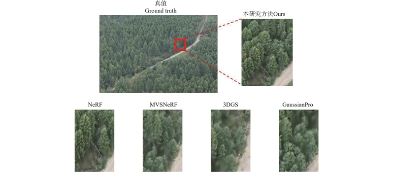

Fig.10
Visual comparison of comparison experiments on Forest dataset in Genhe Forest Farm"
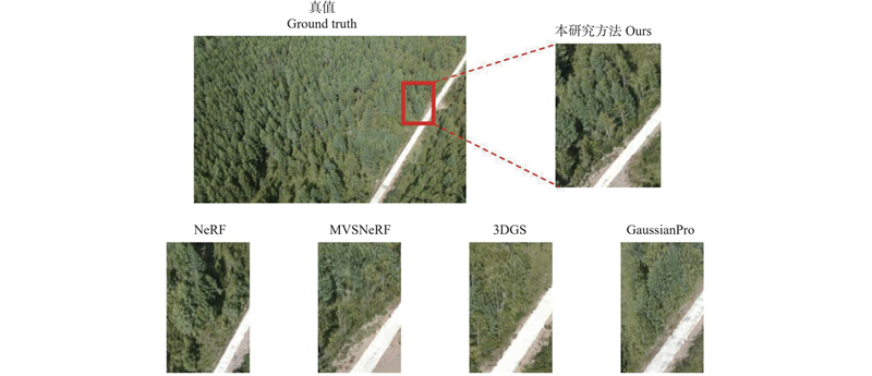

Fig.11
Accuracy verification of crown area extraction."


Fig.12
Accuracy verification of height extraction"

|
耿 林, 李明泽, 范文义, 等. 基于机载LiDAR的单木结构参数及林分有效冠的提取. 林业科学, 2018, 54 (7): 62- 72.
doi: 10.11707/j.1001-7488.20180707 |
|
|
Geng L, Li M Z, Fan W Y, et al. Individual tree structure parameters and effective crown of the stand extraction base on airborne LiDAR data. Scientia Silvae Sinicae, 2018, 54 (7): 62- 72.
doi: 10.11707/j.1001-7488.20180707 |
|
|
李永宁, 刘利民, 崔立艳, 等. 林冠开阔度对GNSS RTK在森林中定位可用性及初始化时间的影响. 林业科学, 2014, 50 (2): 78- 84.
doi: 10.11707/j.1001-7488.20140212 |
|
|
Li Y N, Liu L M, Cui L Y, et al. Effects of canopy openness on positioning availability and initialization time of GNSS RTK in forests. Scientia Silvae Sinicae, 2014, 50 (2): 78- 84.
doi: 10.11707/j.1001-7488.20140212 |
|
|
朱俊峰, 刘清旺, 崔希民, 等. 地基与无人机LiDAR融合点云的人工林蓄积量估算. 遥感技术与应用, 2024, 39 (1): 45- 54.
doi: 10.11873/j.issn.1004-0323.2024.1.0045 |
|
|
Zhu J F, Liu Q W, Cui X M, et al. Estimation of volume based on fusion point cloud of terrestrial and UAV LiDAR. Remote Sensing Technology and Application, 2024, 39 (1): 45- 54.
doi: 10.11873/j.issn.1004-0323.2024.1.0045 |
|
| Ardizzone F, Cardinali M, Galli M, et al. 2007. Identification and mapping of recent rainfall-induced landslides using elevation data collected by airborne Lidar. Natural Hazards and Earth System Sciences, 7(6): 637‒650. | |
|
Bagdasarian M T, Knoll P, Li Y H, et al. 3DGS.zip: a survey on 3D gaussian splatting compression methods. Computer Graphics Forum, 2025, 44, e70078.
doi: 10.1111/cgf.70078 |
|
| Chang D, Božič A, Zhang T, et al. 2022. RC-MVSNet: unsupervised multi-view stereo with neural rendering. Computer Vision–ECCV 2022. Cham: Springer Nature Switzerland, 665‒680. | |
| Chang J R, Chen Y S. 2018. Pyramid stereo matching network. 2018 IEEE/CVF Conference on Computer Vision and Pattern Recognition. Salt Lake City, UT, USA. IEEE, 5410‒5418. | |
| Chen A P, Xu Z X, Zhao F Q, et al. 2021. MVSNeRF: fast generalizable radiance field reconstruction from multi-view stereo. 2021 IEEE/CVF International Conference on Computer Vision (ICCV). Montreal, QC, Canada. IEEE, 14104‒14113. | |
| Cheng K, Long X X, Yang K Z, et al. 2024. GaussianPro: 3D Gaussian splatting with progressive propagation. arXiv: 2402.14650. | |
|
Chirico G B, Bonavolontà F. Metrology for agriculture and forestry 2019. Sensors, 2020, 20 (12): 3498.
doi: 10.3390/s20123498 |
|
| Ding Y K, Yuan W T, Zhu Q T, et al. 2022. TransMVSNet: global context-aware multi-view stereo network with transformers. 2022 IEEE/CVF Conference on Computer Vision and Pattern Recognition (CVPR). New Orleans, LA, USA. IEEE, 8575‒8584. | |
| Gong Y H, Yu L T, Yue G H. 2024. Isotropic Gaussian splatting for real-time radiance field rendering. arXiv: 2403.14244. | |
|
Guan H, Smith W A. P. Structure-from-motion in spherical video using the von mises-fisher distribution. IEEE Transactions on Image Processing, 2017, 26 (2): 711- 723.
doi: 10.1109/TIP.2016.2621662 |
|
|
Guo J W, Xu S B, Yan D M, et al. Realistic procedural plant modeling from multiple view images. IEEE Transactions on Visualization and Computer Graphics, 2020, 26 (2): 1372- 1384.
doi: 10.1109/TVCG.2018.2869784 |
|
| Held J, Vandeghen R, Hamdi A, et al. 2025.3D convex splatting: radiance field rendering with 3D smooth convexes. 2025 IEEE/CVF Conference on Computer Vision and Pattern Recognition (CVPR). Nashville, TN, USA. IEEE, 21360‒21369. | |
| Huang Y H, Sun Y T, Yang Z Y, et al. 2024. SC-GS: sparse-controlled Gaussian splatting for editable dynamic scenes. 2024 IEEE/CVF Conference on Computer Vision and Pattern Recognition (CVPR). Seattle, WA, USA. IEEE, 4220‒4230. | |
| Huang Z X, Xu M, Perry S. 2025. StructGS: adaptive spherical harmonics and rendering enhancements for superior 3D Gaussian splatting. arXiv: 2503.06462. | |
|
Li X X, Huang J X, Li X, et al. Review of PPP-RTK: achievements, challenges, and opportunities. Satellite Navigation, 2022, 3 (1): 28.
doi: 10.1186/s43020-022-00089-9 |
|
| Mildenhall B, Srinivasan P P, Tancik M, et al. 2020. NeRF: representing scenes as neural radiance fields for view synthesis. Computer Vision – ECCV 2020. Cham: Springer International Publishing, 405‒421. | |
| Rublee E, Rabaud V, Konolige K, et al. 2011. ORB: an efficient alternative to SIFT or SURF. 2011 International Conference on Computer Vision. Barcelona, Spain. IEEE, 2564‒2571. | |
|
Shao J, Yao W, Wan P, et al. Efficient co-registration of UAV and ground LiDAR forest point clouds based on canopy shapes. International Journal of Applied Earth Observation and Geoinformation, 2022, 114, 103067.
doi: 10.1016/j.jag.2022.103067 |
|
|
Szalai-Gindl J M, Varga D. FPFH revisited: histogram resolutions, improved features, and novel representation. IEEE Access, 2024, 12, 67325- 67354.
doi: 10.1109/ACCESS.2024.3400591 |
|
| Wang Y B, Jiang L, Yang M H, et al. 2019. Eidetic 3D LSTM: A Model for Video Prediction and Beyond. 2019 International Conference on Learning Representations (ICLR). New Orleans, LA, USA. | |
| Wu M Y, Dai H Z, Yao K X, et al. 2025. BG-triangle: Bézier Gaussian triangle for 3D vectorization and rendering. 2025 IEEE/CVF Conference on Computer Vision and Pattern Recognition (CVPR). Nashville, TN, USA. IEEE, 16197‒16207. | |
|
Xu C L, Wu C D, Qu D K, et al. Accurate and efficient stereo matching by log-angle and pyramid-tree. IEEE Transactions on Circuits and Systems for Video Technology, 2021, 31 (10): 4007- 4019.
doi: 10.1109/TCSVT.2020.3044891 |
|
| Yang Y, Xu H R, Weng L F. 2022. A multi-view matching method based on PatchmatchNet with sparse point information. Proceedings of the 4th World Symposium on Software Engineering. Xiamen China. ACM, 9‒14. | |
| Yao Y, Luo Z X, Li S W, et al. 2018. MVSNet: depth inference for unstructured multi-view stereo. Computer Vision – ECCV 2018. Cham: Springer International Publishing, 785‒801. | |
|
You H T, Liu Y, Lei P, et al. Segmentation of individual mangrove trees using UAV-based LiDAR data. Ecological Informatics, 2023, 77, 102200.
doi: 10.1016/j.ecoinf.2023.102200 |
|
|
Yu T Y, Ni W J, Liu J L, et al. Extraction of tree heights in mountainous natural forests from UAV leaf-on stereoscopic imagery based on approximation of ground surfaces. Remote Sensing of Environment, 2023, 293, 113613.
doi: 10.1016/j.rse.2023.113613 |
|
|
Yun T, Jiang K, Li G C, et al. Individual tree crown segmentation from airborne LiDAR data using a novel Gaussian filter and energy function minimization-based approach. Remote Sensing of Environment, 2021, 256, 112307.
doi: 10.1016/j.rse.2021.112307 |
|
| Zhang K, Riegler G, Snavely N, et al. 2020. NeRF++: analyzing and improving neural radiance fields. arXiv: 2010.07492. |
| [1] | Xin Liu,Yuanshuo Hao,Lihu Dong,Yinghui Zhao,Fengri Li. Development of a Basal Area Growth Estimation Model for Individual Trees of Larix olgensis Plantations based on UAV-LiDAR Data [J]. Scientia Silvae Sinicae, 2026, 62(8): 11-20. |
| [2] | Ying Quan,Guofan Shao,Mingze Li. From Empirical Models to Intelligent Estimation: An Innovation Pathway of Remote Sensing Technology in Monitoring Forest Carbon Stocks in Northeast China [J]. Scientia Silvae Sinicae, 2026, 62(6): 236-248. |
| [3] | Yunhe Li,Sirong Wang,Yisa Li,Dengsheng Lu. Comparative Analysis of Individual Tree Parameter Extraction Accuracy Using Integrated Data Collected by Airborne and Handheld LiDAR in Subtropical Typical Forests [J]. Scientia Silvae Sinicae, 2026, 62(6): 82-95. |
| [4] | Shimei Xiong,Bingxiang Tan,Wenqiang Xu,Xiaoyao Li,Lifeng Pang,Bing Hu. Estimation of Aboveground Biomass in Desert Haloxylon ammodendron Shrubland Based on UAV Multispectral and LiDAR Data [J]. Scientia Silvae Sinicae, 2026, 62(6): 96-108. |
| [5] | Yining Lian,Hao Lu,Yongjian Huai,Haifeng Xu,Langning Huo,Zhichao Wang. Point Cloud Semantic-Guided Individual Tree Segmentation and Parameter Estimation Using UAV Laser Scanning [J]. Scientia Silvae Sinicae, 2026, 62(4): 106-117. |
| [6] | Weisheng Zeng,Xuexiang Wen,Han Fu,Xiangnan Sun,Kangmei Lü,Qiangyi Liu,Tian Wang. Establishment and Application of Simultaneous Models for Estimating Major Stand Characteristics in Beijing Based on LiDAR Data [J]. Scientia Silvae Sinicae, 2026, 62(4): 68-80. |
| [7] | Sheng Zhou,Fugen Jiang,Shuai Chen,Yi Long,Binbin Wang,Zige Song,Hua Sun. Estimation of Forest Aboveground Biomass Using Joint Spaceborne-UAV LiDAR and Sentinel-2 Data [J]. Scientia Silvae Sinicae, 2026, 62(3): 74-87. |
| [8] | Yujiao Zhang,Hengqian Zhao,Hancong Fu,Ge Liu,Xiadan Huangfu,Xuanqi Liu. Inversion Model of Aboveground Biomass at Individual Tree Scale Based on the Multiple Features of UAV Remote Sensing [J]. Scientia Silvae Sinicae, 2025, 61(8): 129-141. |
| [9] | Xiaoyan Xiong,Caixia Li,Guoqi Chai,Long Chen,Xiang Jia,Lingting Lei,Xiaoli Zhang. Estimation of Aboveground Biomass in Regional Forests by Using Integrating UAV-LiDAR and GEDI Data [J]. Scientia Silvae Sinicae, 2025, 61(8): 142-153. |
| [10] | Jiamin Wu,Yaxin Wang,Bin Sun,Zhijie Ma,Weina Sun,Liang Hong. Remote Sensing Estimation of Biomass of Caragana korshinskii with UAV [J]. Scientia Silvae Sinicae, 2025, 61(6): 13-24. |
| [11] | Luxia Liu,Bo Hu,Guoqing Sang,Yuyu Liu. Assessing Forest Vegetation Diversity Using Forest Structure Indicators Based on LiDAR Remote Sensing: A Review [J]. Scientia Silvae Sinicae, 2025, 61(1): 176-196. |
| [12] | Zhongyang Hu,Liang Shan,Xiangyu Chen,Kunyong Yu,Jian Liu. Individual Tree Segmentation of UAV-LiDAR Based on the Combination of CHM and DSM [J]. Scientia Silvae Sinicae, 2024, 60(8): 14-24. |
| [13] | Dan Kong,Yong Pang,Xiaojun Liang,Liming Du,Yu Bai. Individual Tree Segmentation from ALS Point Clouds Based on Layers Stacking Algorithm [J]. Scientia Silvae Sinicae, 2024, 60(3): 87-99. |
| [14] | Zhou Xiangbei, Li Chungan, Dai Huabing, Yu Zhu, Li Zhen, Su Kai. Effects of Point Cloud Density on the Estimation Accuracy of Large-Area Subtropical Forest Inventory Attributes Using Airborne LiDAR Data [J]. Scientia Silvae Sinicae, 2023, 59(9): 23-33. |
| [15] | Xiaohui Yang,Jinzhuo Wu,Haoran Liu,Hao Zhong,Wenshu Lin. Estimation on Canopy Closure for Plantation Forests Based on UAV-LiDAR [J]. Scientia Silvae Sinicae, 2023, 59(8): 12-21. |
| Viewed | ||||||
|
Full text |
|
|||||
|
Abstract |
|
|||||
