
Scientia Silvae Sinicae ›› 2023, Vol. 59 ›› Issue (4): 18-31.doi: 10.11707/j.1001-7488.LYKX20220621
• High-quality development of forestry in the Yellow River Basin • Previous Articles Next Articles
Pingping Li1,2,Yanhui Wang2( ),Wenbiao Duan1,*,Yirui Wang1,2,Pengtao Yu2,Li Zhen1,2,Zhixin Li3,Huijun Shang3,Zaijun Shi3,Yipeng Yu2
Received:2022-09-08
Online:2023-04-25
Published:2023-07-05
Contact:
Wenbiao Duan
E-mail:wangyh@caf.ac.cn
CLC Number:
Pingping Li,Yanhui Wang,Wenbiao Duan,Yirui Wang,Pengtao Yu,Li Zhen,Zhixin Li,Huijun Shang,Zaijun Shi,Yipeng Yu. Variation and Evaluation of Site Index of Black Locust Plantations on the Loess Plateau of Northwest China[J]. Scientia Silvae Sinicae, 2023, 59(4): 18-31.
Table 1
Basic information of study sites from literature and the inventory of authors"
| 调查地点 Study sites | 林龄 Forest age/ a | 密度 Stand density / (trees·hm?2) | MAP/mm | MAT/ ℃ | 海拔 Altitude/ m | SA/(°) | 坡度 Slope gradient/(°) | 样地数 Plot quantity | 参考文献 References |
| 甘肃省 Gansu Province | |||||||||
| 泾川县官山林场 Guanshan Forest Farm of Jingchuan County | 7~45 | 1 100~3 240 | 475~555 | 9.2~10.5 | 1 035~1 314 | 21~157.5 | 0~38 | 37 | 笔者调查 Author's survey |
| 27 | |||||||||
| 庄浪、天水、通渭、环县 Counties of Zhuanglang, Tianshui, Tongwei, Huan xian | 8~28 | 3 330~6 990 | 408~548 | 7.5~11 | — | 22.5~67.5 | — | 4 | |
| 陕西省 Shaanxi Province | |||||||||
| 安塞县纸坊沟流域 Zhifanggou watershed, Ansai County, | 9~40 | 900~2 475 | 500~543 | 8.8 | 1 006~1 296 | 45~169.5 | 16~43 | 14 | |
| 安塞县南沟流域 Nangou watershed, Ansai County | 2~9 | 675~2 800 | 505 | 8.8 | 1 050~1 440 | 22.5~157.5 | — | 9 | |
| 延安羊圈沟小流域 Yangguangou small watershed in Yan'an | 12~28 | 1 200~2 500 | 531.0 | 9.8 | 1 169~1 172 | 90 | 24~26 | 2 | |
| 黄陵、陇县、富县、延长、清涧、米脂、神木、永寿县 Counties of Huangling, Long xian, Fu xian, Yanchang, Qingjian, Mizhi, Shenmu, Yongshou | 11~25 | 1 222~3 334 | 441~630 | 8.5~10.8 | — | 22.5~157.5 | — | 11 | |
| 山西省 Shanxi Province | |||||||||
| 吉县蔡家川流域 Caijiachuan watershed, Jixian County | 18~36 | 667~1 625 | 576 | 10 | 1 091~1 226 | 70~160 | 18~33 | 8 | |
| 吉县红旗林场 Hongqi forest farm, Jixian County | 14 | — | 576 | 10 | 1 100~1 270 | 22.5~157.5 | — | 11 | |
| 方山县和吉县 Fangshan County and Jixian County | 11~25 | 833~2 222 | 497~576 | 7.3~10.6 | 800~1 350 | 22.5~157.5 | — | 46 | |
| 偏关县以南的西部沿黄一带 Western area along Yellow River, south of Pianguan County | 2~18 | — | 500 | 8 | — | 22.5~157.5 | — | 45 | |
| 古县、兴县、离石县 Counties of Guxian, Xingxian , and Lishi | 7~20 | 1 894~4 813 | 491~576 | 8.9~11.8 | — | 22.5 | — | 3 | |
| 宁夏回族自治区 Ningxia Hui Autonomous Region | |||||||||
| 固原、西吉 Counties of Guyuan and Xiji | 11~23 | 1 660~1 665 | 435~478 | 6~6.2 | — | 22.5 | — | 2 | |
Table 2
Regression coefficients and standardized values of topography positions for the equation of average height of dominant trees in black locust plantations"
| 地形部位 Topography positions | 回归系数 The regression coefficients of bi | 回归系数值 The values of regression coefficients | 标准化的回归系数值 Standardized values of regression coefficients |
| 常数项 Constant term | | 4.910 | |
| 沟底 Valley bottom | | 0.993 | 1.000 |
| 塬面 Tableland | | 0.827 | 0.906 |
| 梁坡下部 Lower part of ridge slope | | 0.706 | 0.837 |
| 梁坡中部 Middle part of ridge slope | | 0.001 | 0.438 |
| 梁坡上部 Upper part of ridge slope | | ?0.462 | 0.176 |
| 沟坡 Gully slope | | ?0.401 | 0.210 |
| 梁峁顶 Ridge top | | ?0.772 | 0.000 |

Fig.1
Variation of relative tree height of dominant trees with main factors and response function types"


Fig.2
Validation of the model of average height of dominant trees and residual analysis"
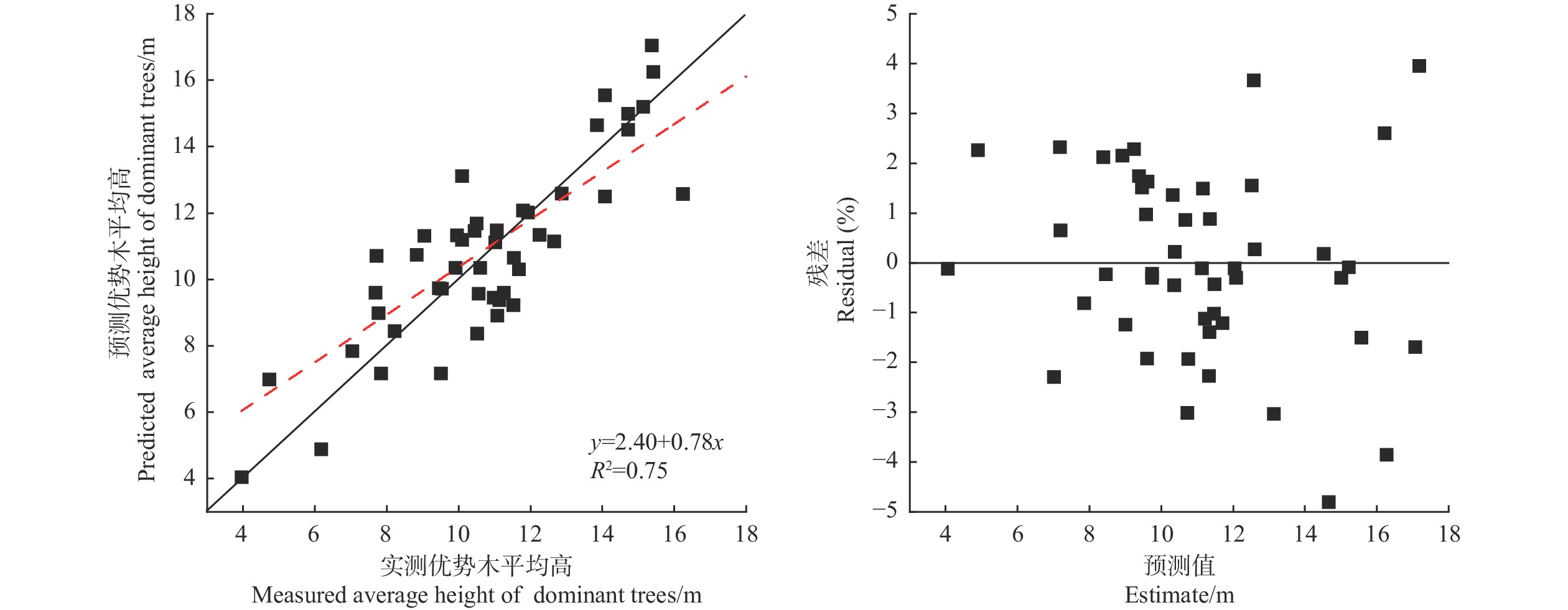
Fig.3
Variation of simulated site index with mean annual temperature and mean annual precipitation at the sites of hilly top, middle part of shady ridge slope, and gully bottom"

Table 3
Area proportion of the graded combination of mean annual temperature and mean annual precipitation on the Loess Plateau %"
| 年均气温/年均降水量 Mean annual temperature / Mean annual precipitation | <400 mm (过旱Too dry) | 400~450 mm (旱Dry) | 450~550 mm (润Moist) | 550~700 mm (湿Wet) | 合计 Total |
| <6 ℃(过冷Too cold) | 5.62 | 2.38 | 1.29 | 0.46 | 9.74 |
| 6~7.5 ℃(冷Cold) | 13.65 | 3.41 | 2.97 | 0.39 | 20.43 |
| 7.5~11.0 ℃(温Mild) | 19.02 | 6.45 | 19.81 | 7.49 | 52.77 |
| >11.0 ℃(暖Warm) | 0.21 | 0.00 | 3.42 | 13.44 | 17.06 |
| 合计Total | 38.49 | 12.24 | 27.48 | 21.78 | 100.00 |

Fig.4
Climatic subzones on the Loess Plateau according to the mean annual precipitation and mean annual air temperature for black locust plantations"

Table 4
Site index of site types in climate subzones where black locust can grow on the Loess Plateau"
| 立地类型 Site types | 冷旱/润区 Cold-dry/moist | 温旱区 Mild-dry | 温润区 Mild-moist | 温湿区 Mild-wet | 暖润区 Warm-moist | 暖湿区 Warm-wet | 平均值 Average | |||||
| 6.0~7.5 ℃, >400 mm | 7.5~11.0 ℃, 400~450 mm | 7.5~11.0 ℃, 450~550 mm | 7.5~11.0 ℃, 550~700 mm | >11.0 ℃, 450~550 m | >11.0 ℃, 550~700 mm | |||||||
| 沟底 Gully bottom | 8.4 | 9.9 | 14.9 | 16.3 | 9.5 | 10.9 | 11.7 | |||||
| 塬面 Tableland | 8.1 | 9.6 | 14.4 | 15.8 | 9.2 | 10.5 | 11.3 | |||||
| 阴面梁坡下部 Lower part of shady ridge slope | 7.9 | 9.4 | 14.1 | 15.4 | 9.0 | 10.3 | 11.0 | |||||
| 半阴面梁坡下部 Lower part of semi-shady ridge slope | 7.7 | 9.1 | 13.6 | 14.9 | 8.7 | 9.9 | 10.7 | |||||
| 半阳面梁坡下部 Lower part of semi-sunny ridge slope | 7.4 | 8.8 | 13.2 | 14.5 | 8.4 | 9.6 | 10.3 | |||||
| 阳面梁坡下部 Lower part of sunny ridge slope | 7.2 | 8.5 | 12.7 | 14.0 | 8.2 | 9.3 | 10.0 | |||||
| 阴面梁坡中部 Middle part of shady ridge slope | 6.8 | 8.0 | 12.0 | 13.2 | 7.7 | 8.8 | 9.4 | |||||
| 半阴面梁坡中部 Middle part of semi-shady ridge slope | 6.6 | 7.8 | 11.6 | 12.8 | 7.5 | 8.5 | 9.1 | |||||
| 半阳面梁坡中部 Middle part of semi-sunny ridge slope | 6.4 | 7.5 | 11.3 | 12.4 | 7.2 | 8.2 | 8.8 | |||||
| 阳面梁坡中部 Middle part of sunny ridge slope | 6.2 | 7.3 | 10.9 | 12.0 | 7.0 | 8.0 | 8.6 | |||||
| 阴面沟坡 Shady gully slope | 6.1 | 7.2 | 10.8 | 11.9 | 6.9 | 7.9 | 8.5 | |||||
| 阴面梁坡上部 Upper part of shady ridge slope | 6.0 | 7.1 | 10.7 | 11.7 | 6.8 | 7.8 | 8.4 | |||||
| 半阴面沟坡 Semi-shady gully slope | 5.9 | 7.0 | 10.5 | 11.5 | 6.7 | 7.7 | 8.2 | |||||
| 半阴面梁坡上部 Upper part of semi-shady ridge slope | 5.8 | 6.9 | 10.3 | 11.3 | 6.6 | 7.5 | 8.1 | |||||
| 半阳面沟坡 Semi-sunny gully slope | 5.7 | 6.8 | 10.2 | 11.2 | 6.5 | 7.4 | 8.0 | |||||
| 半阳面梁坡上部 Upper part of semi-sunny ridge slope | 5.7 | 6.7 | 10.0 | 11.0 | 6.4 | 7.3 | 7.9 | |||||
| 阳面沟坡 Sunny gully slope | 5.6 | 6.6 | 9.8 | 10.8 | 6.3 | 7.2 | 7.7 | |||||
| 阳面梁坡上部 Upper part of sunny ridge slope | 5.5 | 6.5 | 9.7 | 10.6 | 6.2 | 7.1 | 7.6 | |||||
| 梁峁顶 Hilly top | 4.9 | 5.9 | 8.9 | 9.7 | 5.7 | 6.5 | 6.9 | |||||
| 最大值 Max. | 8.4 | 9.9 | 14.9 | 16.3 | 9.5 | 10.9 | 11.7 | |||||
| 最小值 Min. | 4.9 | 5.9 | 8.9 | 9.7 | 5.7 | 6.5 | 6.9 | |||||
| 平均值 Average | 6.5 | 7.7 | 11.6 | 12.7 | 7.4 | 8.5 | 9.1 |
|
陈永富. 基准年龄立地质量评价的影响分析. 林业科学研究, 2010, 23 (2): 283- 287.
doi: 10.13275/j.cnki.lykxyj.2010.02.015 |
|
|
Chen Y F. Research on standard age affecting analysis of site quality evaluation. Forest Research, 2010, 23 (2): 283- 287.
doi: 10.13275/j.cnki.lykxyj.2010.02.015 |
|
| 段良霞. 2017. 黄土高塬沟壑区坡地水量转换的空间变异性. 杨凌: 西北农林科技大学. | |
| Duan L X. 2017. Spatial variability of water transformation in hillslope transects on the loess gully region. Yangling: Northwest A & F University. [in Chinese] | |
|
范 阔, 苏晓慧, 张艺超, 等. 运用改进Richards模型预测马尾松人工林立地指数——以广西高峰林场为例. 东北林业大学学报, 2019, 47 (9): 48- 51.
doi: 10.3969/j.issn.1000-5382.2019.09.009 |
|
|
Fan K, Su X H, Zhang Y C, et al. Prediction of Pinus massoniana plantation site index using improved Richards model – Take Guangxi Gaofeng Forest Farm as an example . Journal of Northeast Forestry University, 2019, 47 (9): 48- 51.
doi: 10.3969/j.issn.1000-5382.2019.09.009 |
|
|
耿 兵, 王华田, 王延平, 等. 刺槐萌生林与实生林的生长比较. 中国水土保持科学, 2013, 11 (2): 59- 64.
doi: 10.3969/j.issn.1672-3007.2013.02.010 |
|
|
Geng B, Wang H T, Wang Y P, et al. Comparative study of coppice and seeding forest of Robinia pseudoacacia L . Science of Soil and Water Conservation, 2013, 11 (2): 59- 64.
doi: 10.3969/j.issn.1672-3007.2013.02.010 |
|
|
韩宏伟, 张世红, 徐兴兴, 等. 中国刺槐种源间抗寒性地理变异研究. 河北农业大学学报, 2008, 31 (2): 57- 60.
doi: 10.3969/j.issn.1000-1573.2008.02.013 |
|
|
Han H W, Zhang S H, Xu X X, et al. Study on geographic variation of cold resistance among provenances of Robinia pseudoacacia in China . Journal of Hebei Agricultural University, 2008, 31 (2): 57- 60.
doi: 10.3969/j.issn.1000-1573.2008.02.013 |
|
|
韩蕊莲, 侯庆春. 延安试区刺槐林地在不同立地条件下土壤水分变化规律. 西北林学院学报, 2003, 18 (1): 74- 76.
doi: 10.3969/j.issn.1001-7461.2003.01.022 |
|
|
Han R L, Hou Q C. Soil water changing of artificial Robinia persudoscacia at different site conditions in Yan’an experimental area . Journal of Northwest Forestry University, 2003, 18 (1): 74- 76.
doi: 10.3969/j.issn.1001-7461.2003.01.022 |
|
|
洪玲霞. 初植密度、间伐对杉木林分优势高生长过程的影响. 林业科学研究, 1997, 10 (4): 448- 452.
doi: 10.3321/j.issn:1001-1498.1997.04.019 |
|
|
Hong L X. Effects of initial planting density and thinning on the growth process of dominant height of Chinese fir stand. Forest Research, 1997, 10 (4): 448- 452.
doi: 10.3321/j.issn:1001-1498.1997.04.019 |
|
| 侯淑艳. 2013. 北京市低山区低效人工林结构特征与评价研究. 北京: 北京林业大学. | |
| Hou S Y. 2013. Study on the assessment and structural feature of low function plantation in the low mountain of Beijing. Beijing: Beijing Forestry University. [in Chinese] | |
|
景贯阳, 邸 利, 王安民, 等. 甘肃泾川不同林龄人工刺槐林的土壤水分-物理特性及渗透性研究. 四川农业大学学报, 2017, 35 (2): 193- 198.
doi: 10.16036/j.issn.1000-2650.2017.02.009 |
|
|
Jing G Y, Di L, Wang A M, et al. Soil hydrological characteristics of different age artificial Robinia pseudoacacia forests in the Gully Area Loess Plateau of eastern Gansu . Journal of Sichuan Agricultural University, 2017, 35 (2): 193- 198.
doi: 10.16036/j.issn.1000-2650.2017.02.009 |
|
| 焦 醒, 刘广全. 黄土高原刺槐生长状况及其影响因子. 国际沙棘研究与开发, 2009, 6 (2): 42- 48. | |
| Jiao X, Liu G Q. Growth status and influencing factors of Robinia pseudoacacia on the Loess Plateau . International Seabuckthorn Research and Development, 2009, 6 (2): 42- 48. | |
|
孔凌霄, 毕华兴, 周巧稚, 等. 晋西黄土区不同立地刺槐林土壤水分动态特征. 水土保持学报, 2018, 32 (5): 163- 169.
doi: 10.13870/j.cnki.stbcxb.2018.05.027 |
|
|
Kong L X, Bi H X, Zhou Q Z, et al. Dynamic characteristics of soil moisture in Robinia pseudoacacia forests at different sites in the loess region of western Shanxi . Journal of Soil and Water Conservation, 2018, 32 (5): 163- 169.
doi: 10.13870/j.cnki.stbcxb.2018.05.027 |
|
|
李俊国, 苟素娟, 韩恩贤, 等. 渭北旱塬沟壑区不同立地条件刺槐林生长分析. 陕西林业科技, 2007, (4): 18- 20.
doi: 10.3969/j.issn.1001-2117.2007.04.005 |
|
|
Li J G, Gou S J, Han E X, et al. Growth analysis of Robinia pseudoacacia grown under different site conditions on arid gully area of Weibei Plateau . Shaanxi Forestry Science and Technology, 2007, (4): 18- 20.
doi: 10.3969/j.issn.1001-2117.2007.04.005 |
|
| 李凯荣, 王佑民. 黄土塬区刺槐林地水分条件与生产力研究. 水土保持通报, 1990, 10 (6): 58- 65. | |
| Li K R, Wang Y M. Study on water condition and productivity of Robinia pseudoacacia forest land in Loess Plateau . Bulletin of Soil and Water Conservation, 1990, 10 (6): 58- 65. | |
| 李业宇, 曹帮华, 倪智雄, 等. 徂徕山刺槐人工林立地分类及立地质量评价. 浙江林业科技, 2020, 40 (3): 38- 44. | |
| Li Y Y, Cao B H, Ni Z X, et al. Site classification and quality evaluation of Robinia pseudoacacia plantation in Culai Mountain . Journal of Zhejiang Forestry Science and Technology, 2020, 40 (3): 38- 44. | |
| 李忠喜, 朱延林, 王润军, 等. 原生种源刺槐抗寒性地理变异研究. 上海农业学报, 2015, 31 (1): 63- 66. | |
| Li Z X, Zhu Y L, Wang R J, et al. Geographic variation of coil resistance of Robinia pseudoacacia provenances . Acta Agriculturae Shanghai, 2015, 31 (1): 63- 66. | |
| 刘财富, 常新东, 梁玉堂, 等. 辽宁省刺槐人工林立地质量评价的研究. 吉林林学院学报, 1998, 14 (2): 14- 20. | |
| Liu C F, Chang X D, Liang Y T, et al. Study on site quality evaluation of Robinia pseudoacacia plantation in Liaoning Province . Journal of Jilin Forestry University, 1998, 14 (2): 14- 20. | |
|
刘国彬, 上官周平, 姚文艺, 等. 黄土高原生态工程的生态成效. 中国科学院院刊, 2017, 32 (1): 11- 19.
doi: 10.16418/j.issn.1000-3045.2017.01.002 |
|
|
Liu G B, Shangguan Z P, Yao W Y, et al. Ecological effects of soil conservation in Loess Plateau. Bulletin of Chinese Academy of Sciences, 2017, 32 (1): 11- 19.
doi: 10.16418/j.issn.1000-3045.2017.01.002 |
|
|
刘建利, 李凯荣, 易 亮, 等. 黄土高原丘陵区人工刺槐林林分结构及林下植物多样性研究. 水土保持通报, 2008, 28 (3): 49- 52,70.
doi: 10.13961/j.cnki.stbctb.2008.03.034 |
|
|
Liu J L, Li K R, Yi L, et al. Structure of Robinia pseudoacacia plantation and undergrowth plant diversity in the hilly area of the Loess Plateau . Bulletin of Soil and Water Conservation, 2008, 28 (3): 49- 52,70.
doi: 10.13961/j.cnki.stbctb.2008.03.034 |
|
| 刘江华. 2008. 黄土高原刺槐人工林生长特征及其天然化程度评价. 杨凌: 中国科学院研究生院(教育部水土保持与生态环境研究中心). | |
| Liu J H. 2008. Study on growth traits of Robinia pseudoacacia plantation and its naturalization process on Loess Plateau. Yangling: Graduate University of Chinese Academy of Sciences (Soil and Water Conservation and Ecological Environment Research Center of the Ministry of Education). [in Chinese] | |
| 柳 洋. 2021. 陇中黄土丘陵区不同林龄刺槐林根系特征及边坡稳定性研究. 兰州: 兰州大学. | |
| Liu Y. 2021. Research on the root system characteristics and slope stability of Robinia pseudoacacia L. forests with different stand ages in the loess hilly area of central Gansu. Lanzhou: Lanzhou University. [in Chinese] | |
| 刘 愿. 2019. 黄土丘陵区不同林龄刺槐人工林水分、养分特征. 杨凌: 西北农林科技大学. | |
| Liu Y. 2019. Water and nutrient characteristics of Robinia pseudoacacia plantations of different ages in the loess hilly region. Yangling: Northwest A & F University. [in Chinese] | |
|
刘 愿, 陈云明, 梁思琦, 等. 陕北黄土丘陵区刺槐人工林土壤生态化学计量特征. 水土保持研究, 2019, 26 (4): 43- 49.
doi: 10.13869/j.cnki.rswc.2019.04.007 |
|
|
Liu Y, Chen Y M, Liang S Q, et al. Soil ecological stoichiometry characteristics of Robinia pseudoacacia plantation in the loess hilly region of northern Shaanxi . Research of Soil and Water Conservation, 2019, 26 (4): 43- 49.
doi: 10.13869/j.cnki.rswc.2019.04.007 |
|
| 罗军伟. 2017. 鲁中山区不同立地条件下侧柏、赤松、刺槐生长分析与模拟. 泰安: 山东农业大学. | |
| Luo J W. 2017. Growth analysis and simulation of Platycladus orientalis, Pinus densiflora and Robinia pseudoacacia under different site conditions in the central Shandong mountain area. Taian: Shandong Agricultural University. [in Chinese] | |
|
马娟霞, 肖 玲, 关帅朋, 等. 黄土高原刺槐林地土壤水分与立地因子关系研究. 土壤通报, 2010, 41 (6): 1311- 1315.
doi: 10.19336/j.cnki.trtb.2010.06.006 |
|
|
Ma J X, Xiao L, Guan S P, et al. Study on the relationship between soil moisture and site factors of Robinia pseudoacacia forest land on the Loess Plateau . Soil Bulletin, 2010, 41 (6): 1311- 1315.
doi: 10.19336/j.cnki.trtb.2010.06.006 |
|
|
马玉玺, 杨文治, 韩仕峰, 等. 黄土高原刺槐生长动态研究. 水土保持学报, 1990, 4 (2): 26- 32.
doi: 10.13870/j.cnki.stbcxb.1990.02.004 |
|
|
Ma Y X, Yang W Z, Han S F, et al. Study on growth dynamics of Robinia pseudoacacia on the Loess Plateau . Journal of Soil and Water Conservation, 1990, 4 (2): 26- 32.
doi: 10.13870/j.cnki.stbcxb.1990.02.004 |
|
|
单长卷, 梁宗锁, 郝文芳, 等. 黄土高原不同立地条件下刺槐生长与水分关系研究. 西北林学院学报, 2004, 19 (2): 9- 14.
doi: 10.3969/j.issn.1001-7461.2004.02.003 |
|
|
Shan C J, Liang Z S, Hao W F, et al. Relationship between growth of locust and soil water in the different habitats on the Loess Plateau. Journal of Northwest Forestry University, 2004, 19 (2): 9- 14.
doi: 10.3969/j.issn.1001-7461.2004.02.003 |
|
| 史振华. 2009. 晋西黄土区刺槐生长与降水量的关系. 北京: 北京林业大学. | |
| Shi Z H. 2009. The relationship between locust growth and precipitation at Loess Region in Shanxi Province. Beijing: Beijing Forestry University. [in Chinese] | |
|
田均良, 刘普灵, 张 翼, 等. 治理水土流失再造山川秀美延安——对中尺度生态环境建设中落实总理指示的认识与思考. 水土保持研究, 2000, 7 (2): 4- 9,163.
doi: 10.3969/j.issn.1005-3409.2000.02.003 |
|
|
Tian J L, Liu P L, Zhang Y, et al. The management of soil and water loss to rebuild a graceful Yan’an with green mountains and clean water rivers—Understanding and thinking concerning premier’s instructions on eco-environment construction. Research of Soil and Water Conservation, 2000, 7 (2): 4- 9,163.
doi: 10.3969/j.issn.1005-3409.2000.02.003 |
|
| 王斌瑞, 高志义, 刘荩忱, 等. 山西吉县黄土残塬沟壑区剌槐数量化立地指数表的编制及其在造林地立地条件类型划分中的应用. 北京林学院学报, 1982, 1982 (3): 116- 128. | |
| Wang B R, Gao Z Y, Liu J C, et al. Compilation of quantitative site index table of Robinia pseudoacacia plantations in the loess gully area of Jixian County of Shanxi Province and its application in the site classification for afforestation . Journal of Beijing Forestry College, 1982, 1982 (3): 116- 128. | |
| 王风兰, 徐爱荣. 刺槐毛白杨荒滩造林成活率及生长情况调查. 河北林业科技, 1996, (4): 24- 25. | |
| Wang F L, Xu A R. Investigation on survival rate and growth of Robinia pseudoacacia and Populus tomentosa in wasteland . Hebei Forestry Science and Technology, 1996, (4): 24- 25. | |
|
王 力, 邵明安, 李裕元. 陕北黄土高原人工刺槐林生长与土壤干化的关系研究. 林业科学, 2004, 40 (1): 84- 91.
doi: 10.3321/j.issn:1001-7488.2004.01.014 |
|
|
Wang L, S M A, Li Y Y. Study on relationship between growth of artificial Robinia pseudoacacia plantation and soil desiccation in the Loess Plateau of northern Shaanxi province . Scientia Silvae Sinicae, 2004, 40 (1): 84- 91.
doi: 10.3321/j.issn:1001-7488.2004.01.014 |
|
|
王雄宾, 徐成立, 余新晓, 等. 华北落叶松人工林叶面积指数与立地指数、密度、林龄关系模型研究. 中国农学通报, 2015, 31 (22): 21- 25.
doi: 10.11924/j.issn.1000-6850.casb14120176 |
|
|
Wang X B, Xu C L, Yu X X, et al. Study on relationship model of leaf area index and site index, stand age, stand density of Larix principis-rupprechtii plantations . Chinese Agricultural Science Bulletin, 2015, 31 (22): 21- 25.
doi: 10.11924/j.issn.1000-6850.casb14120176 |
|
| 王雪梅. 2001. 陕西渭北刺槐林分生长收获模型研究. 杨凌: 西北农林科技大学 | |
| Wang X M. 2001. Study on growth and harvest model of Robinia pseudoacacia stand in Weibei, Shanxi Province. Yangling: Northwest A & F University. [in Chinese] | |
|
王艳芬, 陈怡平, 王厚杰, 等. 黄河流域生态系统变化及其生态水文效应. 中国科学基金, 2021, 35 (4): 520- 528.
doi: 10.16262/j.cnki.1000-8217.2021.04.004 |
|
|
Wang Y F, Chen Y P, Wang H J, et al. Ecosystem change and its ecohydrological effect in the Yellow River basin. Bulletin of National Science Foundation of China, 2021, 35 (4): 520- 528.
doi: 10.16262/j.cnki.1000-8217.2021.04.004 |
|
| 王佑民. 淳化县刺槐幼林生长情况与立地条件的相关分析. 陕西林业科技, 1982, 1982 (1): 25- 33. | |
| Wang Y M. Correlation analysis between growth and site conditions of Robinia pseudoacacia young forest in Chunhua County . Shaanxi Forestry Science and Technology, 1982, 1982 (1): 25- 33. | |
|
王 云, 赵忠辉. 泾川县官山林场不同立地类型刺槐人工林生长调查分析. 甘肃林业科技, 2007, 32 (3): 26- 28.
doi: 10.3969/j.issn.1006-0960.2007.03.007 |
|
|
Wang Y, Zhao Z H. Study on the growth of artificial Robinia pseudoacacia forest in different site types at Guanshan Forest Farm in Jinchuan County . Journal of Gansu Forestry Science and Technology, 2007, 32 (3): 26- 28.
doi: 10.3969/j.issn.1006-0960.2007.03.007 |
|
| 王忠林, 薛智德. 黄土高原刺槐林生长适宜生态区划. 水土保持研究, 1994, 1 (3): 43- 47. | |
| Wang Z L, Xue Z D. Ecological dividing of growing fitted area of Robinia pseudoacacia forest in Loess plateau . Research of Soil and Water Conservation, 1994, 1 (3): 43- 47. | |
|
卫三平, 李树怀, 卫正新, 等. 晋西黄土丘陵沟壑区刺槐林适宜性评价. 水土保持学报, 2002, 16 (6): 103- 106.
doi: 10.3321/j.issn:1009-2242.2002.06.030 |
|
|
Wei S P, Li S H, Wei Z X, et al. Evaluation on suitability of Robinia pseudoacacia forests in hilly and gully gegion of western Shanxi province . Journal of Soil and Water Conservation, 2002, 16 (6): 103- 106.
doi: 10.3321/j.issn:1009-2242.2002.06.030 |
|
| 吴贻军. 2016. 风雪灾害下树木断裂机制及风险评估与防护. 合肥: 安徽农业大学. | |
| Wu Y J. 2016. Tree fracture mechanism, risk assessment and protection under wind and snow disasters. Hefei: Anhui Agricultural University. [in Chinese] | |
| 徐晓丽. 2019. 黄土高原刺槐适生区适宜盖度研究. 杨凌: 西北农林科技大学. | |
| Xu X L. 2019. Optimal coverage of Robinia pseudoacacia on the Loess Plateau. Yangling: Northwest A & F University. [in Chinese] | |
| 杨俊嫒, 方 亮, 沈光杰, 等. 刺槐对低温适应性的研究. 内蒙古农业大学学报, 2011, 32 (3): 89- 93. | |
| Yang J A, Fang L, Shen G J, et al. The study on low temperature adaptability of Robinia pseudoacacia . Journal of Inner Mongolia Agricultural University, 2011, 32 (3): 89- 93. | |
|
杨文治, 马玉玺. 黄土高原地区造林土壤水分生态分区研究. 水土保持学报, 1994, 8 (1): 1- 9.
doi: 10.3321/j.issn:1009-2242.1994.01.005 |
|
|
Yang W Z, Ma Y X. Soil water ecological regionalization of afforestation in Loess Plateau. Journal of Soil and Water Conservation, 1994, 8 (1): 1- 9.
doi: 10.3321/j.issn:1009-2242.1994.01.005 |
|
|
玉 宝, 王百田. 晋西刺槐人工林水分生产函数. 西南林业大学学报, 2011, 31 (4): 24- 28.
doi: 10.3969/j.issn.2095-1914.2011.04.005 |
|
|
Yu B, Wang B T. Water production function of Robinia pseudoacacia plantation in west Shanxi province . Journal of Southwest Forestry University, 2011, 31 (4): 24- 28.
doi: 10.3969/j.issn.2095-1914.2011.04.005 |
|
|
玉 宝, 王百田. 晋西刺槐人工林Sloboda高生长模型. 林业资源管理, 2012, 2012 (1): 66- 69.
doi: 10.3969/j.issn.1002-6622.2012.01.013 |
|
|
Yu B, Wang B T. Sloboda high growth model of black locust (Robinia pseudoacacia) plantation in western Shanxi . Forest Resources management, 2012, 2012 (1): 66- 69.
doi: 10.3969/j.issn.1002-6622.2012.01.013 |
|
|
余克胜, 张时林, 鄢武先, 等. 密度调控对杉木人工林中优势木生长过程的影响. 四川林业科技, 2019, 40 (6): 43- 47,64.
doi: 10.16779/j.cnki.1003-5508.2019.06.008 |
|
|
Yu K S, Zhang S L, Yan W X, Jia C, et al. Effect of density control on the growth process of dominant trees of Cunninghamia lanceolata plantation . Journal of Sichuan Forestry Science and Technology, 2019, 40 (6): 43- 47,64.
doi: 10.16779/j.cnki.1003-5508.2019.06.008 |
|
| 袁 瀛, 惠养瑜, 吴永麟, 等. 黄土丘陵区刺槐生产的影响因子研究. 水土保持研究, 1996, 3 (3): 146. | |
| Yuan Y, Hui Y Y, Wu Y L, et al.. Study of influence factors of locust growing in the loess hilly region. Research of Soil and Water Conservation, 1996, 3 (3): 146. | |
| 张晶晶. 2010. 渭北黄土高原刺槐林健康评价研究. 杨凌: 西北农林科技大学. | |
| Zhang J J. 2010. Health assessment of Robinia pseudoacacia plantation in Weibei Loess Plateau. Yangling: Northwest A & F University. [in Chinese] | |
|
张文辉, 刘国彬. 黄土高原植被生态恢复评价、问题与对策. 林业科学, 2007, 43 (1): 102- 106.
doi: 10.3321/j.issn:1001-7488.2007.01.017 |
|
|
Zhang W H, Liu G B. Review on vegetation restoration in Loess Plateau. Scientia Silvae Sinicae, 2007, 43 (1): 102- 106.
doi: 10.3321/j.issn:1001-7488.2007.01.017 |
|
|
张晓梅, 邸 利, 史再军, 等. 甘肃泾川中沟小流域不同坡位刺槐人工林土壤水分特征. 干旱区研究, 2019, 36 (5): 1300- 1308.
doi: 10.13866/j.azr.2019.05.28 |
|
|
Zhang X M, Di L, Shi Z J, et al. Soil moisture characteristics of Robinia pseudoacacia plantation at different slope positions in Jingchuan Zhonggou small watershed, Gansu . Arid Zone Research, 2019, 36 (5): 1300- 1308.
doi: 10.13866/j.azr.2019.05.28 |
|
|
张小泉, 杨继镐, 陈永富, 等. 太行山区刺槐立地质量多用途评价方法的探讨. 林业科学研究, 1993, 6 (1): 93- 99.
doi: 10.13275/j.cnki.lykxyj.1993.01.020 |
|
|
Zhang X Q, Yang J G, Chen Y F, et al. Discussion on multi-purpose evaluation method of site quality of Robinia pseudoacacia in Taihang Mountain area . Forest Research, 1993, 6 (1): 93- 99.
doi: 10.13275/j.cnki.lykxyj.1993.01.020 |
|
|
赵丹阳, 毕华兴, 侯贵荣, 等. 不同林龄刺槐林植被与土壤养分变化特征. 中国水土保持科学, 2021, 19 (3): 56- 63.
doi: 10.16843/j.sswc.2021.03.007 |
|
|
Zhao D Y, Bi H X, Hou G R, et al. Evolution of vegetation and soil nutrient of artificial Robinia pseudoacacia forest . Science of Soil and Water Conservation, 2021, 19 (3): 56- 63.
doi: 10.16843/j.sswc.2021.03.007 |
|
| 朱朵菊. 2018. 刺槐对黄土丘陵区植物群落结构与功能的影响. 杨凌: 西北农林科技大学. | |
| Zhu D J. 2018. Effects of Robinia pseudoacacia on plant community structure and function in loess hilly-gully region, China. Yangling: Northwest A & F University. [in Chinese] | |
| 朱 悦. 2012. 晋西黄土区土壤水分特性研究. 北京: 北京林业大学. | |
| Zhu Y. 2012. Study on soil moisture characteristics in loess area of west Shanxi province. Beijing: Beijing Forestry University. [in Chinese] | |
|
Ahmad B, Wang Y H, Hao J, et al. Optimizing stand structure for trade-offs between overstory timber production and understory plant diversity: a case-study of a larch plantation in northwest China. Land Degradation and Development, 2018, 29 (9): 2998- 3008.
doi: 10.1002/ldr.3070 |
|
|
Cieszewski C J, Bella I B. Modeling density-related lodgepole pine height growth, using Czarnowski’s stand dynamics theory. Canadian Journal of Forest Research, 1993, 23 (12): 2499- 2506.
doi: 10.1139/x93-311 |
|
| Grünewald H, Böhm C, Quinkenstein A, et al. Robinia pseudoacacia L.: a lesser known tree species for biomass production . BioEnergy Research, 2009, 2 (3): 123- 133. | |
| Huntley J C. 1990. Robinia pseudoacacia L. Black locust // Burns R M, Honkala B H. Silvics of North America. volume 2. Hardwoods. Agriculture handbook No. 654. Washington: Forest Service, United States Department of Agriculture, 755–761. | |
|
Jiao L, Lu N, Fu B J, et al. Comparison of transpiration between different aged black locust (Robinia pseudoacacia) trees on the semi-arid Loess Plateau, China . Journal of Arid Land, 2016, 8 (4): 604- 617.
doi: 10.1007/s40333-016-0047-2 |
|
| Kai S, Lulu Z, Andreas S, et al. 2018. Improved water consumption estimates of black locust plantations in China’s Loess Plateau. Forests, 9(4): 201. | |
| Li G Q, Xu G H, Guo K, et al. Mapping the global potential geographical distribution of black locust (Robinia pseudoacacia L.) using herbarium data and a maximum entropy model . Forests, 2014, 5 (11): 2773- 2792. | |
| Mantovani D, Freese A, Veste M. Black locust (Robinia pseudoacacia L.) ecophysiological and morphological adaptations to drought and their consequences on biomass production and water-use efficiency . New Zealand Journal of Forestry Science, 2014, 44 (1): 1- 11. | |
|
Matsushita M, Takata K, Hitsuma G, et al. A novel growth model evaluating age-size effect on long-term trends in tree growth. Functional Ecology, 2015, 29 (10): 1250- 1259.
doi: 10.1111/1365-2435.12416 |
|
| Nicolescu V N, Rédei K, Mason W L, et al. 2020. Ecology, growth and management of black locust (Robinia pseudoacacia L.), a non-native species integrated into European forests. Journal of Forestry Research, 31(4): 1081−1101. | |
| Rédei K, Keserü Z, Csiha I, et al. Plantation silviculture of black locust (Robinia pseudoacacia L.) cultivars in Hungary-a review . South-East European Forestry: SEEFOR, 2017, 8 (2): 151- 156. | |
|
Ryan M G, Yoder B J. Hydraulic limits to tree height and tree growth. Bioscience, 1997, 47, 235- 242.
doi: 10.2307/1313077 |
|
| Tarmu T, Laarmann D, Kiviste A. 2020. Mean height or dominant height – what to prefer for modelling the site index of Estonian forests? Forestry Studies, 72(1): 121−138. | |
|
Wang S, Fu B J, Piao S L, et al. Reduced sediment transport in the Yellow River due to anthropogenic changes. Nature Geoscience, 2016, 9 (1): 38- 41.
doi: 10.1038/ngeo2602 |
| Viewed | ||||||
|
Full text |
|
|||||
|
Abstract |
|
|||||